Franklin County, Maine
Franklin County | |
|---|---|
 Franklin County Courthouse | |
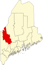 Location within the U.S. state of Maine | |
 Maine's location within the U.S. | |
| Coordinates: 44°52′45″N 70°23′17″W / 44.879196°N 70.387917°W | |
| Country | |
| State | |
| Founded | May 9, 1838 |
| Named for | Benjamin Franklin |
| Seat | Farmington |
| Largest town | Farmington |
| Area | |
| • Total | 1,743 sq mi (4,510 km2) |
| • Land | 1,697 sq mi (4,400 km2) |
| • Water | 47 sq mi (120 km2) 2.7%% |
| Population (2010) | |
| • Total | 30,768 |
| • Estimate (2019) | 30,199 |
| ��� Density | 18/sq mi (7/km2) |
| Time zone | UTC−5 (Eastern) |
| • Summer (DST) | UTC−4 (EDT) |
| Congressional district | 2nd |
| Website | www |

Franklin County is a county located in the state of Maine, in the United States. As of the 2010 census, the population was 30,768,[1] making it the second-least populous county in Maine. Its county seat is Farmington.[2] The county was established on May 9, 1838 and named for Benjamin Franklin.[3]
Geography[]
According to the U.S. Census Bureau, the county has a total area of 1,743 square miles (4,510 km2), of which 1,697 square miles (4,400 km2) is land and 47 square miles (120 km2) (2.7%) is water.[4] The county high point is Sugarloaf Mountain, the ski mountain in Carrabassett Valley whose elevation is 4237 feet.
Adjacent counties and municipalities[]
- Somerset County – northeast
- Kennebec County – southeast
- Androscoggin County – south
- Oxford County – southwest
- Le Granit Regional County Municipality, Quebec – northwest
Demographics[]
| Historical population | |||
|---|---|---|---|
| Census | Pop. | %± | |
| 1840 | 20,801 | — | |
| 1850 | 20,027 | −3.7% | |
| 1860 | 20,403 | 1.9% | |
| 1870 | 18,807 | −7.8% | |
| 1880 | 18,180 | −3.3% | |
| 1890 | 17,053 | −6.2% | |
| 1900 | 18,444 | 8.2% | |
| 1910 | 19,119 | 3.7% | |
| 1920 | 19,825 | 3.7% | |
| 1930 | 19,941 | 0.6% | |
| 1940 | 19,896 | −0.2% | |
| 1950 | 20,682 | 4.0% | |
| 1960 | 20,069 | −3.0% | |
| 1970 | 22,444 | 11.8% | |
| 1980 | 27,098 | 20.7% | |
| 1990 | 29,008 | 7.0% | |
| 2000 | 29,467 | 1.6% | |
| 2010 | 30,768 | 4.4% | |
| 2020 | 29,456 | −4.3% | |
| U.S. Decennial Census[5] 1790–1960[6] 1900–1990[7] 1990–2000[8] 2010–2016[1] | |||
2015[]
As of 2015 the largest self-reported ancestry groups in Franklin County, Maine are:[9]
| hideLargest ancestries (2015) | Percent |
|---|---|
| English |
22.4% |
| French or French Canadian |
19.1% |
| Irish |
14.9% |
| "American" |
8.5% |
| German |
6.1% |
| Scottish |
5.0% |
| Italian |
4.2% |
| Scots-Irish |
1.7% |
2000 census[]
As of the census[10] of 2000, there were 29,467 people, 11,806 households, and 7,744 families living in the county. The population density was 17 people per square mile (7/km2). There were 19,159 housing units at an average density of 11 per square mile (4/km2). The racial makeup of the county was 97.96% White, 0.24% Black or African American, 0.37% Native American, 0.43% Asian, 0.02% Pacific Islander, 0.17% from other races, and 0.81% from two or more races. 0.54% of the population were Hispanic or Latino of any race. 26.3% were of English, 13.8% United States or American, 12.2% French, 9.2% Irish, 7.9% French Canadian, and 5.3% Scottish ancestry according to Census 2000. 95.7% spoke English and 2.9% French as their first language.
There were 11,806 households, out of which 29.50% had children under the age of 18 living with them, 52.40% were married couples living together, 9.20% had a female householder with no husband present, and 34.40% were non-families. 25.80% of all households were made up of individuals, and 10.50% had someone living alone who was 65 years of age or older. The average household size was 2.40 and the average family size was 2.88.
In the county, the population was spread out, with 23.50% under the age of 18, 11.10% from 18 to 24, 26.40% from 25 to 44, 24.80% from 45 to 64, and 14.20% who were 65 years of age or older. The median age was 38 years. For every 100 females there were 93.40 males. For every 100 females age 18 and over, there were 89.20 males.
The median income for a household in the county was $31,459, and the median income for a family was $37,863. Males had a median income of $30,475 versus $20,442 for females. The per capita income for the county was $15,796. About 10.70% of families and 14.60% of the population were below the poverty line, including 17.90% of those under age 18 and 9.50% of those age 65 or over.
2010 census[]
As of the 2010 United States Census, there were 30,768 people, 13,000 households, and 8,129 families living in the county.[11] The population density was 18.1 inhabitants per square mile (7.0/km2). There were 21,709 housing units at an average density of 12.8 per square mile (4.9/km2).[12] The racial makeup of the county was 97.3% white, 0.4% Asian, 0.4% American Indian, 0.2% black or African American, 0.2% from other races, and 1.4% from two or more races. Those of Hispanic or Latino origin made up 1.0% of the population.[11] In terms of ancestry, 23.3% were English, 14.2% were Irish, 7.7% were French Canadian, 7.5% were German, 6.4% were Scottish, and 5.0% were American.[13]
Of the 13,000 households, 26.2% had children under the age of 18 living with them, 48.6% were married couples living together, 9.4% had a female householder with no husband present, 37.5% were non-families, and 28.9% of all households were made up of individuals. The average household size was 2.28 and the average family size was 2.76. The median age was 43.4 years.[11]
The median income for a household in the county was $39,831 and the median income for a family was $48,634. Males had a median income of $38,563 versus $30,024 for females. The per capita income for the county was $20,838. About 10.2% of families and 15.5% of the population were below the poverty line, including 21.2% of those under age 18 and 8.8% of those age 65 or over.[14]
Politics[]
Voter registration[]
| Voter registration and party enrollment as of May 2019 [needs update][15] | |||||
|---|---|---|---|---|---|
| Unenrolled | 8,693 | 35.87% | |||
| Democratic | 6,768 | 27.93% | |||
| Republican | 7,594 | 31.33% | |||
| Green Independent | 1,177 | 4.86% | |||
| Libertarian | 4 | 0.02% | |||
| Total | 24,236 | 100% | |||
Government[]
Franklin County is governed by a three-member county commission. Commissioners meet at 10am on the first and third Monday of each month and are elected in the November general election, serving four year terms. Currently, the three commissioners are:[17]
District One: Gary McGrane (Jay, Wilton, Temple, Carthage)
District Two: Charles Webster (Farmington, Chesterville, New Sharon)
District Three: Clyde Barker (Avon, Carrabassett Valley, Coplin Plantation, Dallas Plantation, Eustis, Industry, Kingfield, New Vineyard, Phillips, Rangeley Plantation, Rangeley, Sandy River Plantation, Strong, Weld, and unorganized territories of East Central Franklin, North Franklin, South Franklin, West Central Franklin and Wyman)
Commissioner Charles Webster was appointed by Governor Paul LePage in 2015 to serve out the rest of Fred Hardy's term, who died on July 4.[18] Webster and Barker are members of the Republican Party, while McGrane belongs to the Democratic Party.
Franklin County belongs to Maine Prosecutorial District Three, which is composed of Franklin, Oxford and Androscoggin Counties. The current district attorney is Andrew S. Robinson, of Farmington who was elected to his first term in 2014. The deputy district attorney is James A. Andrews, who was appointed to that post by Robinson in 2015.[19]
The current county treasurer is Pamela Prodan. She was elected to that position in 2014 and will serve a four term through December 2018. Prodan succeed Mary Frank, who decided to retire instead of run for a second term. The duties of county treasurer include, overseeing fiscal accounting matters, including paying bills, collecting amounts owed the County, reserve/investment accounts, maintaining the County's financial records and other matters related to the County's finances.[20]
Law enforcement[]
Only five municipalities in Franklin County have their own police department (Carrabassett Valley, Farmington, Jay, Rangeley, and Wilton). The Franklin County Sheriff's Department is responsible for patrol and emergency calls in the remaining communities in the county without their own agency. The current sheriff is Scott Nichols, of New Sharon. Nichols was elected to that post in November 2012, defeating incumbent sheriff, Dennis Pike. Pike had spent 46 years in Franklin County law enforcement prior to being defeated by Nichols.[21]
The status of the Franklin County Jail has been contentiously debated issue within the county and state for several years. In 2008, Governor John Baldacci signed into law a bill which consolidated county jails in an effort to reduce costs. As a result, the Franklin County jail was designated a 72-hour holding facility. Any inmates who needed to be held longer than the three-day maximum had to be transported to the Somerset County Jail in East Madison, which county jail officials said was a waste of department time and money. Jail consolidation has also led to jail overcrowding statewide.[22] When the Somerset Jail reached its maximum capacity, inmates were forced to be transported to another jail within the state, sometimes hours away which Franklin County officials again said wasted time and money.
In 2012, the Somerset County Commissioners voted not to accept any more inmates from outside the county as the state Board of Corrections withheld its third quarter payment. While the vote allowed current inmates to stay at the jail, it required all future inmates to be sent to Two Bridges Regional Jail in Wiscasset. In 2013, the Maine Legislature's Public Safety and Criminal Justice Committee voted 11-0 to allow the Franklin County jail to return to full service status.[23]
In 2014, the Franklin County Commissioners voted to withhold all payments to the state for jail inmates. Public outrage over the jail issue also pressured the state to give the county full service rights. In 2014 an 800-member Facebook group was created and several protests were staged in front of the county courthouse. In 2015, the State Board of Corrections voted to grant the county a fully operational jail, officially ending the seven year conflict between the county and the state.[24]
Communities[]
Towns[]
Plantations[]
Census-designated places[]
Unorganized territories[]
Unincorporated communities[]
- Dryden
- East Dixfield
- East Wilton
- Farmington Falls
- Freeman
- Macy
- Madrid
- Mooselookmeguntic
- North Jay
- Oquossoc
See also[]
References[]
- ^ Jump up to: a b "State & County QuickFacts". United States Census Bureau. Archived from the original on June 6, 2011. Retrieved August 19, 2013.
- ^ "Find a County". National Association of Counties. Archived from the original on 2011-05-31. Retrieved 2011-06-07.
- ^ Gannett, Henry (1905). The Origin of Certain Place Names in the United States. Govt. Print. Off. pp. 131.
- ^ "2010 Census Gazetteer Files". United States Census Bureau. August 22, 2012. Archived from the original on September 9, 2014. Retrieved September 7, 2014.
- ^ "U.S. Decennial Census". United States Census Bureau. Retrieved September 7, 2014.
- ^ "Historical Census Browser". University of Virginia Library. Retrieved September 7, 2014.
- ^ "Population of Counties by Decennial Census: 1900 to 1990". United States Census Bureau. Retrieved September 7, 2014.
- ^ "Census 2000 PHC-T-4. Ranking Tables for Counties: 1990 and 2000" (PDF). United States Census Bureau. Retrieved September 7, 2014.
- ^ Bureau, U.S. Census. "American FactFinder - Results". factfinder.census.gov. Archived from the original on 13 February 2020. Retrieved 18 April 2018.
- ^ "U.S. Census website". United States Census Bureau. Retrieved 2008-01-31.
- ^ Jump up to: a b c "DP-1 Profile of General Population and Housing Characteristics: 2010 Demographic Profile Data". United States Census Bureau. Archived from the original on 2020-02-13. Retrieved 2016-01-21.
- ^ "Population, Housing Units, Area, and Density: 2010 - County". United States Census Bureau. Archived from the original on 2020-02-13. Retrieved 2016-01-21.
- ^ "DP02 SELECTED SOCIAL CHARACTERISTICS IN THE UNITED STATES – 2006-2010 American Community Survey 5-Year Estimates". United States Census Bureau. Archived from the original on 2020-02-13. Retrieved 2016-01-21.
- ^ "DP03 SELECTED ECONOMIC CHARACTERISTICS – 2006-2010 American Community Survey 5-Year Estimates". United States Census Bureau. Archived from the original on 2020-02-13. Retrieved 2016-01-21.
- ^ Bureau of Corporations, Elections & Commissions (5 May 2019). "Registered & Enrolled Voters - Statewide" (PDF). Department of the Secretary of State, State of Maine. p. 11. Retrieved 13 November 2019.
- ^ Leip, David. "Dave Leip's Atlas of U.S. Presidential Elections". uselectionatlas.org. Retrieved 18 April 2018.
- ^ "franklincountyme-gov". franklincountyme-gov. Retrieved 2016-05-24.
- ^ Perry, Donna M.; Journal, Sun. "LePage appoints Charlie Webster as Franklin County commissioner". The Bangor Daily News. Retrieved 2016-05-24.
- ^ "franklincountyme-gov". franklincountyme-gov. Retrieved 2016-05-24.
- ^ "franklincountyme-gov". franklincountyme-gov. Retrieved 2016-05-24.
- ^ Schroeder, Karen (2012-12-30). "After 46 years, Franklin County Sheriff Dennis Pike hits the road". Central Maine. Retrieved 2016-05-24.
- ^ "Overcrowding intensifies problems at Maine's county jails - The Portland Press Herald / Maine Sunday Telegram". The Portland Press Herald / Maine Sunday Telegram. 2015-01-19. Retrieved 2016-05-26.
- ^ "Bill to return local jail to full service fails; Somerset County refuses Franklin County's detainees | Daily Bulldog". www.dailybulldog.com. Retrieved 2016-05-26.
- ^ Schroeder, Kaitlin (2015-01-13). "Franklin County jail to return to full-time lockup status". Central Maine. Retrieved 2016-05-26.
External links[]
- http://www.franklincountymaine.org/ Franklin County Chamber of Commerce
- Franklin County on Maine.gov
| show Places adjacent to Franklin County, Maine |
|---|
| show Municipalities and communities of Franklin County, Maine, United States |
|---|


| show Authority control |
|---|
- Maine counties
- Franklin County, Maine
- 1838 establishments in Maine
- Populated places established in 1838