Fressancourt
show This article may be expanded with text translated from the corresponding article in French. (December 2008) Click [show] for important translation instructions. |
Fressancourt | |
|---|---|
Commune | |
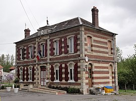 The town hall of Fressancourt | |
show Location of Fressancourt | |
 Fressancourt | |
| Coordinates: 49°38′00″N 3°25′35″E / 49.6333°N 3.4264°ECoordinates: 49°38′00″N 3°25′35″E / 49.6333°N 3.4264°E | |
| Country | France |
| Region | Hauts-de-France |
| Department | Aisne |
| Arrondissement | Laon |
| Canton | Tergnier |
| Government | |
| • Mayor (2020–2026) | Michel Degouy[1] |
| Area 1 | 2.51 km2 (0.97 sq mi) |
| Population (Jan. 2018)[2] | 187 |
| • Density | 75/km2 (190/sq mi) |
| Time zone | UTC+01:00 (CET) |
| • Summer (DST) | UTC+02:00 (CEST) |
| INSEE/Postal code | 02335 /02800 |
| Elevation | 57–113 m (187–371 ft) (avg. 68 m or 223 ft) |
| 1 French Land Register data, which excludes lakes, ponds, glaciers > 1 km2 (0.386 sq mi or 247 acres) and river estuaries. | |


Fressancourt is a commune in the Aisne department in Hauts-de-France in northern France.
Population[]
|
|
See also[]
References[]
- ^ "Répertoire national des élus: les maires". data.gouv.fr, Plateforme ouverte des données publiques françaises (in French). 2 December 2020.
- ^ "Populations légales 2018". INSEE. 28 December 2020.
| Wikimedia Commons has media related to Fressancourt. |
This Laon arrondissement geographical article is a stub. You can help Wikipedia by . |
Categories:
- Communes of Aisne
- Laon arrondissement geography stubs