Guidel
Guidel
Gwidel | |
|---|---|
 The beach at Guidel, and the Laïta | |
 Coat of arms | |
show Location of Guidel | |
 Guidel | |
| Coordinates: 47°47′29″N 3°29′14″W / 47.7914°N 3.4872°WCoordinates: 47°47′29″N 3°29′14″W / 47.7914°N 3.4872°W | |
| Country | France |
| Region | Brittany |
| Department | Morbihan |
| Arrondissement | Lorient |
| Canton | Guidel |
| Intercommunality | Lorient Agglomération |
| Government | |
| • Mayor (2020–2026) | Joël Daniel[1] |
| Area 1 | 52.29 km2 (20.19 sq mi) |
| Population (Jan. 2018)[2] | 11,659 |
| • Density | 220/km2 (580/sq mi) |
| Time zone | UTC+01:00 (CET) |
| • Summer (DST) | UTC+02:00 (CEST) |
| INSEE/Postal code | 56078 /56520 |
| Elevation | 0–70 m (0–230 ft) |
| 1 French Land Register data, which excludes lakes, ponds, glaciers > 1 km2 (0.386 sq mi or 247 acres) and river estuaries. | |


Guidel (French pronunciation: [gidɛl]; Breton: Gwidel) is a commune in the Morbihan department of Brittany in north-western France.
Demographics[]
Inhabitants of Guidel are called in French Guidélois.
Cemetery[]
The communal cemetery, containing 108 tombs from the World War II, has been listed by the Commonwealth War Graves Commission.[3] Most of the casualties were belonging to the Royal Air Force, Royal Canadian Air Force, Royal Australian Air Force and Royal New Zealand Air Force.
Breton language[]
The municipality launched a linguistic plan through Ya d'ar brezhoneg on March the 27th of 2007.
In 2008, there was 6,44% of the children attended the bilingual schools in primary education.[4]
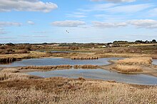
Ponds of Petit and Grand Loc'h
See also[]
- Communes of the Morbihan department
- Hortense Clémentine Tanvet Sculptor of war memorial
References[]
- ^ "Maires du Morbihan" (PDF). Préfecture du Morbihan. 7 July 2020.
- ^ "Populations légales 2018". INSEE. 28 December 2020.
- ^ (in English) CWGG: Guidel communal cemetery
- ^ (in French) Ofis ar Brezhoneg: Enseignement bilingue
External links[]
| Wikimedia Commons has media related to Guidel. |
- Official site (in French)
- Base Mérimée: Search for heritage in the commune, Ministère français de la Culture. (in French)
- Mayors of Morbihan Association (in French)
| show Authority control |
|---|
This Morbihan geographical article is a stub. You can help Wikipedia by . |
Categories:
- Communes of Morbihan
- Morbihan geography stubs