Hariyawan
Hariyawan
Hariāwān | |
|---|---|
Populated place | |
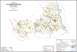 Map showing Hariyawan (#064) in Hariyawan CD block | |
 Hariyawan Location in Uttar Pradesh, India | |
| Coordinates: 27°31′43″N 80°10′26″E / 27.5286°N 80.1739°ECoordinates: 27°31′43″N 80°10′26″E / 27.5286°N 80.1739°E[1] | |
| Country | India |
| State | Uttar Pradesh |
| District | Hardoi |
| Area | |
| • Total | 3.10 km2 (1.20 sq mi) |
| Population (2011)[2] | |
| • Total | 2,997 |
| • Density | 970/km2 (2,500/sq mi) |
| Languages | |
| • Official | Hindi |
| Time zone | UTC+5:30 (IST) |


Hariyawan is a village and corresponding community development block in Hardoi district of Uttar Pradesh, India.[2] It hosts a market on Wednesdays and Sundays.[3][4] The main staple foods here are wheat and rice.[3][4] As of 2011, its population is 2,997, in 508 households.[2]
Demographic history[]
The 1961 census recorded Hariyawan as comprising three hamlets, with a total population of 1,573 (832 male and 746 female), in 247 households and 221 physical houses.[5] The area of the village was given as 766 acres.[5]
The 1981 census recorded Hariyawan as having a population of 2,099, in 384 households, and covering an area of 310.00 hectares.[4]
Villages[]
Hariyawan CD block has the following 92 villages:[2]
| Village name | Total land area (hectares) | Population (in 2011) |
|---|---|---|
| 164.1 | 1,487 | |
| 242.6 | 1,228 | |
| 90.8 | 241 | |
| 52.9 | 1,072 | |
| 889.8 | 4,623 | |
| 119.8 | 8,041 | |
| 48 | 278 | |
| 784.9 | 4,446 | |
| 94.7 | 574 | |
| 536.3 | 3,340 | |
| 70.2 | 273 | |
| 628.5 | 3,327 | |
| Khajuha | 44.2 | 120 |
| 41.9 | 123 | |
| 957.2 | 4,985 | |
| 260.2 | 1,374 | |
| Kurseli | 1,869.3 | 10,404 |
| 727.7 | 3,010 | |
| 64 | 726 | |
| 181 | 888 | |
| 71.1 | 643 | |
| 216 | 559 | |
| Hariyawan (block headquarters) | 310 | 2,997 |
| 130 | 954 | |
| 425.7 | 2,526 | |
| 44.7 | 398 | |
| 143.1 | 817 | |
| 800.1 | 3,219 | |
| 153 | 1,415 | |
| 282 | 1,166 | |
| 638.5 | 3,572 | |
| 195.6 | 1,258 | |
| 132.8 | 1,203 | |
| 306.5 | 1,734 | |
| 109.7 | 637 | |
| 126.1 | 662 | |
| 118.6 | 1,111 | |
| 95.4 | 564 | |
| 566 | 4,297 | |
| 208 | 1,186 | |
| 632.3 | 3,996 | |
| 198.7 | 1,388 | |
| 48.9 | 467 | |
| 364.5 | 2,510 | |
| 149.1 | 926 | |
| 165.3 | 330 | |
| 87.1 | 997 | |
| 253.4 | 1,995 | |
| 83.9 | 518 | |
| 423.6 | 3,929 | |
| 198.8 | 1,755 | |
| 977.6 | 7,060 | |
| 359.6 | 2,759 | |
| 190.8 | 2,843 | |
| 190.8 | 2,843 | |
| 337.6 | 2,924 | |
| 119.5 | 1,111 | |
| 202.5 | 1,879 | |
| 153.5 | 489 | |
| 496.5 | 2,384 | |
| 287.1 | 1,247 | |
| 91.3 | 1,024 | |
| 599.4 | 4,368 | |
| 509.1 | 2,365 | |
| 163.8 | 1,533 | |
| 248.7 | 2,183 | |
| 293.4 | 3,042 | |
| 183.9 | 867 | |
| 208.4 | 1,583 | |
| 672.2 | 4,931 | |
| 338.2 | 2,291 | |
| 253.2 | 1,791 | |
| 288.4 | 2,316 | |
| 611 | 2,696 | |
| 290.4 | 2,962 | |
| 69.6 | 317 | |
| 300.5 | 814 | |
| 226.5 | 363 | |
| 864.9 | 0 | |
| 238 | 0 | |
| 400.9 | 1,948 | |
| 413.1 | 722 | |
| 74.8 | 0 | |
| 72.7 | 523 | |
| 58.5 | 179 | |
| 185 | 819 | |
| 541 | 3,835 | |
| 329 | 1,513 | |
| 134.8 | 0 | |
| 330.9 | 1,117 | |
| 220.2 | 502 | |
| 301.2 | 1,969 |
References[]
- ^ Search for "Hariawan" here https://geonames.nga.mil/namesgaz/. Missing or empty
|title=(help) - ^ a b c d e "Census of India 2011: Uttar Pradesh District Census Handbook - Hardoi, Part A (Village and Town Directory)" (PDF). Census 2011 India. pp. 317–34. Retrieved 8 June 2021.
- ^ a b Census 1971 Uttar Pradesh: District Census Handbook Part X-A: Village & Town Directory, District Hardoi (PDF). 1972. pp. 86–7. Retrieved 8 June 2021.
- ^ a b c Census 1981 Uttar Pradesh: District Census Handbook Part XIII-A: Village & Town Directory, District Hardoi (PDF). 1982. pp. 120–1. Retrieved 8 June 2021.
- ^ a b Census 1961: District Census Handbook, Uttar Pradesh (36 - Hardoi District) (PDF). Lucknow. 1965. pp. lviii-lix of section "Hardoi Tahsil". Retrieved 8 June 2021.
Categories:
- Villages in Hardoi district