Jackson County, Mississippi
Jackson County | |
|---|---|
U.S. county | |
 The Jackson County Courthouse in Pascagoula | |
 Seal | |
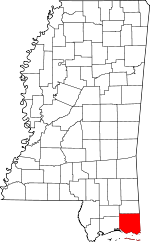 Location within the U.S. state of Mississippi | |
 Mississippi's location within the U.S. | |
| Coordinates: 30°28′N 88°37′W / 30.46°N 88.62°W | |
| Country | |
| State | |
| Founded | 1812 |
| Named for | Andrew Jackson |
| Seat | Pascagoula |
| Largest city | Pascagoula |
| Area | |
| • Total | 1,043 sq mi (2,700 km2) |
| • Land | 723 sq mi (1,870 km2) |
| • Water | 321 sq mi (830 km2) 31% |
| Population (2010) | |
| • Total | 139,668 |
| • Estimate (2019) | 143,617 |
| • Density | 199/sq mi (77/km2) |
| Time zone | UTC−6 (Central) |
| • Summer (DST) | UTC−5 (CDT) |
| Congressional district | 4th |
| Website | www |

Jackson County is a county located in the U.S. state of Mississippi. As of the 2010 census, the population was 139,668,[1] making it the fifth-most populous county in Mississippi. Its county seat is Pascagoula.[2] The county was named for Andrew Jackson, general in the United States Army and afterward President of the United States.[3]
Jackson County is included in the Pascagoula, MS Metropolitan Statistical Area. It is located at the southeastern tip of the state. The county has sandy soil and is in the Piney Woods area. It borders the state of Alabama on its east side.
The county was severely damaged by both Hurricane Camille in August 1969 and Hurricane Katrina on August 29, 2005, which caused catastrophic effects.
Geography[]
According to the U.S. Census Bureau, the county has a total area of 1,043 square miles (2,700 km2), of which 723 square miles (1,870 km2) is land and 321 square miles (830 km2) (31%) is water.[4] It is the largest county in Mississippi by total area.
Major highways[]
Adjacent counties[]
- George County - north
- Mobile County, Alabama - east
- Harrison County - west
- Stone County - northwest
National protected areas[]
- De Soto National Forest (part)
- Grand Bay National Wildlife Refuge (part)
- Gulf Islands National Seashore (part)
- Mississippi Sandhill Crane National Wildlife Refuge
Demographics[]
| Historical population | |||
|---|---|---|---|
| Census | Pop. | %± | |
| 1820 | 1,682 | — | |
| 1830 | 1,792 | 6.5% | |
| 1840 | 1,965 | 9.7% | |
| 1850 | 3,196 | 62.6% | |
| 1860 | 4,122 | 29.0% | |
| 1870 | 4,362 | 5.8% | |
| 1880 | 7,607 | 74.4% | |
| 1890 | 11,251 | 47.9% | |
| 1900 | 16,513 | 46.8% | |
| 1910 | 15,451 | −6.4% | |
| 1920 | 19,208 | 24.3% | |
| 1930 | 15,973 | −16.8% | |
| 1940 | 20,601 | 29.0% | |
| 1950 | 31,401 | 52.4% | |
| 1960 | 55,522 | 76.8% | |
| 1970 | 87,975 | 58.5% | |
| 1980 | 118,015 | 34.1% | |
| 1990 | 115,243 | −2.3% | |
| 2000 | 131,420 | 14.0% | |
| 2010 | 139,668 | 6.3% | |
| 2019 (est.) | 143,617 | 2.8% | |
| U.S. Decennial Census[5] 1790-1960[6] 1900-1990[7] 1990-2000[8] 2010-2013[1] 2019[9] | |||
As of the census[10] of 2000, there were 131,420 people, 47,676 households, and 35,709 families residing in the county. The population density was 181 people per square mile (70/km2). There were 51,678 housing units at an average density of 71 per square mile (27/km2). The racial makeup of the county was 75.35% White, 20.87% Black or African American, 0.33% Native American, 1.57% Asian, 0.04% Pacific Islander, 0.72% from other races, and 1.12% from two or more races. 2.14% of the population were Hispanic or Latino of any race.
There were 47,676 households, out of which 37.00% had children under the age of 18 living with them, 55.70% were married couples living together, 14.50% had a female householder with no husband present, and 25.10% were non-families. 20.80% of all households were made up of individuals, and 7.10% had someone living alone who was 65 years of age or older. The average household size was 2.72 and the average family size was 3.14.
In the county, the population was spread out, with 27.70% under the age of 18, 9.30% from 18 to 24, 29.80% from 25 to 44, 22.90% from 45 to 64, and 10.30% who were 65 years of age or older. The median age was 35 years. For every 100 females, there were 98.20 males. For every 100 females age 18 and over, there were 95.90 males.
The median income for a household in the county was $39,118, and the median income for a family was $45,091. Males had a median income of $32,996 versus $22,770 for females. The per capita income for the county was $17,768. About 10.50% of families and 12.70% of the population were below the poverty line, including 17.80% of those under age 18 and 12.10% of those age 65 or over.
Jackson County has the fifth highest per capita income in the State of Mississippi.
Public Safety[]
The Jackson County Sheriff's Office provides law enforcement services for communities in the county that do not have their own local law enforcement. These communities are known as Census-Designated Places, or CDPs.
Education[]
The Jackson County School District serves the Hurley, Wade, Big Point, Three Rivers, Harleston, Vestry, Latimer, and Vancleave communities, along with St. Martin and Escatawpa. The Pascagoula-Gautier School District serves Pascagoula and the City of Gautier. The Moss Point School District serves Moss Point, Mississippi, and part of Escatawpa, Mississippi. The Ocean Springs School District serves most of Ocean Springs.
Communities[]
Cities[]
- Gautier
- Moss Point
- Ocean Springs
- Pascagoula (county seat)
Census-designated places[]
Unincorporated places[]
- East Moss Point
- Gulf Islands National Seashore
Ghost towns[]
Politics[]
See also[]
- National Register of Historic Places listings in Jackson County, Mississippi
- L.N. Dantzler Lumber Company
References[]
- ^ Jump up to: a b "State & County QuickFacts". United States Census Bureau. Archived from the original on June 7, 2011. Retrieved September 3, 2013.
- ^ "Find a County". National Association of Counties. Archived from the original on May 31, 2011. Retrieved 2011-06-07.
- ^ Gannett, Henry (1905). The Origin of Certain Place Names in the United States. Govt. Print. Off. p. 167.
- ^ "2010 Census Gazetteer Files". United States Census Bureau. August 22, 2012. Archived from the original on September 28, 2013. Retrieved November 4, 2014.
- ^ "U.S. Decennial Census". United States Census Bureau. Retrieved November 4, 2014.
- ^ "Historical Census Browser". University of Virginia Library. Retrieved November 4, 2014.
- ^ "Population of Counties by Decennial Census: 1900 to 1990". United States Census Bureau. Retrieved November 4, 2014.
- ^ "Census 2000 PHC-T-4. Ranking Tables for Counties: 1990 and 2000" (PDF). United States Census Bureau. Retrieved November 4, 2014.
- ^ "QuickFacts. Mississippi counties". Retrieved May 20, 2020.
- ^ "U.S. Census website". United States Census Bureau. Retrieved 2008-01-31.
- ^ Leip, David. "Dave Leip's Atlas of U.S. Presidential Elections". uselectionatlas.org. Retrieved 2018-03-02.
- ^ http://geoelections.free.fr/. Retrieved January 13, 2021. Missing or empty
|title=(help)
External links[]
| show Places adjacent to Jackson County, Mississippi |
|---|
| show Municipalities and communities of Jackson County, Mississippi, United States |
|---|


| show Authority control |
|---|
- Mississippi counties
- Jackson County, Mississippi
- Pascagoula metropolitan area
- 1812 establishments in Mississippi Territory
- Populated places established in 1812