Warren County, Mississippi
Warren County | |
|---|---|
U.S. county | |
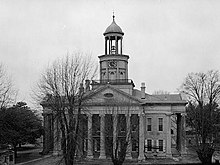
 The Warren County Courthouse in Vicksburg was built c. 1940. It is located across from the Old Courthouse Museum. | |
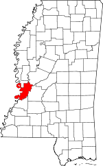 Location within the U.S. state of Mississippi | |
 Mississippi's location within the U.S. | |
| Coordinates: 32°22′N 90°51′W / 32.36°N 90.85°W | |
| Country | |
| State | |
| Founded | 1809 |
| Named for | Joseph Warren |
| Seat | Vicksburg |
| Largest city | Vicksburg |
| Area | |
| • Total | 619 sq mi (1,600 km2) |
| • Land | 589 sq mi (1,530 km2) |
| • Water | 30 sq mi (80 km2) 4.9% |
| Population (2010) | |
| • Total | 48,773 |
| • Estimate (2018) | 46,176 |
| • Density | 79/sq mi (30/km2) |
| Time zone | UTC−6 (Central) |
| • Summer (DST) | UTC−5 (CDT) |
| Congressional district | 2nd |
| Website | www |

Warren County is a county located in the U.S. state of Mississippi. As of the 2010 census, the population was 48,773.[1] Its county seat is Vicksburg.[2] Created by legislative act of 22 December 1809, Warren County is named for American Revolutionary War officer Joseph Warren.
Part of the Mississippi Delta and the historic cotton culture, Warren County is included in the Vicksburg, MS Micropolitan Statistical Area, which is also included in the Jackson-Vicksburg-Brookhaven, MS Combined Statistical Area.
Geography[]
According to the U.S. Census Bureau, the county has a total area of 619 square miles (1,600 km2), of which 589 square miles (1,530 km2) is land and 30 square miles (78 km2) (4.9%) is water.[3]
The county exists in two sections, connected only by a narrow 500ft wide section between Madison Parish, Louisiana and Issaquena County, Mississippi along the delta of the Yazoo River. This area was once along the Mississippi River, but has since become an oxbow lake and marsh and no roads traverse this strip of land.
Major highways[]
Adjacent counties[]
- Issaquena County (north)
- Yazoo County (northeast)
- Hinds County (east)
- Claiborne County (south)
- Tensas Parish, Louisiana (southwest)
- Madison Parish, Louisiana (west)
National protected areas[]
Demographics[]
| Historical population | |||
|---|---|---|---|
| Census | Pop. | %± | |
| 1810 | 1,114 | — | |
| 1820 | 2,693 | 141.7% | |
| 1830 | 7,861 | 191.9% | |
| 1840 | 15,820 | 101.2% | |
| 1850 | 18,120 | 14.5% | |
| 1860 | 20,696 | 14.2% | |
| 1870 | 26,769 | 29.3% | |
| 1880 | 31,238 | 16.7% | |
| 1890 | 33,164 | 6.2% | |
| 1900 | 40,912 | 23.4% | |
| 1910 | 37,488 | −8.4% | |
| 1920 | 33,362 | −11.0% | |
| 1930 | 35,785 | 7.3% | |
| 1940 | 39,595 | 10.6% | |
| 1950 | 39,616 | 0.1% | |
| 1960 | 42,206 | 6.5% | |
| 1970 | 44,981 | 6.6% | |
| 1980 | 51,627 | 14.8% | |
| 1990 | 47,880 | −7.3% | |
| 2000 | 49,644 | 3.7% | |
| 2010 | 48,773 | −1.8% | |
| 2018 (est.) | 46,176 | [4] | −5.3% |
| U.S. Decennial Census[5] 1790-1960[6] 1900-1990[7] 1990-2000[8] 2010-2013[1] | |||

As of the 2010 United States Census, there were 48,773 people living in the county. 50.3% were White, 47.0% Black or African American, 0.8% Asian, 0.3% Native American, 0.7% of some other race and 0.9% of two or more races. 1.8% were Hispanic or Latino (of any race).
As of the census[10] of 2000, there were 49,644 people, 18,756 households, and 13,222 families living in the county. The population density was 85 people per square mile (33/km2). There were 20,789 housing units at an average density of 35 per square mile (14/km2). The racial makeup of the county was 54.97% White, 43.19% Black or African American, 0.23% Native American, 0.62% Asian, 0.02% Pacific Islander, 0.33% from other races, and 0.66% from two or more races. 1.04% of the population were Hispanic or Latino of any race.
2005 census estimates based on the American Community Survey suggested that non-Hispanic whites were 51.5% of Warren County's population. Warren County was the only county in Mississippi along the Mississippi River, in addition to Desoto, where whites made up a majority of the population. African Americans were 46.0% of the county's population. People identifying as of two or more races were 0.6%, less than in the previous ACS. The Latino population was 1.2% of the total for the county.[11]
In 2000 there were 18,756 households, out of which 35.60% had children under the age of 18 living with them, 46.80% were married couples living together, 19.10% had a female householder with no husband present, and 29.50% were non-families. 25.80% of all households were made up of individuals, and 9.70% had someone living alone who was 65 years of age or older. The average household size was 2.61 and the average family size was 3.14.
In the county, the population was spread out, with 28.50% under the age of 18, 9.10% from 18 to 24, 28.40% from 25 to 44, 22.40% from 45 to 64, and 11.70% who were 65 years of age or older. The median age was 35 years. For every 100 females there were 88.30 males. For every 100 females age 18 and over, there were 84.40 males.
The median income for a household in the county was $35,056, and the median income for a family was $41,706. Males had a median income of $33,566 versus $21,975 for females. The per capita income for the county was $17,527. About 15.00% of families and 18.70% of the population were below the poverty line, including 27.80% of those under age 18 and 16.20% of those age 65 or over.
Warren County has the seventh highest per capita income in the State of Mississippi.
Government and politics[]
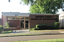
Board of Supervisors[]
Members are elected from each of the five supervisory districts. The Board of Supervisors guides and establishes policies for the county government. Members of the board of make decisions regarding economic development, public health and welfare and county roads.
National politics[]
Communities[]

City[]
- Vicksburg (county seat and only municipality)
Census-designated places[]
Unincorporated communities[]
Ghost town[]
Notable people[]
- Sarah Gibson Humphreys (1830–1907), author and woman suffragist
See also[]
- National Register of Historic Places listings in Warren County, Mississippi
- Joseph A. Biedenharn, first bottler of Coca-Cola
References[]
- ^ Jump up to: a b "State & County QuickFacts". United States Census Bureau. Retrieved September 7, 2013.
- ^ "Find a County". National Association of Counties. Retrieved 2011-06-07.
- ^ "2010 Census Gazetteer Files". United States Census Bureau. August 22, 2012. Archived from the original on September 28, 2013. Retrieved November 8, 2014.
- ^ "Population and Housing Unit Estimates". Retrieved November 8, 2019.
- ^ "U.S. Decennial Census". United States Census Bureau. Retrieved November 8, 2014.
- ^ "Historical Census Browser". University of Virginia Library. Retrieved November 8, 2014.
- ^ "Population of Counties by Decennial Census: 1900 to 1990". United States Census Bureau. Retrieved November 8, 2014.
- ^ "Census 2000 PHC-T-4. Ranking Tables for Counties: 1990 and 2000" (PDF). United States Census Bureau. Retrieved November 8, 2014.
- ^ Based on 2000 census data
- ^ "U.S. Census website". United States Census Bureau. Retrieved 2008-01-31.
- ^ Warren County QuickFacts from the US Census Bureau
- ^ Leip, David. "Dave Leip's Atlas of U.S. Presidential Elections". uselectionatlas.org. Retrieved 2018-05-10.
External links[]
| show Places adjacent to Warren County, Mississippi |
|---|
| show Municipalities and communities of Warren County, Mississippi, United States |
|---|


Coordinates: 32°22′N 90°51′W / 32.36°N 90.85°W
| show Authority control |
|---|
- Mississippi counties
- Warren County, Mississippi
- Mississippi counties on the Mississippi River
- 1809 establishments in Mississippi Territory
- Populated places established in 1809