Jose W. Diokno Boulevard
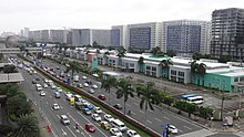 SM Corporate Offices on Jose W. Diokno Boulevard at the Mall of Asia Complex | |||
| Former name(s) | Bay Boulevard | ||
|---|---|---|---|
| Namesake | Jose W. Diokno | ||
| Maintained by | Philippine Reclamation Authority[a] | ||
| Length | 4.38 km (2.72 mi) | ||
| North end |
| ||
| Major junctions |
Macapagal Boulevard / Magdalena Jalandoni Street Seaside Boulevard Epifanio de los Santos Avenue Coral Way Bradco Avenue Asean Avenue New Seaside Avenue | ||
| South end | Pacific Avenue in Parañaque | ||
J.W. Diokno Boulevard, which is the actual and official street name that stands for Jose W. Diokno Boulevard, is a 4.38-kilometer (2.72 mi) long major collector road that runs north–south along the eastern perimeter of the SM Mall of Asia complex and parallel to Macapagal Boulevard in Bay City, Metro Manila, Philippines. It provides access from the Cultural Center of the Philippines Complex (CCP Complex) and Roxas Boulevard north to the shopping and lifestyle hub by the Manila Bay in Pasay. Motorists tend to use the highway as the less congested alternative route from Manila to the Bay City vis-à-vis its parallel partner road in Macapagal Boulevard. It also connects to Entertainment City further south in Parañaque, and unlike Macapagal Boulevard is situated along the coastline overlooking the Manila Bay.
The 8-lane median-divided boulevard was formerly known as Bay Boulevard. It was renamed in 2007, including the short extension of Gil Puyat Avenue in CCP Complex which connects it to Roxas Boulevard, after Jose Wright Diokno, the founding chair of the Commission on Human Rights, Free Legal Assistance Group (FLAG) founder, and former Filipino senator.[2] The road was constructed by the Philippine Reclamation Authority and was completed in 2011.[3]
Route description[]


Jose W. Diokno Boulevard commences at the intersection with Roxas Boulevard by the World Trade Center Metro Manila as a direct continuation of Gil Puyat Avenue. It travels westward for 1.45 kilometers (0.90 mi) between the CCP Complex to the north and World Trade Center Manila to the south, crossing the northern end of Macapagal Boulevard before curving south past the Government Service Insurance System (GSIS) Complex.
The 100-meter (330 ft) Libertad Bridge carries the boulevard across the Libertad Channel, connecting the CCP and GSIS complexes with the SM Central Business Park where it becomes a north–south road running for 1.28 kilometers (0.80 mi) across the SM Mall of Asia complex. This section of the boulevard is dominated by a roundabout with a large globe in the middle, serving as the terminus to Epifanio de los Santos Avenue.
After crossing the Redemptorist Channel, the boulevard enters Parañaque and the Aseana City and Entertainment City, both mixed-use developments. It runs for 1.65 kilometers (1.03 mi) from Redemptorist to Asia World City, intersecting with Asean Avenue, where the boulevard then becomes part of the NAIA Expressway (NAIAX) At-Grade section. It then comes to a roundabout fronting Westside City Resorts World, where it continues to the southwest. It then intersects New Seaside Road, where NAIAX At-Grade continues and leaves the boulevard.[4] It passes through the Okada Manila development before coming at its southern terminus at or near Pacific Avenue.
Landmarks[]
- Ayala Malls Manila Bay
- Boomland (defunct amusement park)
- CCP Open Field
- CITEM (Center for International Trade Expositions and Missions)
- Government Service Insurance System Center
- Manila Bay Home Depot
- Manila Film Center
- Monarch Parksuites
- Okada Manila
- Philippine Trade Training Center
- Resorts World Bayshore Residential
- SM Mall of Asia
- Four E-Com Center
- Globe Rotunda
- LUXE Duty Free
- Mall of Asia Arena
- Mall of Asia Arena Annex (MAAX) Building
- Mall of Asia Ferry Terminal
- One Esplanade Events Venue
- SM by the Bay Amusement Park
- SM Corporate Office
- SMX Convention Center
- Solaire Resort & Casino
- World Trade Center Manila
Notes[]
References[]
- ^ "PRA, DPWH COMPLETE ROAD REPAIR WORKS IN PARAÑAQUE CITY" (PDF). Philippine Reclamation Authority. January 29, 2021. Retrieved May 14, 2021.
- ^ Republic Act No. 9468 (2007), An Act naming Bay Boulevard located in Pasay City, extending up to Parañaque City, as Jose W. Diokno Boulevard (PDF), retrieved August 14, 2015
- ^ "Land Development". Philippine Reclamation Authority. August 14, 2015.
- ^ "NAIAX". San Miguel Corporation. Retrieved March 24, 2021.
Manila Bay Freeport Zone Manila Bay Area | ||||||||||
| Central Business Park |
|  | ||||||||
| CCP Complex |
| |||||||||
| Financial Center Area |
| |||||||||
| Education |
| |||||||||
| Events |
| |||||||||
| Transportation |
| |||||||||
| Related articles |
| |||||||||
Italics denote buildings under construction or planned. | ||||||||||
Coordinates: 14°32′30″N 120°58′59″E / 14.54167°N 120.98306°E
- Streets in Metro Manila
- Jose W. Diokno