Kamenice (Jihlava District)
Kamenice | |
|---|---|
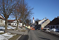 Centre of Kamenice | |
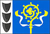 Flag  Coat of arms | |
 Kamenice Location in the Czech Republic | |
| Coordinates: 49°22′0″N 15°46′49″E / 49.36667°N 15.78028°ECoordinates: 49°22′0″N 15°46′49″E / 49.36667°N 15.78028°E | |
| Country | |
| Region | Vysočina |
| District | Jihlava |
| First mentioned | 1358 |
| Area | |
| • Total | 34.03 km2 (13.14 sq mi) |
| Elevation | 510 m (1,670 ft) |
| Population (2020-01-01[1]) | |
| • Total | 1,950 |
| • Density | 57/km2 (150/sq mi) |
| Time zone | UTC+1 (CET) |
| • Summer (DST) | UTC+2 (CEST) |
| Postal code | 588 22 – 588 24, 675 03 |
| Website | www |

Kamenice (Czech pronunciation: [ˈkamɛɲɪtsɛ]) (German: Kamenitz) is a market town in Jihlava District in the Vysočina Region of the Czech Republic. It has about 2,000 inhabitants.
Kamenice lies approximately 15 kilometres (9 mi) east of Jihlava and 127 km (79 mi) south-east of Prague.
Administrative parts[]
Villages of Kamenička, Řehořov and Vržanov are administrative parts of Kamenice.
Notable people[]
- Franz Krommer (1759–1831), composer
References[]
- ^ "Population of Municipalities – 1 January 2020". Czech Statistical Office. 2020-04-30.
| Wikimedia Commons has media related to Kamenice (Jihlava District). |
| show Authority control |
|---|
This Vysočina Region location article is a stub. You can help Wikipedia by . |
Categories:
- Populated places in Jihlava District
- Market towns in the Czech Republic
- Vysočina Region geography stubs