Kankakee, Illinois
Kankakee, Illinois
Theakake | |
|---|---|
City | |
| City of Kankakee | |
 | |
| Nickname(s): City of Restaurants | |
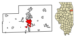 Location of Kankakee in Illinois | |
| Coordinates: 41°7′12″N 87°51′40″W / 41.12000°N 87.86111°WCoordinates: 41°7′12″N 87°51′40″W / 41.12000°N 87.86111°W | |
| Country | United States |
| State | |
| County | Kankakee |
| Established | 1853 |
| Incorporated (city) | 1865 |
| Government | |
| • Type | Mayor-Council |
| • Mayor | Chris Curtis (R) |
| • City Council | 14 aldermen |
| Area | |
| • Total | 15.51 sq mi (40.16 km2) |
| • Land | 15.03 sq mi (38.93 km2) |
| • Water | 0.48 sq mi (1.24 km2) |
| Elevation | 656 ft (200 m) |
| Population | |
| • Total | 27,537 |
| • Estimate (2019)[4] | 26,024 |
| • Density | 1,731.47/sq mi (668.52/km2) |
| Demonym(s) | Kankakeean |
| Time zone | UTC−6 (CST) |
| • Summer (DST) | UTC−5 (CDT) |
| ZIP Code | 60901 |
| Area codes | 815, 779 |
| FIPS code | 17-38934[2] |
| GNIS feature ID | 411300[2] |
| Website | www |

Kankakee /ˌkæŋkəˈkiː/ is a city in and the county seat of Kankakee County, Illinois, United States.[5] The city's name is probably derived from the Miami-Illinois word teeyaahkiki, meaning: "Open country/exposed land/land in open/land exposed to view",[6][7][8][9][10][11][12] in reference to the area's prior status as a marsh. As of 2019, the city's population was 26,024. Kankakee is a principal city of the Kankakee-Bourbonnais-Bradley Metropolitan Statistical Area. It serves as an anchor city in the rural plains outside Chicago, similar to Aurora and Joliet.
History[]
The area of Kankakee was inhabited by the Potawatami beginning sometime in the 18th century. Kankakee was founded in 1854.[13]
Geography[]
Kankakee is located at 41°7′12″N 87°51′36″W / 41.12000°N 87.86000°W (41.12, −87.86).[14]
According to the 2010 census, Kankakee has a total area of 14.62 square miles (37.87 km2), of which 14.14 square miles (36.62 km2) (or 96.72%) is land and 0.48 square miles (1.24 km2) (or 3.28%) is water.[15]
Climate[]
| hideClimate data for Kankakee, Illinois (1991–2020 normals, extremes 1887–present) | |||||||||||||
|---|---|---|---|---|---|---|---|---|---|---|---|---|---|
| Month | Jan | Feb | Mar | Apr | May | Jun | Jul | Aug | Sep | Oct | Nov | Dec | Year |
| Record high °F (°C) | 66 (19) |
74 (23) |
85 (29) |
91 (33) |
99 (37) |
103 (39) |
103 (39) |
107 (42) |
99 (37) |
90 (32) |
79 (26) |
71 (22) |
107 (42) |
| Average high °F (°C) | 32.5 (0.3) |
36.8 (2.7) |
48.6 (9.2) |
61.2 (16.2) |
72.5 (22.5) |
81.9 (27.7) |
84.8 (29.3) |
83.2 (28.4) |
77.9 (25.5) |
65.1 (18.4) |
49.9 (9.9) |
37.8 (3.2) |
61.0 (16.1) |
| Daily mean °F (°C) | 24.4 (−4.2) |
28.2 (−2.1) |
39.0 (3.9) |
50.3 (10.2) |
61.8 (16.6) |
71.5 (21.9) |
74.8 (23.8) |
73.1 (22.8) |
66.5 (19.2) |
54.1 (12.3) |
41.0 (5.0) |
30.0 (−1.1) |
51.2 (10.7) |
| Average low °F (°C) | 16.3 (−8.7) |
19.7 (−6.8) |
29.4 (−1.4) |
39.4 (4.1) |
51.0 (10.6) |
61.0 (16.1) |
64.8 (18.2) |
63.0 (17.2) |
55.1 (12.8) |
43.1 (6.2) |
32.1 (0.1) |
22.1 (−5.5) |
41.4 (5.2) |
| Record low °F (°C) | −29 (−34) |
−21 (−29) |
−7 (−22) |
8 (−13) |
27 (−3) |
38 (3) |
46 (8) |
39 (4) |
30 (−1) |
18 (−8) |
1 (−17) |
−26 (−32) |
−29 (−34) |
| Average precipitation inches (mm) | 2.37 (60) |
1.94 (49) |
2.49 (63) |
3.87 (98) |
5.15 (131) |
5.21 (132) |
4.65 (118) |
3.85 (98) |
3.56 (90) |
3.40 (86) |
2.82 (72) |
2.35 (60) |
41.66 (1,058) |
| Average snowfall inches (cm) | 8.1 (21) |
3.4 (8.6) |
3.0 (7.6) |
0.3 (0.76) |
0.0 (0.0) |
0.0 (0.0) |
0.0 (0.0) |
0.0 (0.0) |
0.0 (0.0) |
0.0 (0.0) |
0.6 (1.5) |
5.3 (13) |
20.7 (53) |
| Average precipitation days (≥ 0.01 in) | 10.7 | 8.6 | 9.1 | 10.9 | 11.7 | 10.1 | 8.6 | 8.6 | 7.6 | 9.2 | 9.0 | 9.0 | 113.1 |
| Average snowy days (≥ 0.1 in) | 5.6 | 4.2 | 1.9 | 0.4 | 0.0 | 0.0 | 0.0 | 0.0 | 0.0 | 0.0 | 0.7 | 3.5 | 16.3 |
| Source: NOAA[16][17] | |||||||||||||
Demographics[]
| Historical population | |||
|---|---|---|---|
| Census | Pop. | %± | |
| 1880 | 5,651 | — | |
| 1890 | 9,025 | 59.7% | |
| 1900 | 13,595 | 50.6% | |
| 1910 | 13,986 | 2.9% | |
| 1920 | 16,753 | 19.8% | |
| 1930 | 20,620 | 23.1% | |
| 1940 | 22,241 | 7.9% | |
| 1950 | 25,856 | 16.3% | |
| 1960 | 27,666 | 7.0% | |
| 1970 | 27,575 | −0.3% | |
| 1980 | 29,633 | 7.5% | |
| 1990 | 30,944 | 4.4% | |
| 2000 | 27,491 | −11.2% | |
| 2010 | 27,537 | 0.2% | |
| 2019 (est.) | 26,024 | [4] | −5.5% |
| U.S. Decennial Census[18] | |||
As of the census[19] of 2000, there were 27,561 people, 10,020 households and 6,272 families residing within the city. The population density was 2,239.8 people per square mile (865.1/km2). There were 10,965 housing units at an average density of 893.4 per square mile (345.0/km2). The racial makeup of the city was 50.92% White, 41.07% African American, 0.27% Native American, 0.32% Asian, 0.03% Pacific Islander, 5.50% from other races, and 1.90% from two or more races. Hispanic or Latino of any race were 9.25% of the population.
There were 10,020 households, out of which 34.4% had children under the age of 18 living with them, 36.4% were married couples living together, 21.2% had a female householder with no husband present, and 37.4% were non-families. 31.5% of all households were made up of individuals, and 13.9% had someone living alone who was 65 years of age or older. The average household size was 2.60, and the average family size was 3.28.
In the city, the population was spread out, with 29.5% under the age of 18, 9.7% from 18 to 24, 28.7% from 25 to 44, 18.7% from 45 to 64, and 13.4% who were 65 years of age or older. The median age was 32 years. For every 100 females, there were 91.8 males. For every 100 females age 18 and over, there were 86.2 males.
The median income for a household in the city was $30,469, and the median income for a family was $36,428. Males had a median income of $30,894 versus $22,928 for females. The per capita income for the city was $15,479. About 18.1% of families and 21.4% of the population were below the poverty line, including 29.3% of those under age 18 and 11.7% of those age 65 or over.
Government[]

Kankakee is governed by the mayor council system. The city council consists of fourteen members who are elected from seven wards (two per ward). The mayor and city clerk are elected in a citywide vote.[citation needed] Library service is provided by the Kankakee Public Library.
Transportation[]

Airport[]
This section needs additional citations for verification. (May 2020) |
Kankakee is served by the Greater Kankakee Airport, a general aviation facility located in the southern portion of Kankakee.[20]
The Kankakee Valley Airport Authority was formed in 1957. The location of the airport was chosen South of Kankakee in 1959. The Greater Kankakee Airport has been officially serving the Kankakee community since 1962. It is located 50 miles south of downtown Chicago and 70 miles north of Champaign, directly along Interstate 57 at the 308 exit. In 1966 the main runway was expanded, successfully attracting a commercial carrier. Air Wisconsin, Inc. began operating in 1967. Due to the commercial operations the Airport was able to build the terminal building in 1968, which is still standing today. The airport continues to serve the community though general aviation and is home to over 100 private hangars housing helicopter, singe engine aircraft, ultralights, and turbine powered aircraft.
The Greater Kankakee Airport was featured in The Hunter.
The Greater Kankakee Airport has received recognition over the years for its outstanding service to Kankakee County. The airport has been awarded the General Aviation – Publicly Owned Airport of the year award by the Illinois Division of Aeronautics in 2001 and 2012.
In September 2013 the Army National Guard broke ground on the Army Aviation Support Facility, which was completed in 2017. The facility houses 13 UH-60 Blackhawk helicopters.
Greater Kankakee Airport covers an area of 950 acres (380 ha) (384 ha) at an elevation of 629 feet (192 m) above mean sea level. It has two runways with asphalt surfaces: 4/22 is 5,981 by 100 feet (1,823 x 30 m) and 16/34 is 4,398 by 75 feet (1,341 x 23 m).
Railroads[]
Amtrak provides service to Kankakee from the Kankakee Amtrak Station.[21] Amtrak operates the City of New Orleans, the Illini, and the Saluki with each train running once daily in both directions.[22]
Highways[]
Interstate 57 runs east–west in the southern part of the city and turns north–south in the eastern part of Kankakee. United States Highways US 45 and US 52 run concurrently forming, along with Illinois Route IL 50, the major north–south thoroughfares through Kankakee. Illinois Route IL 17 is the major east–west road that bisects the city.
Public transportation[]
The River Valley Metro Mass Transit District (RVMMTD; River Valley Metro or METRO, for short) operates the region's transit bus system. Service runs seven days a week to locations in Kankakee as well as the nearby cities of Aroma Park, Bradley, Bourbonnais, and Manteno. All of the Kankakee routes are stationed out of the Chestnut & North Schuyler Transfer Station.[23] River Valley Metro operates 12 fixed-regular bus routes and 2 commuter routes. The Midway and University Park commuter routes were added January 5, 2014, and in August 2015 River Valley Metro added a second Midway route to its schedule. In January 2016, a second University Park route was added.
Kankakee Valley Park District[]
Kankakee Valley Park District has 37 parks, comprising a total of 600 acres (2.4 km2). Facilities include an outdoor aquatic park named Splash Valley (facility has been closed since 2016), indoor ice skating rink named Ice Valley, 1000 seat recreation center, dog park, campground and a 72 boat slip marina on the Kankakee River. Fishing is plentiful as the district has 13 riverfront parks as well as a 5-acre stocked quarry. The district also features 2 softball complexes that have both been inducted into the Softball Hall of Fame. The KVPD is home to annual State and World Series tournaments drawing nearly 50,000 spectators throughout the year. The KVPD also hosts one of the biggest BBQ Festivals in the Midwest every July. The KVPD is the proud home to area youth baseball leagues and several teams throughout the system have gone on not only to win State Championships but to advance to the Little League World Series. [24]
Education[]
Higher education[]
Organized in 1966 by a group of citizens, Kankakee Community College was established to provide a post-secondary educational resource for the people of the Kankakee area. The college offered its first classes in September 1968. It serves as an educational, vocational, and recreational center for residents of Community College District 520, an area encompassing all or part of Kankakee County, Iroquois County, Ford County, Grundy County, Livingston County, and Will County and serving a population of approximately 150,000. In its College Credit Division, KCC awards associate degrees, associate in Applied Science degrees and certificates of completion. Students attend KCC both to prepare to transfer to four-year institutions and complete bachelor's degrees and to prepare to enter the job market directly from KCC. Kankakee Community College serves over 6,000 students annually and the average class size is 16. The ratio of part-time to full-time students at Kankakee Community College is 3 to 1.[25]
Primary and secondary education[]
Public schools are part of the Kankakee School District 111. In Kankakee, there are Five elementary schools (Edison, Mark Twain, Lincoln Cultural Center Montessori, Steuben, and Taft), two middle schools (Kennedy and King), one junior high school (Kankakee Junior High), and one high school (Kankakee High) in the district, the latter from 1966 to 1983 having been separated to two separate high schools, Eastridge and Westview.[26] Kankakee is also home to three private high schools: Bishop McNamara Catholic School (Catholic), Grace Christian Academy[27] (non-denominational[28]), and Kankakee Trinity Academy (inter-denominational).[29]
In popular culture[]
- David Letterman donated two gazebos to Kankakee in 1999 after the city was rated the 354th-best metropolitan area in the country to live out of 354 metropolitan areas.[30]
- The movie The Unborn (2009) was partially filmed in Samuel H. Shapiro Developmental Center in Kankakee. Other movies to have been filmed in Kankakee County are The Hunter (1980) and Child's Play (1988).[31]
- Kankakee is mentioned in several songs, including:
- "Innocent Bessie Brown", words and music by Irving Berlin, written in 1910, sung by the Broadway performer Ethel Green[32][33][34]
- "They Are Night Zombies!! They Are Neighbors!! They Have Come Back from the Dead!! Ahhhh!", words and music by Sufjan Stevens, from his 2005 album "Illinois".[35][36]
- "City of New Orleans", words and music by Steve Goodman.[37]
- "Lydia the Tattooed Lady", words and music by Yip Harburg and Harold Arlen.[38] A song first appearing in the Marx Brothers movie At the Circus (1939) and became one of Groucho Marx's signature tunes.
- This American Life on April 10, 2015, analyzed Kankakee and its title of the worst city in America.[39]
- The April 1997 issue of Reader's Digest ranked Kankakee the 18th best city in the country to raise a family in,[40] in a comparison of 301 metropolitan areas in the U.S. The ratings were based on the factors that parents who were surveyed indicated were important for raising a family: low crime rate, low rate of drug or alcohol problems, quality public schools, health care, and environment, cost of living, economic growth, college availability and proximity to major city, and other considerations.
Architecture[]
- Frank Lloyd Wright designed two houses in the Riverview section of the city, located on South Harrison Ave. The B. Harley Bradley House and the Warren Hickox House both still stand today.[41][42]
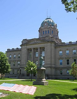
- The current Kankakee courthouse was built from 1909 to 1912 in the Neo-classical Revivalist style in the wake of the 1893 Columbian Exposition (the Chicago World's Fair) as part of the City Beautiful movement. The architect was Zachary Taylor Davis who had previously worked with Frank Lloyd Wright when both worked as draftsmen for Louis Sullivan.
Kankakee River[]

The Kankakee River runs through Kankakee. It is approximately 133 miles long and is a major attraction and is viewed as a defining landmark of Kankakee. The Kankakee River provides the town vital resources and an economic boost. The river water is refined at the Kankakee water company, and electricity is generated at the Kankakee River Dam. The fishing also provides a tourist attraction for outdoors men and women alike.

See also[]
- Kankakee Outwash Plain
- List of people from Kankakee
References[]
- ^ "2019 U.S. Gazetteer Files". United States Census Bureau. Retrieved July 14, 2020.
- ^ Jump up to: a b c "Kankakee". Geographic Names Information System. United States Geological Survey.
- ^ "Annual Estimates of the Resident Population: April 1, 2010 to July 1, 2012". United States Census Bureau. Retrieved August 8, 2013.
- ^ Jump up to: a b "Population and Housing Unit Estimates". United States Census Bureau. May 24, 2020. Retrieved May 27, 2020.
- ^ "Find a County". National Association of Counties. Archived from the original on May 31, 2011. Retrieved June 7, 2011.
- ^ McCafferty, Michael (April 29, 2018). Native American Place Names of Indiana. University of Illinois Press. ISBN 9780252032684. Retrieved April 29, 2018 – via Google Books.
- ^ McCafferty, Michael (April 29, 2018). Native American Place Names of Indiana. University of Illinois Press. ISBN 9780252032684. Retrieved April 29, 2018 – via Google Books.
- ^ Werich, Jacob Lorenzo (April 29, 2018). "Pioneer Hunters of the Kankakee". Chronicle Printing Company. Retrieved April 29, 2018 – via Google Books.
- ^ Bradford, William John Alden (April 29, 2018). Notes on the Northwest: Or, Valley of the Upper Mississippi. Wiley and Putnam. ISBN 9780608438849. Retrieved April 29, 2018 – via Google Books.
- ^ Johnson, Vic. 1994. "L'Riviere Theakiki--'The Fabulous River of 2,000 Bends'", The Daily Journal (July 31, 1994), p. 24.
- ^ Temple, Wayne C. 1958. Indian Villages of the Illinois Country Archived July 4, 2015, at the Wayback Machine. Illinois State Museum Scientific Papers, vol. 2, Part 2, p. 145, fn 104
- ^ Historical Encyclopedia of Illinois and History of Kankakee County , Volume 2, Issue 1, edited by Newton Bateman, Paul Selby ; edited by William F. Kenaga, George R. Letourneau, p. 623.
- ^ "Mound Grove Cemetery". graveyards.com. Archived from the original on April 29, 2018. Retrieved April 29, 2018.
- ^ "US Gazetteer files: 2010, 2000, and 1990". United States Census Bureau. February 12, 2011. Retrieved April 23, 2011.
- ^ "G001 - Geographic Identifiers - 2010 Census Summary File 1". United States Census Bureau. Archived from the original on February 13, 2020. Retrieved December 27, 2015.
- ^ "NowData – NOAA Online Weather Data". National Oceanic and Atmospheric Administration. Retrieved July 13, 2021.
- ^ "Station: Kankakee Metro Wastewater, IL". U.S. Climate Normals 2020: U.S. Monthly Climate Normals (1991-2020). National Oceanic and Atmospheric Administration. Retrieved July 13, 2021.
- ^ "Census of Population and Housing". Census.gov. Retrieved June 4, 2015.
- ^ "U.S. Census website". United States Census Bureau. Retrieved January 31, 2008.
- ^ "Kankakee Valley Airport Authority". Kankakee Valley Airport Authority. Archived from the original on August 16, 2012. Retrieved June 8, 2012.
- ^ "Kankakee, IL (KKI)". Amtrak. Archived from the original on August 25, 2012. Retrieved June 8, 2012.
- ^ "City of New Orleans, Illini and Saluki" (PDF). Amtrak. May 7, 2012. Archived (PDF) from the original on May 11, 2012. Retrieved June 8, 2012.
- ^ "Transfer Stations". River Valley Metro. Archived from the original on October 6, 2011. Retrieved June 8, 2012.
- ^ "US Board on Geographic Names". United States Geological Survey. October 25, 2007. Archived from the original on February 4, 2012. Retrieved January 31, 2008.
- ^ "Geographic Names Information System". United States Geological Survey. Archived from the original on July 14, 2012. Retrieved January 31, 2008.
- ^ "Kankakee School District Schools". Kankakee School District 111. Archived from the original on June 10, 2012. Retrieved June 8, 2012.
- ^ "Kankakee: Name change introduces Grace Christian Academy".
- ^ "Grace Baptist Academy". gracecrusaders.org. Grace Baptist Academy. Archived from the original on March 9, 2012. Retrieved June 8, 2012.
- ^ "Our Purpose". Kankakee Trinity Academy. Archived from the original on May 16, 2012. Retrieved June 8, 2012.
- ^ "Hey, David Letterman: We're polishing our image". daily-journal.com. Retrieved April 29, 2018.
- ^ "Kirkbride Buildings Forum • View topic – Movies Filmed at Kankakee". Kirkbridebuildings.com. April 28, 2008. Archived from the original on September 28, 2011. Retrieved October 17, 2011.
- ^ "Innocent Bessie Brown (5 Oct 1910) Lyrics – Berlin Irving". Songlyrics.com. Retrieved October 17, 2011.
- ^ Sheet Music Art Of Irving Berlin / Thomas Inglis. – Atglen, PA : Schiffer Pub., c2003 (p. 21 & 23)
- ^ The Broadway League. "The official source for Broadway Information". IBDB. Archived from the original on October 24, 2012. Retrieved October 17, 2011.
- ^ "They Are Night Zombies Lyrics – Sufjan Stevens". Songlyrics.com. Retrieved October 17, 2011.
- ^ Christopher, James (July 5, 2005). "Illinois – Sufjan Stevens". AllMusic. Archived from the original on September 8, 2011. Retrieved October 17, 2011.
- ^ "Song Search for "city of new orleans"". AllMusic. Archived from the original on October 23, 2017. Retrieved April 29, 2018.
- ^ Philip Furia, Michael L. Lasser (May 12, 2006). America's songs. p. 160. ISBN 978-0-415-97246-8.
- ^ "554: Not It!". thisamericanlife.org. April 10, 2015. Archived from the original on April 8, 2015.
- ^ The Best Places to Raise a Family. 1997. Reader's Digest, April 1997, pp. 74-81
- ^ "The B. Harley Bradley House". www.kankakeewright.org. Archived from the original on January 15, 2012. Retrieved April 29, 2018.
- ^ Heinz, Thomas A.; Wright, Frank Lloyd (April 29, 2018). Frank Lloyd Wright Field Guide: Includes All United States and International Sites. Northwestern University Press. ISBN 9780810122444. Retrieved April 29, 2018 – via Google Books.
- List of Kankakee Valley Park District Activities and Offerings
- Description of Kankakee from Illinois.com
External links[]
| Wikivoyage has a travel guide for Kankakee. |
| Wikisource has the text of a 1905 New International Encyclopedia article about "Kankakee, Illinois". |
- City of Kankakee, Historical Encyclopedia of Illinois, Volume 2 by Newton Bateman
- . Encyclopædia Britannica. 13 (9th ed.). 1881.
- Official City page
- Kankakee Regional Chamber of Commerce
- St. Joseph-Kankakee Portage--Its Location and Use by Marquette, La Salle and the French Voyageurs by George A. Baker, 1899, page 11
- "Kankakee Knows What's Coming," Life magazine, vol. 30, no. 1, January 1, 1951
| show Municipalities and communities of Kankakee County, Illinois, United States |
|---|
| show Chicago metropolitan area |
|---|

| show Authority control |
|---|
- Kankakee, Illinois
- Cities in Illinois
- Cities in Kankakee County, Illinois
- County seats in Illinois
- Metropolitan areas of Illinois
- 1865 establishments in Illinois