Mount Carroll, Illinois
Mount Carroll | |
|---|---|
City | |
 | |
| Etymology: Named for Charles Carroll of Carrollton, a signer of the Declaration of Independence | |
| Motto(s): Where we take the time to care | |
 Location of Mount Carroll in Carroll County, Illinois. | |
 Location of Illinois in the United States | |
| Coordinates: 42°05′44″N 89°58′37″W / 42.09556°N 89.97694°WCoordinates: 42°05′44″N 89°58′37″W / 42.09556°N 89.97694°W | |
| Country | United States |
| State | Illinois |
| County | Carroll |
| Government | |
| • Mayor | Carl Bates |
| Area | |
| • Total | 2.00 sq mi (5.19 km2) |
| • Land | 2.00 sq mi (5.19 km2) |
| • Water | 0.00 sq mi (0.00 km2) |
| Elevation | 810 ft (250 m) |
| Population (2010) | |
| • Total | 1,717 |
| • Estimate (2019)[3] | 1,571 |
| • Density | 784.32/sq mi (302.77/km2) |
| Time zone | UTC-6 (CST) |
| • Summer (DST) | UTC-5 (CDT) |
| ZIP Code(s) | 61053 |
| Area code(s) | 815 |
| FIPS code | 17-50881 |
| Wikimedia Commons | Mount Carroll, Illinois |
| Website | www |

Mount Carroll is a city in Carroll County, Illinois, United States. It is the Carroll County seat. The population was 1,717 at the 2010 census and as of 2018, the population had dropped to an estimated 1,587.[4][5]
Due to its elevation and northwesterly location, Mount Carroll is subject to unusually cold winter weather. From 1930 to 1999, Mount Carroll held the record for the lowest temperature ever recorded in Illinois, −35 °F (−37 °C), recorded on January 22, 1930.[6][7] The record was beaten by Congerville in 1999, by one degree Fahrenheit. 20 years later, on January 31, 2019 during an extreme cold snap, Mount Carroll regained the title of coldest city in Illinois when a new Illinois state record low temperature of −38 °F (−39 °C) was officially recorded.[8]
History[]

Mount Carroll began life as a mill town around 1841. In 1843, a referendum moved the county seat from nearby Savanna to Mount Carroll. The town was incorporated in 1855 and became a city in 1867; the first mayor was Nathaniel Halderman, a prominent local businessman and co-founder of the mill.[9]
Shimer College was established in Mt. Carroll in 1853, but mounting debts forced a move to Waukegan in 1979 and subsequently to Chicago in 2006. The campus now is home to several organizations, most notably the Campbell Center for Historic Preservation Studies.
Political scientist Robert Keohane grew up in Mt. Carroll before attending Shimer.
Geography[]
Mount Carroll is located slightly northwest of the center of Carroll County at 42°5′44″N 89°58′37″W / 42.09556°N 89.97694°W (42.095473, -89.977042).[10] U.S. Route 52 passes through the southern part of the city, leading east 7 miles (11 km) to Lanark and west 10 miles (16 km) to Savanna on the Mississippi River.
According to the 2010 census, Mount Carroll has a total area of 2.02 square miles (5.23 km2), all land.[11]
Climate[]
| hideClimate data for Mount Carroll, Illinois (1991–2020 normals, extremes 1897–present) | |||||||||||||
|---|---|---|---|---|---|---|---|---|---|---|---|---|---|
| Month | Jan | Feb | Mar | Apr | May | Jun | Jul | Aug | Sep | Oct | Nov | Dec | Year |
| Record high °F (°C) | 61 (16) |
73 (23) |
85 (29) |
92 (33) |
104 (40) |
104 (40) |
108 (42) |
103 (39) |
99 (37) |
91 (33) |
79 (26) |
69 (21) |
108 (42) |
| Average high °F (°C) | 30.7 (−0.7) |
35.3 (1.8) |
47.5 (8.6) |
60.6 (15.9) |
72.3 (22.4) |
81.7 (27.6) |
84.9 (29.4) |
83.3 (28.5) |
76.9 (24.9) |
63.9 (17.7) |
48.5 (9.2) |
35.8 (2.1) |
60.1 (15.6) |
| Daily mean °F (°C) | 20.8 (−6.2) |
24.8 (−4.0) |
36.6 (2.6) |
48.2 (9.0) |
59.8 (15.4) |
69.4 (20.8) |
72.6 (22.6) |
70.7 (21.5) |
63.3 (17.4) |
51.1 (10.6) |
38.0 (3.3) |
26.4 (−3.1) |
48.5 (9.2) |
| Average low °F (°C) | 10.9 (−11.7) |
14.3 (−9.8) |
25.7 (−3.5) |
35.8 (2.1) |
47.3 (8.5) |
57.0 (13.9) |
60.4 (15.8) |
58.1 (14.5) |
49.6 (9.8) |
38.3 (3.5) |
27.4 (−2.6) |
17.1 (−8.3) |
36.8 (2.7) |
| Record low °F (°C) | −38 (−39) |
−36 (−38) |
−16 (−27) |
2 (−17) |
15 (−9) |
31 (−1) |
35 (2) |
32 (0) |
14 (−10) |
4 (−16) |
−15 (−26) |
−28 (−33) |
−38 (−39) |
| Average precipitation inches (mm) | 1.66 (42) |
1.83 (46) |
2.51 (64) |
3.90 (99) |
4.57 (116) |
5.49 (139) |
4.89 (124) |
3.91 (99) |
3.71 (94) |
3.02 (77) |
2.60 (66) |
2.21 (56) |
40.30 (1,024) |
| Average snowfall inches (cm) | 10.2 (26) |
7.9 (20) |
3.6 (9.1) |
0.8 (2.0) |
0.0 (0.0) |
0.0 (0.0) |
0.0 (0.0) |
0.0 (0.0) |
0.0 (0.0) |
0.4 (1.0) |
1.7 (4.3) |
8.8 (22) |
33.4 (85) |
| Average precipitation days (≥ 0.01 in) | 8.9 | 7.6 | 8.9 | 11.4 | 12.7 | 11.6 | 8.9 | 8.7 | 8.6 | 8.7 | 8.1 | 9.2 | 113.3 |
| Average snowy days (≥ 0.1 in) | 5.2 | 4.2 | 1.9 | 0.3 | 0.0 | 0.0 | 0.0 | 0.0 | 0.0 | 0.2 | 0.8 | 4.7 | 17.3 |
| Source: NOAA[12][13] | |||||||||||||
Arts and culture[]
Mount Carroll enjoys a remarkable concentration of historically and architecturally significant structures. The bulk of the town's downtown and older residential area are included in the Mount Carroll Historic District, which encompasses 118 acres (48 ha) and was entered into the National Register of Historic Places in 1980. Mount Carroll is also home to the Campbell Center for Historic Preservation Studies, located on the historic former Shimer College campus near the south edge of town.
The Timber Lake Playhouse, the oldest semiprofessional summer stock theater company in Illinois, is located 4 miles (6 km) southeast of Mount Carroll. The Mount Carroll post office contains an oil on canvas mural, Rural Scene - Wakarusa Valley, painted by Irene Bianucci in 1941. Federally commissioned murals were produced from 1934 to 1943 in the United States through the Section of Painting and Sculpture, later called the Section of Fine Arts, of the Treasury Department.[14]
Demographics[]
| Historical population | |||
|---|---|---|---|
| Census | Pop. | %± | |
| 1850 | 462 | — | |
| 1860 | 1,323 | 186.4% | |
| 1870 | 1,756 | 32.7% | |
| 1890 | 1,836 | — | |
| 1900 | 1,965 | 7.0% | |
| 1910 | 1,759 | −10.5% | |
| 1920 | 1,806 | 2.7% | |
| 1930 | 1,775 | −1.7% | |
| 1940 | 1,845 | 3.9% | |
| 1950 | 1,950 | 5.7% | |
| 1960 | 2,056 | 5.4% | |
| 1970 | 2,143 | 4.2% | |
| 1980 | 1,936 | −9.7% | |
| 1990 | 1,726 | −10.8% | |
| 2000 | 1,832 | 6.1% | |
| 2010 | 1,717 | −6.3% | |
| 2019 (est.) | 1,571 | [3] | −8.5% |
| U.S. Decennial Census[15] | |||
As of the census[16] of 2000, there were 1,832 people, 765 households, and 501 families residing in the city. The population density was 963.5 people per square mile (372.3/km2). There were 855 housing units at an average density of 449.7 per square mile (173.7/km2). The racial makeup of the city was 98.53% White, 0.16% African American, 0.27% Native American, 0.27% Asian, 0.33% from other races, and 0.44% from two or more races. Hispanic or Latino of any race were 1.31% of the population.
There were 765 households, out of which 29.0% had children under the age of 18 living with them, 54.4% were married couples living together, 8.0% had a female householder with no husband present, and 34.5% were non-families. 31.4% of all households were made up of individuals, and 17.0% had someone living alone who was 65 years of age or older. The average household size was 2.35 and the average family size was 2.94.
In the city, the population was spread out, with 24.4% under the age of 18, 7.9% from 18 to 24, 26.0% from 25 to 44, 21.9% from 45 to 64, and 19.7% who were 65 years of age or older. The median age was 40 years. For every 100 females, there were 95.9 males. For every 100 females age 18 and over, there were 88.7 males.
The median income for a household in the city was $34,861, and the median income for a family was $40,511. Males had a median income of $29,292 versus $22,212 for females. The per capita income for the city was $16,455. About 5.1% of families and 8.5% of the population were below the poverty line, including 12.5% of those under age 18 and 4.3% of those age 65 or over.
Notable people[]
- Samuel James Campbell, banker and philanthropist, born in Mount Carroll
- Felix A. Kremer, Wisconsin State Assemblyman, born in Mount Carroll
- John L. Griffith, college coach, first commissioner of the Big Ten Conference
- Howard Kyle (née Vandergrift), noted actor, Union School class of 1879 valedictorian
- Suzanna W. Miles, archaeologist, anthropologist, ethnohistorian and Mayanist, born in Mount Carroll
- Ward Miller, outfielder for five Major League Baseball teams; born in Mount Carroll
- James Shaw, Illinois state representative, lawyer, judge, and geologist, practices law in Mount Carroll
- Neta Snook, pioneer woman aviator and aviation instructor
- Emmert L. Wingert, Wisconsin Supreme Court justice, born in Mount Carroll
Notable Shimer students in Mount Carroll[]
- Robert Keohane, political scientist, grew up in Mt. Carroll before attending Shimer
- Daniel Perlman, president of Suffolk University and later president of Webster University
- Phoebe Snow, singer, songwriter, and guitarist, best known for her chart-topping 1975 hit "Poetry Man"
- Laurie Spiegel, composer whose most recent accolades are her work in the movie The Hunger Games
- Mary Wings, writer, artist, and musician
- Catherine Yronwode, writer, editor, graphic designer, typesetter, publisher with an extensive career in the comic book industry
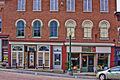
Photos[]

Downtown Market Street

Downtown Market Street
Downtown Market Street
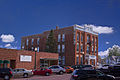
Downtown hotel

Downtown Main Street


References[]
- ^ "2019 U.S. Gazetteer Files". United States Census Bureau. Retrieved July 14, 2020.
- ^ "USGS detail on Newtown". Retrieved 2007-10-21.
- ^ Jump up to: a b "Population and Housing Unit Estimates". United States Census Bureau. May 24, 2020. Retrieved May 27, 2020.
- ^ "Geographic Identifiers: 2010 Demographic Profile Data (G001): Mount Carroll city, Illinois". U.S. Census Bureau, American Factfinder. Archived from the original on February 12, 2020. Retrieved July 31, 2014.
- ^ "ACS DEMOGRAPHIC AND HOUSING ESTIMATES". data.census.gov. Retrieved 2020-04-02.
- ^ Paul T. Hellman (2013). "Mount Carroll". Historical Gazetteer of the United States. p. 293. ISBN 978-1135948597.
- ^ Hilyard, Scott (February 28, 2019). "Congerville about to lose its extreme cold state record". PJStar.com. Peoria, Illinois. Retrieved May 1, 2019.
- ^ "Illinois State Record Minimum Temperature at Mt. Carroll" (PDF). National Centers for Environmental Information. National Oceanic and Atmospheric Administration. March 5, 2019. Retrieved May 1, 2019.
- ^ History of Carroll County. 1878. p. 358.
- ^ "US Gazetteer files: 2010, 2000, and 1990". United States Census Bureau. 2011-02-12. Retrieved 2011-04-23.
- ^ "G001 - Geographic Identifiers - 2010 Census Summary File 1". United States Census Bureau. Archived from the original on 2020-02-13. Retrieved 2015-12-27.
- ^ "NowData – NOAA Online Weather Data". National Oceanic and Atmospheric Administration. Retrieved July 11, 2021.
- ^ "Station: MT Carroll, IL". U.S. Climate Normals 2020: U.S. Monthly Climate Normals (1991-2020). National Oceanic and Atmospheric Administration. Retrieved July 11, 2021.
- ^ "Post Office Mural". livingnewdeal.org. Living New Deal. Retrieved 13 June 2016.
- ^ "Census of Population and Housing". Census.gov. Retrieved June 4, 2015.
- ^ "U.S. Census website". United States Census Bureau. Retrieved 2008-01-31.
External links[]
| Wikimedia Commons has media related to Mount Carroll, Illinois. |
- City of Mount Carroll official website
- Mount Carroll visitors guide
- Mount Carroll Community Development Corporation
| show Municipalities and communities of Carroll County, Illinois, United States |
|---|
| show Authority control |
|---|
- Cities in Carroll County, Illinois
- Cities in Illinois
- County seats in Illinois
- 1841 establishments in Illinois
- Populated places established in 1841