L'Étang-Salé
L'Étang-Salé | |
|---|---|
 Beach of L'Étang-Salé | |
 Coat of arms | |
 | |
show Location of L'Étang-Salé | |
| Coordinates: 21°15′58″S 55°22′01″E / 21.2661°S 55.3669°ECoordinates: 21°15′58″S 55°22′01″E / 21.2661°S 55.3669°E | |
| Country | France |
| Overseas region and department | Réunion |
| Arrondissement | Saint-Pierre |
| Canton | L'Étang-Salé |
| Intercommunality | Villes solidaires |
| Government | |
| • Mayor (2020–2026) | Jean-Claude Lacouture[1] |
| Area 1 | 38.65 km2 (14.92 sq mi) |
| Population (Jan. 2018)[2] | 14,108 |
| • Density | 370/km2 (950/sq mi) |
| Time zone | UTC+04:00 |
| INSEE/Postal code | 97404 /97427 |
| Elevation | 0–1,781 m (0–5,843 ft) (avg. 31 m or 102 ft) |
| 1 French Land Register data, which excludes lakes, ponds, glaciers > 1 km2 (0.386 sq mi or 247 acres) and river estuaries. | |


L'Étang-Salé (French for The Salty Pond) is a commune in the department and region of Réunion. It is bordered by the communes of Les Avirons and Saint-Louis. Within the commune is the Étang-Salé forest. There is also a beach with black sand in the commune that is a popular surfing spot.
Demography[]
| Year | Pop. | ±% p.a. |
|---|---|---|
| 1967 | 6,510 | — |
| 1974 | 6,610 | +0.22% |
| 1982 | 7,479 | +1.56% |
| 1990 | 8,769 | +2.01% |
| 1999 | 11,755 | +3.31% |
| 2007 | 13,179 | +1.44% |
| 2012 | 13,647 | +0.70% |
| 2017 | 13,894 | +0.36% |
| Source: INSEE[3] | ||
Economy and tourism[]
- there is an industrial zone in L'Étang-Salé
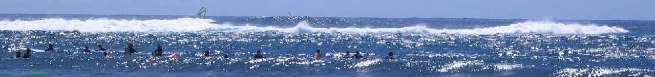
- a popular surfing beach in L'Étang-Salé-les-Bains
- several hotels
- an 18-hole golf course
- Croc' Park - a crocodile park
Images[]
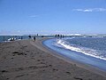
The beach of L'Étang-Salé

Surfer at L'Étang-Salé

Forest of L'Étang-Salé

The Gouffre - a lava formation at the coast


See also[]
References[]
- ^ "Répertoire national des élus: les maires". data.gouv.fr, Plateforme ouverte des données publiques françaises (in French). 2 December 2020. Retrieved 8 December 2020.
- ^ "Populations légales 2018". INSEE. 28 December 2020.
- ^ Population en historique depuis 1968, INSEE
External links[]
| Wikimedia Commons has media related to L'Étang-Salé. |
This Réunion location article is a stub. You can help Wikipedia by . |
Categories:
- Communes of Réunion
- Surfing locations in Réunion
- Réunion geography stubs