Lancelin, Western Australia
| Lancelin Western Australia | |
|---|---|
 View of the Indian Ocean, south of the Lancelin pier. | |
 Lancelin | |
| Coordinates | 31°00′50″S 115°19′48″E / 31.014°S 115.33°ECoordinates: 31°00′50″S 115°19′48″E / 31.014°S 115.33°E |
| Population | 726 (2016 census)[1] |
| Postcode(s) | 6044 |
| Elevation | 6 m (20 ft) |
| Location |
|
| LGA(s) | Shire of Gingin |
| State electorate(s) | Moore |
| Federal division(s) | Pearce |

Lancelin is a small fishing and tourist town 127 km north of Perth, Western Australia. It is within the Shire of Gingin at the end of Wanneroo Road (State Route 60), and a few kilometres from the start of the Indian Ocean Drive.
Lancelin is close to the shipwreck site of the Vergulde Draeck or Gilt Dragon that was wrecked on rocks close to shore in 1656.[2] The town has a permanent population of over 600, and swells to 2,500 during the peak holiday period around Christmas and New Year.
History[]
The town's name originates from nearby Lancelin Island which was named after P.J. Lancelin the scientific writer by Captain Nicolas Baudin in 1801 during the Frenchman's expedition.[3]
The area was initially a holiday camping place through the 1940s and holiday shacks were probably built in the area during this time, but interest in the area grew as it was designated as a possible port to be utilised by the crayfish or lobster fishery.
Lancelin was gazetted in 1950 and was originally named "Wangaree", the Aboriginal word for fish. The area was renamed in 1953 after a request from the Gingin Road Board.[4]
On 29 June 1974, two sounding rockets for solar research during a total solar eclipse were launched from Lancelin.[5]
The Australian military has used the to the north of the town for training exercises since the 1940s.[6][7]
Recreational[]
Two islands are located just off the coast in the bay; Edwards Island and Lancelin Island.
Lancelin Island Nature Reserve (500 metres offshore) is managed for the conservation of flora and fauna. The island is an important sanctuary for a variety of breeding seabirds, for several resident landbirds and lizards and for resting sea lions. A variety of marine, wading and land birds may be observed. You can go to this island by boat and it is a popular summer trip. There is a walkway along the island that visitors can walk on to see the wildlife.
Edwards island is prohibited to travel to since it is high class nature reserve.
Kitesurfing and windsurfing are popular in the ocean off Lancelin. Sandboarding and riding on a dune buggy, motorbike or four-wheel drive are popular on the beaches and on the dunes behind the town.
Every March the annual colour blast event is held on the beach.[8]
The Lancelin District Community Association is the holder of the Guinness World Record for the largest off-road convoy.[9]
Climate[]
Lancelin has a hot-summer mediterranean climate that is consistently warm throughout the year, resembling a typical subtropical climate but with a dry summer.
| Climate data for Lancelin | |||||||||||||
|---|---|---|---|---|---|---|---|---|---|---|---|---|---|
| Month | Jan | Feb | Mar | Apr | May | Jun | Jul | Aug | Sep | Oct | Nov | Dec | Year |
| Record high °C (°F) | 46.0 (114.8) |
45.3 (113.5) |
43.6 (110.5) |
37.5 (99.5) |
32.0 (89.6) |
29.4 (84.9) |
27.7 (81.9) |
29.0 (84.2) |
32.4 (90.3) |
39.0 (102.2) |
40.7 (105.3) |
43.2 (109.8) |
46.0 (114.8) |
| Average high °C (°F) | 29.2 (84.6) |
30.0 (86.0) |
28.5 (83.3) |
25.5 (77.9) |
22.7 (72.9) |
20.2 (68.4) |
19.2 (66.6) |
19.3 (66.7) |
20.5 (68.9) |
22.5 (72.5) |
24.9 (76.8) |
27.3 (81.1) |
24.2 (75.6) |
| Average low °C (°F) | 17.6 (63.7) |
18.1 (64.6) |
16.7 (62.1) |
14.6 (58.3) |
12.4 (54.3) |
10.8 (51.4) |
9.9 (49.8) |
9.9 (49.8) |
10.5 (50.9) |
11.9 (53.4) |
14.1 (57.4) |
16.2 (61.2) |
13.6 (56.5) |
| Record low °C (°F) | 8.6 (47.5) |
8.3 (46.9) |
6.3 (43.3) |
4.4 (39.9) |
3.3 (37.9) |
1.6 (34.9) |
1.5 (34.7) |
0.1 (32.2) |
1.0 (33.8) |
3.2 (37.8) |
4.4 (39.9) |
4.4 (39.9) |
0.1 (32.2) |
| Average precipitation mm (inches) | 8.9 (0.35) |
12.0 (0.47) |
14.1 (0.56) |
30.8 (1.21) |
82.6 (3.25) |
119.5 (4.70) |
120.7 (4.75) |
91.1 (3.59) |
56.4 (2.22) |
28.9 (1.14) |
20.9 (0.82) |
8.2 (0.32) |
592.3 (23.32) |
| Average precipitation days | 2.0 | 2.1 | 3.5 | 7.0 | 12.0 | 15.4 | 16.6 | 15.4 | 12.6 | 8.2 | 5.4 | 3.0 | 103.2 |
| Average relative humidity (%) | 61 | 60 | 60 | 62 | 61 | 63 | 65 | 64 | 64 | 62 | 62 | 61 | 62 |
| Source: [10] | |||||||||||||
Gallery[]
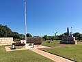
Lancelin War Memorial
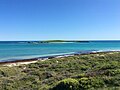
Lancelin Island viewed from the lookout

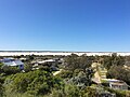
View from Lancelin Lookout southward towards the town centre and the jetty
Sand dunes to the northeast of Lancelin viewed from the lookout
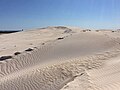
Lancelin sand dunes


References[]
- ^ Australian Bureau of Statistics (31 October 2012). "Lancelin (L) (Urban Centre/Locality)". 2011 Census QuickStats. Retrieved 28 October 2012.

- ^ "Life on Perth - Lancelin coastline". 2008. Retrieved 20 September 2008.
- ^ "50 Western Australian Facts and Trivia" (PDF). 2008. Archived from the original (PDF) on 21 July 2008. Retrieved 20 September 2008.
- ^ Western Australian Land Information Authority. "History of country town names – L". Retrieved 20 September 2008.
- ^ Lancelin, Encyclopedia Astronautica
- ^ "Lancelin Training Area" (PDF). Department of Defence. Retrieved 3 March 2018.
- ^ "Lancelin Defence Training Area". Australian Defence Facilities. Nautilus Institute. 22 April 2012. Retrieved 3 March 2018.
- ^ "Rainbow explosion at Lancelin Beach for Colour Blast". 4 March 2017.
- ^ "Largest convoy of off-road vehicles".
- ^ "Climate statistics for Lancelin". Bureau of Meteorology. Retrieved 2 September 2014.
External links[]
| Wikimedia Commons has media related to Lancelin, Western Australia. |
- Towns in Western Australia
- Wheatbelt (Western Australia)
- Coastal towns in Western Australia
- Fishing communities in Australia
- Shire of Gingin