Wialki, Western Australia
| Wialki Western Australia | |
|---|---|
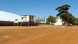 Wialki grain receival point, 2014 | |
 Wialki | |
| Coordinates | 30°28′35″S 118°07′18″E / 30.47639°S 118.12167°ECoordinates: 30°28′35″S 118°07′18″E / 30.47639°S 118.12167°E |
| Population | 29 (2016 census)[1] |
| Established | 1933 |
| Postcode(s) | 6473 |
| Elevation | 414 m (1,358 ft) |
| Location | |
| LGA(s) | Shire of Mount Marshall |
| State electorate(s) | Central Wheatbelt |
| Federal division(s) | Durack |

Wialki is a townsite in the eastern Wheatbelt region of Western Australia. It is situated between Beacon and Bonnie Rock.
Wialki was originally a siding on the Burakin to Bonnie Rock railway extension planned to pass through the area in 1929; the district surveyor suggested the station should be named Datjoin but the Railway department chose the name Wialki after the Aboriginal name of a nearby soak. The station was named in 1930 and the townsite was gazetted in 1933.[2] The surrounding areas produce wheat and other cereal crops. A second bulk wheat bin was constructed in town in 1940 just as the first bulk bin was filled.[3] The town is a receival site for Cooperative Bulk Handling.[4]
References[]
- ^ Australian Bureau of Statistics (27 June 2017). "Wialki (State Suburb)". 2016 Census QuickStats. Retrieved 20 May 2019.

- ^ "History of country town names – W". Western Australian Land Information Authority. Retrieved 20 April 2011.
- ^ "Country news". The West Australian. Perth: National Library of Australia. 17 January 1940. p. 3. Retrieved 3 April 2013.
- ^ "CBH receival sites" (PDF). 2011. Retrieved 20 April 2011.
External links[]
![]() Media related to Wialki, Western Australia at Wikimedia Commons
Media related to Wialki, Western Australia at Wikimedia Commons
- Towns in Western Australia
- Wheatbelt (Western Australia)
- Grain receival points of Western Australia