Shire of Mount Marshall
| Shire of Mount Marshall Western Australia | |||||||||||||||
|---|---|---|---|---|---|---|---|---|---|---|---|---|---|---|---|
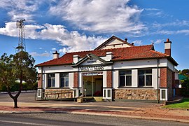 Mount Marshall Shire Hall, Bencubbin, 2018 | |||||||||||||||
 Location in Western Australia | |||||||||||||||
| Population | 527 (2016 census)[1] | ||||||||||||||
| • Density | 0.06/km2 (0.16/sq mi) | ||||||||||||||
| Established | 1923 | ||||||||||||||
| Area | 10,189.5 km2 (3,934.2 sq mi) | ||||||||||||||
| Mayor | Rachel Kirby | ||||||||||||||
| Council seat | Bencubbin | ||||||||||||||
| Region | Wheatbelt | ||||||||||||||
| State electorate(s) | Central Wheatbelt | ||||||||||||||
| Federal Division(s) | Durack | ||||||||||||||
| Website | Shire of Mount Marshall | ||||||||||||||
| |||||||||||||||
The Shire of Mount Marshall is a local government area in the Wheatbelt region of Western Australia, about 80 kilometres (50 mi) north-northwest of Merredin and about 300 kilometres (186 mi) northeast of the state capital, Perth. The Shire covers an area of 10,190 square kilometres (3,934 sq mi), and its seat of government is the town of Bencubbin.
History[]
The area was first explored by Surveyor General John Septimus Roe, Mount Marshall and Lake McDermott were named after early Swan River Colony settler Marshall McDermott, cashier of the Bank of Western Australia, magistrate, and a director of the Agricultural Society of Western Australia.[2][3][4] The area was first settled by sandalwood collectors and graziers in 1868. Sandalwood was removed from this area from the 1880s until the 1920s. Permanent settlement and the development and clearing of the land for farms commenced around 1910.
The Mount Marshall Road District was established on 6 July 1923 from areas formerly falling within the Ninghan Road District and Nungarin Road District. On 1 July 1961, it became a shire following the passage of the Local Government Act 1960, which reformed all remaining road districts into shires.[5]
Wards[]
The Shire has no wards and each Councillor represents the entire district of the Shire of Mt Marshall as required by the Local Government Act 1995.
Towns and localities[]
Heritage-listed places[]
As of 2021, 50 places are heritage-listed in the Shire of Mount Marshall,[6] of which none are on the State Register of Heritage Places.[7]
References[]
- ^ Australian Bureau of Statistics (27 June 2017). "Mount Marshall (S)". 2016 Census QuickStats. Retrieved 1 December 2017.

- ^ "Public meeting". The Perth Gazette and Western Australian Journal. 9 January 1836. p. 630. Retrieved 19 October 2020.
- ^ "The Swan River Guardian". Swan River Guardian (57). Perth, WA. 4 January 1838. p. 176. Retrieved 19 October 2020.
- ^ "Government Notice". The Perth Gazette and Western Australian Journal (259). 16 December 1837. p. 1032. Retrieved 19 October 2020.
- ^ "Municipality Boundary Amendments Register" (PDF). Western Australian Electoral Distribution Commission. Retrieved 11 January 2020.
- ^ "Shire of Mount Marshall Heritage Places". inherit.stateheritage.wa.gov.au. Heritage Council of Western Australia. Retrieved 27 March 2021.
- ^ "Shire of Mount Marshall State Register of Heritage Places". inherit.stateheritage.wa.gov.au. Heritage Council of Western Australia. Retrieved 27 March 2021.
External links[]
| Authority control |
|
|---|

- Populated places established in 1923
- 1923 establishments in Australia
- Local government areas of the Wheatbelt region of Western Australia