Shire of Upper Gascoyne
| Shire of Upper Gascoyne Western Australia | |||||||||||||||
|---|---|---|---|---|---|---|---|---|---|---|---|---|---|---|---|
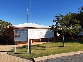 The Shire of Upper Gascoyne administration office | |||||||||||||||
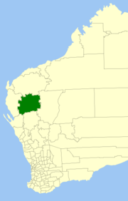 Location in Western Australia | |||||||||||||||
| Population | 278 (2016 census)[1] | ||||||||||||||
| • Density | 0.004798/km2 (0.012427/sq mi) | ||||||||||||||
| Established | 1887 | ||||||||||||||
| Area | 57,939 km2 (22,370.4 sq mi) | ||||||||||||||
| Shire President | Don Hammmarquist | ||||||||||||||
| Council seat | Gascoyne Junction | ||||||||||||||
| Region | Gascoyne region | ||||||||||||||
| State electorate(s) | North West | ||||||||||||||
| Federal division(s) | Durack | ||||||||||||||
| Website | Shire of Upper Gascoyne | ||||||||||||||
| |||||||||||||||
The Shire of Upper Gascoyne is a local government area in the Gascoyne region of Western Australia, inland from Carnarvon and about 1,000 kilometres (620 mi) north of the state capital, Perth. The Shire has an area of 57,939 square kilometres (22,370 sq mi), much of which is uninhabited land or sparsely vegetated sheep station country, and its seat of government is the small town of Gascoyne Junction. It has a population of 278 (2016 census), 58% of whom identify as Aboriginal.[1]
History[]
The Upper Gascoyne Road District was gazetted on 10 February 1887. On 1 July 1961, it became a Shire under the Local Government Act 1960, which reformed all remaining road districts into shires.[2] The original Road Board office is now a heritage-listed site.[3]
Wards[]
The shire is divided into 3 wards, each with two councillors:
- North Ward
- South Ward
- East Ward
Towns[]
- Burringurrah
- Gascoyne Junction
- Mount Augustus
Notable councillors[]
- Everard Darlot, Upper Gascoyne Road Board member 1887; later a state MP
- Lionel Kelly, Upper Gascoyne Road Board member 1927–1928; later a state MP
Heritage-listed places[]
As of 2021, 19 places are heritage-listed in the Shire of Upper Gascoyne,[4] of which one is on the State Register of Heritage Places, the Upper Gascoyne Road Board Office in Gascoyne Junction.[5]
References[]
- ^ a b Australian Bureau of Statistics (27 June 2017). "Upper Gascoyne (S)". 2016 Census QuickStats. Retrieved 28 October 2019.

- ^ "Municipality Boundary Amendments Register" (PDF). Western Australian Electoral Distribution Commission. Retrieved 11 January 2020.
- ^ Heritage Council of WA. "Register of Heritage Places - Upper Gascoyne Road Board Office (fmr)" (PDF). Archived from the original (PDF) on 23 August 2006. Retrieved 15 November 2006.
- ^ "Shire of Upper Gascoyne Heritage Places". inherit.stateheritage.wa.gov.au. Heritage Council of Western Australia. Retrieved 6 March 2021.
- ^ "Shire of Upper Gascoyne State Register of Heritage Places". inherit.stateheritage.wa.gov.au. Heritage Council of Western Australia. Retrieved 6 March 2021.
External links[]

- Populated places established in 1887
- 1887 establishments in Australia
- Shire of Upper Gascoyne
- Local government areas of the Gascoyne region of Western Australia