Shire of Katanning
| Shire of Katanning Western Australia | |||||||||||||||
|---|---|---|---|---|---|---|---|---|---|---|---|---|---|---|---|
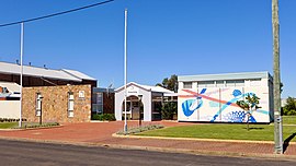 Katanning shire offices, 2018 | |||||||||||||||
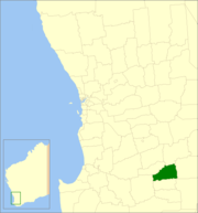 Location in Western Australia | |||||||||||||||
| Population | 4,151 (2016 census)[1] | ||||||||||||||
| • Density | 2.7336/km2 (7.0800/sq mi) | ||||||||||||||
| Established | 1892 | ||||||||||||||
| Area | 1,518.5 km2 (586.3 sq mi) | ||||||||||||||
| President | Liz Guidera | ||||||||||||||
| Council seat | Katanning | ||||||||||||||
| Region | Great Southern | ||||||||||||||
| State electorate(s) | Roe | ||||||||||||||
| Federal Division(s) | O'Connor | ||||||||||||||
| Website | Shire of Katanning | ||||||||||||||
| |||||||||||||||
The Shire of Katanning is a local government area in the Great Southern region of Western Australia, about 170 kilometres (106 mi) north of Albany and about 290 kilometres (180 mi) southeast of the state capital, Perth. The Shire covers an area of 1,518 square kilometres (586 sq mi), and its seat of government is the town of Katanning.
History[]
The Katanning Road District was gazetted on 18 May 1892. On 1 July 1961, it became a Shire following the passage of the Local Government Act 1960, which reformed all remaining road districts into shires.[2]
Towns and localities[]
- Katanning
- Badgebup
- Ewlyamartup
- Moojebing
- Murdong
Notable councillors[]
- Frederick Piesse, Katanning Road Board member 1889–1896; later a state MP
- Wesley Maley, Katanning Road Board chairman 1898; later a state MP
- Arnold Piesse, Katanning Road Board chairman for 11 years; later a state MP
- Alec Thomson, Katanning Road Board member 1911–1915, chairman 1913; later a state MP
Heritage-listed places[]
As of 2021, 121 places are heritage-listed in the Shire of Katanning,[3] of which 19 are on the State Register of Heritage Places.[4]
References[]
Notes[]
- ^ Australian Bureau of Statistics (27 June 2017). "Katanning (S)". 2016 Census QuickStats. Retrieved 28 October 2019.

- ^ "Municipality Boundary Amendments Register" (PDF). Western Australian Electoral Distribution Commission. Retrieved 11 January 2020.
- ^ "Shire of Katanning Heritage Places". inherit.stateheritage.wa.gov.au. Heritage Council of Western Australia. Retrieved 13 March 2021.
- ^ "Shire of Katanning State Register of Heritage Places". inherit.stateheritage.wa.gov.au. Heritage Council of Western Australia. Retrieved 13 March 2021.
Bibliography[]
- Bignell, Merle (1981). A Place to Meet: a History of the Shire of Katanning Western Australia. Nedlands, WA: University of Western Australia Press for the Shire of Katanning. ISBN 0855642025.
External links[]
| Authority control |
|
|---|

Categories:
- Populated places established in 1892
- 1892 establishments in Australia
- Local government areas of the Great Southern region of Western Australia
- Katanning, Western Australia