Landifay-et-Bertaignemont
From Wikipedia, the free encyclopedia
show This article may be expanded with text translated from the corresponding article in French. (December 2008) Click [show] for important translation instructions.
|
Commune in Hauts-de-France, France
Landifay-et-Bertaignemont | |
|---|---|
Commune | |
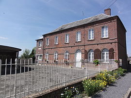 The town hall of Landifay-et-Bertaignemont | |
 Landifay-et-Bertaignemont  Landifay-et-Bertaignemont | |
Coordinates:  49°49′04″N 3°36′25″E / 49.8178°N 3.6069°E / 49.8178; 3.6069Coordinates: 49°49′04″N 3°36′25″E / 49.8178°N 3.6069°E / 49.8178; 3.6069 49°49′04″N 3°36′25″E / 49.8178°N 3.6069°E / 49.8178; 3.6069Coordinates: 49°49′04″N 3°36′25″E / 49.8178°N 3.6069°E / 49.8178; 3.6069 | |
| Country | France |
| Region | Hauts-de-France |
| Department | Aisne |
| Arrondissement | Vervins |
| Canton | Marle |
| Intercommunality | Thiérache du Centre |
| Government | |
| • Mayor (2008–2014) | Philippe Brault |
| Area 1 | 19.6 km2 (7.6 sq mi) |
| Population (Jan. 2018)[1] | 263 |
| • Density | 13/km2 (35/sq mi) |
| Time zone | UTC+01:00 (CET) |
| • Summer (DST) | UTC+02:00 (CEST) |
| INSEE/Postal code | 02403 /02120 |
| Elevation | 77–153 m (253–502 ft) (avg. 113 m or 371 ft) |
| 1 French Land Register data, which excludes lakes, ponds, glaciers > 1 km2 (0.386 sq mi or 247 acres) and river estuaries. | |

Landifay-et-Bertaignemont is a commune in the Aisne department in Hauts-de-France in northern France.
Population[]
| Year | Pop. | ±% |
|---|---|---|
| 1962 | 512 | — |
| 1968 | 482 | −5.9% |
| 1975 | 389 | −19.3% |
| 1982 | 339 | −12.9% |
| 1990 | 312 | −8.0% |
| 1999 | 277 | −11.2% |
| 2008 | 299 | +7.9% |
See also[]
References[]
- ^ "Populations légales 2018". INSEE. 28 December 2020.
| Wikimedia Commons has media related to Landifay-et-Bertaignemont. |
show
| |
|---|---|
| Prefecture |
|
| Subprefectures |
|
| Other |
|
| Authority control |
|
|---|
This Vervins arrondissement geographical article is a stub. You can help Wikipedia by . |
- v
- t
Retrieved from ""
Categories:
- Communes of Aisne
- Vervins arrondissement geography stubs
Hidden categories:
- Articles to be expanded from December 2008
- All articles to be expanded
- Geography articles needing translation from French Wikipedia
- Articles with short description
- Short description is different from Wikidata
- Infobox mapframe without OSM relation ID on Wikidata
- Coordinates on Wikidata
- Pages using infobox settlement with image map1 but not image map
- Commons category link from Wikidata
- Articles with VIAF identifiers
- Articles with WorldCat-VIAF identifiers
- Aisne communes articles needing translation from French Wikipedia
- All stub articles
- Pages using the Kartographer extension