List of Munros in Scotland by Section
| Sections of Munro's Tables | |
|---|---|
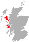
 The approximate divisions of Scotland used in the Scottish Mountaineering Club's, Munro's Tables | |
| Highest point | |
| Elevation | Metres |
| Prominence | no requirement |
| Geography | |
| Location | 282 Munros |
| Parent range | w |
As of June 2019, this is the list of the 282 Munros, recognised by the Scottish Mountaineering Club ("SMC") and The Munro Society.[1] The Munros are listed by "Section" per the Munro's Tables,[2] and in descending order of height within each section. Hills are divided by sub-region, and hills with less than 200 m (656 ft) relative height (or prominence) are indented. The term Real Munro is used for hills with a prominence above 150 m (492 ft), which is the threshold for a Marilyn. For a single table of all 282 Munros, or all 227 Munro Tops, ranked by height and by prominence, see the "List of Munro mountains in Scotland".
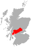
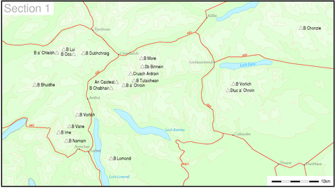
Section one: Firth of Clyde to Strathtay[]
| Height Rank | Prom. Rank | Name | Gaelic Name | Pronunciation | Translate | Munro Since | Parent | Section / Region | County | Height (m) | Prom. (m) | Height (ft) | Prom. (ft) | Topo Map | OS Grid Reference | Classification (§ DoBIH codes) |
|---|---|---|---|---|---|---|---|---|---|---|---|---|---|---|---|---|
| 249 | 44 | Ben Chonzie | Beinn a' Chòinnich | [ˈpeiɲ ə ˈxɔːɲɪç] ( |
mountain of the moss | 1891 | Ben More | 01A: Loch Tay to Perth | Perth and Kinross | 931 | 648 | 3,054 | 2,126 | 51 52 | NN773308 | Ma,M,Sim |
| 165 | 19 | Ben Vorlich | Beinn Mhùrlaig | [peɲ ˈvuːrˠl̪ˠɛkʲ] ( |
hill of the bay | 1891 | Ben More | 01B: Strathyre to Strathallan | Perth and Kinross | 985 | 834 | 3,232 | 2,736 | 57 | NN629189 | Ma,M,Sim |
| 180 | 137 | Stùc a' Chroin | Stùc a' Chroin | [ˈs̪t̪uːxk ə ˈxɾɔɲ] ( |
the peak of the danger | 1891 | Ben Vorlich | 01B: Strathyre to Strathallan | Perth and Kinross/Stirling | 975 | 252 | 3,199 | 827 | 57 | NN617174 | Ma,M,Sim |
| 16 | 4 | Ben More | A' Bheinn Mhòr | [ə ˈveiɲ ˈvoːɾ] ( |
the big mountain | 1891 | Ben Nevis | 01C: Loch Lomond to Strathyre | Stirling | 1174 | 986 | 3,852 | 3,235 | 51 | NN432244 | Ma,M,Sim,CoU,CoA |
| 18 | 120 | Stob Binnein | Stob Binnein | [ˈs̪t̪op ˈpiɲɛɲ] ( |
conical peak | 1891 | Ben More | 01C: Loch Lomond to Strathyre | Stirling | 1165 | 303 | 3,822 | 994 | 51 | NN435228 | Ma,M,Sim |
| 87 | 64 | Cruach Ardrain | Cruach Àrdrain | [ˈkʰɾuəx ˈaːrˠt̪ɾɛɲ] ( |
stack of the high part | 1891 | Ben More | 01C: Loch Lomond to Strathyre | Stirling | 1045.9 | 549 | 3,431 | 1,801 | 51 56 | NN409212 | Ma,M,Sim |
| 222 | 235 | Beinn Tulaichean | Beinn Thulaichean | [ˈpeiɲ ˈhul̪ˠɪçən] ( |
mountain of hillocks | 1891 | Cruach Ardrain | 01C: Loch Lomond to Strathyre | Stirling | 945.8 | 122 | 3,103 | 400 | 56 | NN416196 | Hu,M,Sim |
| 147 | 76 | An Caisteal | An Caisteal | [əŋ ˈkʰaʃtʲəl̪ˠ] ( |
the castle | 1891 | Cruach Ardrain | 01C: Loch Lomond to Strathyre | Stirling | 995.8 | 473 | 3,267 | 1,552 | 50 56 | NN378193 | Ma,M,Sim |

1c. Loch Lomond to Strathyre
- Beinn a' Chroin (941.4 m) Gaelic: Beinn a' Chroin [peɲ ə ˈxɾɔɲ] (
 listen)
 - Ben Lomond (974 m) Gaelic: Beinn Laomainn [peɲ ˈl̪ˠɯːmɪɲ] (listen)
- Beinn Chabhair (932.1 m) Gaelic: Beinn a' Chabhair [ˈpeiɲ ə ˈxavɪɾʲ] (listen)
1d. Inveraray to Crianlarich
- Ben Lui (1130 m) Gaelic: Beinn Laoigh [peɲ ˈl̪ˠɤj] (listen)
- Beinn a' Chleibh (916.3 m) Gaelic: Beinn a' Chlèibh [ˈpeiɲ ə ˈxleːv] (listen)
- Beinn a' Chleibh (916.3 m) Gaelic: Beinn a' Chlèibh [ˈpeiɲ ə ˈxleːv] (
- Ben Oss (1029 m) Gaelic: Beinn Ois [peɲ ˈɔʃ] (listen)
- Beinn Dubhchraig (978 m) Gaelic: Beinn Dubh-chreig [peɲ ˈt̪uxɾʲekʲ] (listen)
- Beinn Dubhchraig (978 m) Gaelic: Beinn Dubh-chreig [peɲ ˈt̪uxɾʲekʲ] (
- Beinn Ìme (1011 m) Gaelic: Beinn Ime [peɲ ˈimə] (listen)
- Beinn Bhuidhe (948.5 m) Gaelic: A' Bheinn Bhuidhe [ə ˈveiɲ ˈvujə] (listen)
- Ben Vorlich (943 m) Gaelic: Beinn Mhùrlaig [peɲ ˈvuːrˠl̪ˠɛkʲ] (listen)
- Beinn Narnain (927 m) Gaelic: Beinn Nàrnain [ˈpe ˈn̪ˠaːrˠnɛɲ]
- Ben Vane (915.76 m) Gaelic: A' Bheinn Mheadhain [ə ˈveiɲ ˈviə.ɛɲ] (listen)
Section two: Loch Rannoch to Loch Tay[]


2a. Loch Rannoch to Glen Lyon
- Schiehallion (1083 m)
- Beinn a' Chreachain (1080.6 m)
- Beinn Dorain (1076 m)
- Càrn Mairg (1042 m)
- Càrn Gorm (1029 m)
- Meall nan Aighean (981 m)
- Meall Garbh (Càrn Mairg Group) (968 m)
- Beinn Achaladair (1038.5 m)
- Beinn an Dothaidh (1004 m)
- Stuchd an Lochain (960 m)
- Beinn Mhanach (953 m)
- Meall Buidhe (932.1 m)
2b. Glen Lyon to Glen Dochart and Loch Tay
- Ben Lawers (1214 m)
- An Stùc (1117.1 m)
- Meall Garbh (Lawers Group) (1123.1 m)
- Beinn Ghlas (1103 m)
- Meall Greigh (1001 m)
- Beinn Heasgarnich (1077.4 m)
- Meall Corranaich (1069 m)
- (925.6 m)
- Creag Mhòr (1047 m)
- Meall nan Tarmachan (1043.5 m)
- Meall Ghaordaidh (1039.8 m)
- Ben Challum (1025 m)
- Meall Glas (959 m)
- Sgiath Chuil (920 m)
Section three: Loch Leven to Connel Bridge and []


3a. Loch Leven to Rannoch Station
- Aonach Eagach - Sgor nam Fiannaidh (967.7 m)
- Meall Dearg (952.2 m)
3b. Loch Linnhe to Loch Etive
- Bidean nam Bian (1149.4 m)
- Stob Coire Sgreamhach (1072 m)
- Beinn a' Bheithir - Sgorr Dhearg (1024 m)
- Sgorr Dhonuill (1001 m)
- Buachaille Etive Mòr - Stob Dearg (1021.4 m)
- Sgor na Bròige (953.4 m)
- Sgùrr na h-Ulaidh (994 m)
- Beinn Fhionnlaidh (959 m)
- Buachaille Etive Beag - Stob Dubh (958 m)
- Stob Coire Raineach (925 m)
- Beinn Sgulaird (937 m)
3c. Glen Etive to
- Ben Cruachan (1127 m)
- (999.2 m)
- Meall a' Bhùiridh (1107.9 m)
- Creise (1099.8 m)
- Stob Ghabhar (1090 m)
- Ben Starav (1078 m)
- Stob Coir' an Albannaich (1044 m)
- Meall nan Eun (928 m)
- (997 m)
- Beinn Eunaich (989 m)
- Beinn a' Chochuill (980 m)
- Beinn nan Aighenan (960 m)
- Stob a' Choire Odhair (945 m)
Section four: Fort William to Loch Ericht[]

4a. Fort William to Loch Treig
- Ben Nevis (1345 m)
- Càrn Mòr Dearg (1220 m)
- Aonach Beag (1234 m)
- Aonach Mòr (1221 m)
- Stob Choire Claurigh (1177 m)
- Stob Coire an Laoigh (1116 m)
- (1094 m)
- Stob Bàn (977 m)
- Stob Coire Easain (1115 m)
- Stob a' Choire Mheadhoin (1105 m)
4b. The Mamores
- Binnein Mòr (1130 m)
- Na Gruagaichean (1054.2 m)
- Binnein Beag (943 m)
- Sgùrr a' Mhàim (1099 m)
- Am Bodach (1031.8 m)
- An Gearanach (981.4 m)
- Stob Coire a' Chàirn (981.4 m)
- Sgùrr Eilde Mòr (1010 m)
- Stob Bàn (999.7 m)
- Mullach nan Coirean (939.3 m)
4c. Loch Treig to Loch Ericht
- Ben Alder (1148 m)
- Beinn Bheòil (1019 m)
- Geal-Chàrn (1132 m)
- Aonach Beag (1115.8 m)
- (1103.2 m)
- (1034 m)
- Beinn a' Chlachair (1087 m)
- Geal Charn (1049 m)
- (924 m)
- Chno Dearg (1046 m)
- (979 m)
- Sgor Gaibhre (955 m)
- Càrn Dearg (941 m)
- Beinn na Lap (935 m)
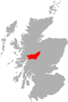
Section five: Loch Ericht to and []
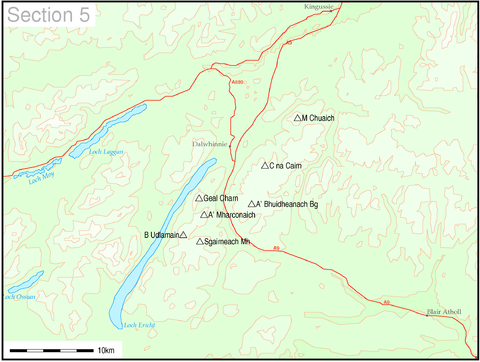

5a. Loch Ericht to
- Beinn Udlamain (1010.2 m)
- Sgairneach Mhòr (991 m)
- (917.1 m)
- A' Mharconaich (973.2 m)
5b. to
- Meall Chuaich (951 m)
- Càrn na Caim (940.8 m)
- A' Bhuidheanach Bheag (936 m)
Section six: to Braemar and Blairgowrie[]
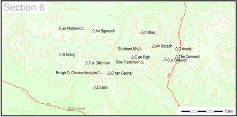

6a. to Glen Tilt
- Beinn Dearg (1008.7 m)
- An Sgarsoch (1006.5 m)
- Càrn an Fhidhleir (994 m)
- Càrn a' Chlamhain (963.5 m)
6b. Pitlochry to Braemar and Blairgowrie
- Beinn a' Ghlò - Càrn nan Gabhar (1121.9 m)
- Bràigh Coire Chruinn-bhalgain (1070 m)
- Glas Tulaichean (1051 m)
- Beinn Iutharn Mhòr (1045 m)
- (1029 m)
- Càrn Liath (976 m)
- Càrn a' Gheòidh (975 m)
- The Cairnwell (933 m)
- Carn Aosda (915.3 m)
Section seven: Braemar to Montrose[]


- Lochnagar (1156 m)
- (1109.9 m)
- Glas Maol (1068 m)
- Cairn of Claise (1064 m)
- (1047 m)
- (1019 m)
- Cairn Bannoch (1012 m)
- Broad Cairn (998 m)
- (988.2 m)
- (958 m)
- (957 m)
- Driesh (947 m)
- Mayar (928 m)
- Mount Keen (939 m)
Section eight: The Cairngorms[]


- Ben Macdui (1309 m)
- Cairn Gorm (1244.8 m)
- Derry Cairngorm (1155 m)
- Braeriach (1296 m)
- Cairn Toul (1291 m)
- Sgor an Lochain Uaine (1258 m)
- The Devil's Point (1004 m)
- Beinn a' Bhùird (1197 m)
- Ben Avon - Leabaidh an Daimh Bhuidhe (1171 m)
- Beinn Mheadhoin (1182.9 m)
- Beinn Bhrotain (1157 m)
- Monadh Mòr (1113 m)
- Sgor Gaoith (1118 m)
- Mullach Clach a' Bhlàir (1019 m)
- Bynack More (1090 m)
- Beinn a' Chaorainn (Cairngorms) (1083 m)
- Beinn Bhreac (931 m)
- Càrn a' Mhàim (1037 m)
Section nine: Spean Bridge to Elgin[]


9a. The Monadh Liath
- Càrn Dearg (945.7 m)
- (929.2 m)
- (926 m)
- (920.3 m)
9b. Loch Lochy to Loch Laggan
- Creag Meagaidh (1128 m)
- Stob Poite Coire Ardair (1054 m)
- Càrn Liath (1006 m)
- Beinn a' Chaorainn (1052 m)
- Beinn Teallach (914.6 m)
Section ten: Glen Shiel to Glenfinnan[]

10a. Glen Shiel to Loch Hourn and
- Gleouraich (1035 m)
- Sgùrr a' Mhaoraich (1027 m)
- Aonach air Chrith (1019.5 m)
- Sgùrr an Doire Leathain (1010 m)
- (1004 m)
- (987 m)
- (980.3 m)
- (946 m)
- Creag nan Damh (917.2 m)
- The Saddle (1011.4 m)
- Spidean Mialach (996 m)
- Beinn Sgritheall (974 m)
- Sgùrr na Sgine (946 m)
10b. Knoydart to Glen Kingie
- Sgùrr na Cìche (1040 m)
- Garbh Chioch Mhòr (1013 m)
- Ladhar Bheinn (1020 m)
- Sgùrr Mòr (1003 m)
- Sgùrr nan Coireachan (956 m)
- Meall Buidhe (946 m)
- Luinne Bheinn (939 m)
- Gairich (919 m)
10c. Loch Arkaig to Glen Moriston
- Sròn a' Choire Ghairbh (937 m)
- Meall na Teanga (916.8 m)
10d. Mallaig to Fort William
- Gaor Bheinn or Gulvain (987 m)
- Sgùrr Thuilm (963 m)
- Sgùrr nan Coireachan (956 m)
Section eleven: Loch Duich to Loch Ness, South of Loch Mullardoch[]
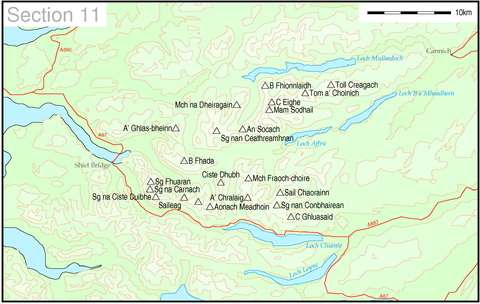

11a. Loch Duich to Cannich
- Càrn Eige (1182.8 m)
- Mam Sodhail (1179.4 m)
- Tom a' Choinich (1112 m)
- Toll Creagach (1054 m)
- Beinn Fhionnlaidh (1004.7 m)
- Sgùrr nan Ceathreamhnan (1151 m)
- (982 m)
- (921 m)
- Sgùrr Fhuaran (1068.7 m)
- Sgùrr na Ciste Duibhe (1027 m)
- Sgùrr na Càrnach (1002 m)
- Sgùrr a' Bhealaich Dheirg (1036 m)
- Aonach Meadhoin (1001 m)
- Sàileag (956 m)
- Beinn Fhada (1032 m)
- Ciste Dhubh (979 m)
- A' Ghlas-bheinn (918 m)
11b. Glen Affric to Glen Moriston
- A' Chràlaig (1120 m)
- Mullach Fraoch-choire (1102 m)
- Sgùrr nan Conbhairean (1109 m)
- (1002 m)
- (957 m)
Section twelve: Kyle of Lochalsh to Inverness, North of Loch Mullardoch[]

12a. Kyle of Lochalsh to Garve
- Sgùrr a' Choire Ghlais (1083 m)
- (1049 m)
- Càrn nan Gobhar (Strathfarrar) (992 m)
- Sgurr a' Chaorachain (1053 m)
- Sgùrr Choinnich (999.2 m)
- Maoile Lunndaidh (1004.9 m)
- (993 m)
- Lurg Mhòr (987 m)
- Bidein a' Choire Sheasgaich (945 m)
- Mòruisg (928 m)
12b. Killilan to Inverness
- Sgùrr na Lapaich (1151 m)
- Càrn nan Gobhar (Mullardoch)(992 m)
- An Riabhachan (1129 m)
- An Socach (1069 m)
Section thirteen: Loch Carron to Loch Maree[]


13a. Loch Torridon to Loch Maree
- Liathach - Spidean a' Choire Leith (1055 m)
- Mullach an Rathain (1023.8 m)
- Beinn Eighe - Ruadh-stac Mòr (1010 m)
- Spidean Coire nan Clach (993 m)
- Beinn Alligin - Sgùrr Mhòr (986 m)
- Tom na Gruagaich (922 m)
13b. Applecross to Achnasheen
- Sgorr Ruadh (960.7 m)
- Maol Chean-dearg (933 m)
- Beinn Liath Mhòr (926 m)
Section fourteen: Loch Maree to Loch Broom and Garve[]


14a. Loch Maree to Loch Broom
- An Teallach - Bidein a' Ghlas Thuill (1062.5 m)
- (1058.6 m)
- Mullach Coire Mhic Fhearchair (1015.2 m)
- (989 m)
- Slioch (981 m)
- A' Mhaighdean (967 m)
- Ruadh Stac Mòr (918.7 m)
- Beinn Tarsuinn (933.8 m)
14b.
- Sgùrr Mòr (1109 m)
- (954 m)
- (949 m)
- Meall a' Chrasgaidh (934 m)
- (923.9 m)
- Sgùrr nan Clach Geala (1093 m)
- Sgùrr nan Each (923 m)
- Sgùrr Breac (999 m)
- A' Chailleach (997 m)
- Fionn Bheinn (933 m)
Section fifteen: Ullapool to the Moray Firth[]


15a. Loch Broom to Strath Oykel
- Beinn Dearg (1084 m)
- Cona' Mheall (978 m)
- (977 m)
- (927 m)
- Am Faochagach (953 m)
- Seana Bhràigh (926 m)
15b. to the Moray Firth
- Ben Wyvis - Glas Leathad Mòr (1046 m)
Section sixteen: The Far North[]


16a. Durness to Loch Shin
- Ben Hope (927 m)
16b. Altnaharra to Dornoch
- Ben Klibreck - Meall nan Con (962.1 m)
16c. Scourie to Lairg
- Ben More Assynt (998 m)
- Conival (987 m)
Section seventeen: Skye and Mull[]
17a. Skye Cuillin
17b. Mull
|
  |
Bibliography[]
- Donald Bennet; Rab Anderson (2006). The Munros: Scottish Mountaineering Club Hillwalkers' Guide. Scottish Mountaineering Club. ISBN 978-0907521945.
- Sir Hugo T. Munro; Derek A. Bearhop (1997). Munro's Tables (Scottish Mountaineering Club District Guides). Scottish Mountaineering Club. ISBN 978-0907521532.
See also[]
- Lists of mountains and hills in the British Isles
- List of mountains of the British Isles by height
- List of Munro and Munro Tops in Scotland
- List of Murdos (mountains)
- List of Corbetts (mountains)
- List of Grahams (mountains)
- List of Donald mountains in Scotland
References[]
- ^ "Hill Lists: Munros". Scottish Mountaineering Club.
The current list contains 282 peaks. The SMC maintains the list of Munros. In recent times the list has only been altered to reflect updates to nationally recognised topographic data (i.e. data recognised and adopted by the Ordnance Survey). We record all such changes as hill news.
- ^ Sir Hugo T. Munro; Derek A. Bearhop (1997). Munro's Tables (Scottish Mountaineering Club District Guides). Scottish Mountaineering Club. ISBN 978-0907521532.
External links[]
- Scottish Mountaineering Club - The SMC maintain the lists of Munros, Munro Tops, Furths, Corbetts and Donalds. They also keep a record of Completionists.
- Walkhighlands guide to the Munros – Features podcasts giving the correct pronunciation and place-name meanings, a 3D visualisation of every route, gradient profiles and route downloads for GPS devices.
- MunroMagic.com – Munro, Corbett and Graham descriptions, pictures, location maps, walking routes and weather reports.
- Hill Bagging - the online version of the Database of British and Irish Hills - Survey reports, the change control database and the GPS database are on Hill Bagging.
- The Munros and Tops 1891–1997 – Spreadsheet showing changes in successive editions of Munros Tables.
- Ordnance Survey Munro Blog - OS is Britain's mapping agency. They make the most up-to-date and accurate maps of the United Kingdom. They have also produced a blog on the Munros.
- Harold Street Munros Lists of GPS waypoints + Grid References for walking in UK mountains and hills in various GPS file formats.
- ScottishHills.com – Hillwalking forum with Munro, Corbett, Graham and Donald, Sub 200's log, maps and trip reports.
| hide Mountains and hills of Great Britain and Ireland | ||
|---|---|---|
| British Isles |
|  |
| Scotland |
| |
| Outside Scotland |
| |
| England |
| |
| Ireland |
| |
| County tops |
| |
- Munros
- Peak bagging
- Tourist attractions in Scotland