List of Pennsylvania state historical markers in Huntingdon County

Location of Huntingdon County in Pennsylvania
This is a list of the Pennsylvania state historical markers in Huntingdon County.
This is intended to be a complete list of the official state historical markers placed in Huntingdon County, Pennsylvania by the Pennsylvania Historical and Museum Commission (PHMC). The locations of the historical markers, as well as the latitude and longitude coordinates as provided by the PHMC's database, are included below when available. There are 23 historical markers located in Huntingdon County.[1]
Historical markers[]
| Marker title | Image | Date dedicated | Location | Marker type | Topics |
|---|---|---|---|---|---|
| Admiral Wm. Sims | 
|
April 23, 1995 | Pa. 994 in Rockville, W of U.S. 522 40°14′18″N 77°54′06″W / 40.2382°N 77.90167°W |
Roadside | Military, Military Post-Civil War |

|
April 28, 1947 | US 522, at SE end of Orbisonia |
Roadside | Business & Industry, Coal, Furnaces, Iron | |
|
|
April 30, 1947 | Pa. 45, 1.6 miles NE of Spruce Creek 40°37′38″N 78°06′51″W / 40.6272°N 78.11406°W |
Roadside | Business & Industry, Coal, Iron | |
| David R. Porter | 
|
October 15, 1955 | 3rd & Penn Sts., Huntingdon 40°29′02″N 78°00′32″W / 40.48378°N 78.00891°W |
City | Government & Politics, Government & Politics 19th Century, Governors, Professions & Vocations |
| Fort Roberdeau | 
|
April 30, 1947 | Pa. 453 & Truck Pa. 45 just S of Union Furnace (MISSING) 40°36′35″N 78°10′08″W / 40.60975°N 78.16875°W |
Roadside | American Revolution, Forts, Military |
| Fort Shirley |
|
April 25, 1947 | U.S. 522 at N end Shirleysburg 40°18′06″N 77°52′27″W / 40.30174°N 77.87404°W |
Roadside | Forts, French & Indian War, Military |
|
|
May 1, 1926 | US 522, Shirleysburg 40°18′05″N 77°52′28″W / 40.30131°N 77.87431°W |
Plaque | Forts, French & Indian War, Military | |
|
|
October 15, 1955 | Penn St., Huntingdon 40°28′54″N 78°00′15″W / 40.48162°N 78.00411°W |
Roadside | American Revolution, Forts, Military, Native American | |
| Frankstown Path | 
|
March 16, 1949 | US 22 at Water Street, PA (town name) 40°34′15″N 78°08′03″W / 40.57096°N 78.13425°W |
Roadside | Paths & Trails, Transportation |
| Greenwood Furnace | 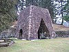
|
April 30, 1947 | Pa. 305 at Greenwood Furnace State Park 40°38′57″N 77°45′25″W / 40.64903°N 77.75705°W |
Roadside | Business & Industry, Furnaces, Iron |
| Hart's Log |
|
March 16, 1946 | PA 305 at US22 junction, just S of Alexandria 40°33′27″N 78°05′57″W / 40.55737°N 78.0993°W |
Roadside | Early Settlement, Paths & Trails, Professions & Vocations, Transportation |
| Huntingdon County |
|
September 20, 1982 | County Courthouse, Penn St., Huntingdon 40°29′01″N 78°00′29″W / 40.48364°N 78.00813°W |
City | Government & Politics, Government & Politics 18th Century |
| Jack's Narrows |
|
June 6, 1946 | U.S. 22, 8.5 miles SE of Huntingdo (Missing) |
Roadside | Environment |
|
|
April 29, 1947 | U.S. 522, 1 mile S of Orbisonia |
Roadside | Business & Industry, Coal, Iron | |
|
|
April 29, 1947 | U.S. 22 just E of Water Street 40°34′15″N 78°08′02″W / 40.57088°N 78.13396°W |
Roadside | Business & Industry, Coal, Iron | |
| Martin G. Brumbaugh | 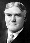
|
July 1, 1949 | Pa. 26, 1.3 miles NE of Marklesburg 40°23′49″N 78°08′56″W / 40.39705°N 78.1488°W |
Roadside | Education, Government & Politics, Government & Politics 20th Century, Governors |
| Martin G. Brumbaugh |
|
July 23, 1948 | US 22 & PA 26, W of Huntingdon 40°29′31″N 78°02′24″W / 40.49208°N 78.04007°W |
Roadside | Education, Governors, Professions & Vocations |
|
|
n/a | Junction Pa. 305 & Pa. 545 at McAlevy's Fort (Missing) |
Roadside | American Revolution, Military | |
|
|
October 15, 1955 | 4th & Penn. Huntingdon 40°29′04″N 78°00′38″W / 40.48447°N 78.01069°W |
City | Buildings, Mansions & Manors | |
|
|
April 30, 1947 | Spruce Creek Rd. (PA 45) at Pennsylvania Furnace Rd., PA Furnace 40°42′06″N 77°59′58″W / 40.70172°N 77.99935°W |
Roadside | Business & Industry, Coal, Furnaces, Iron | |
| Rural Electrification |
|
July 5, 1992 | 10700 Fairgrounds Rd., Huntingdon 40°30′34″N 77°58′44″W / 40.5094°N 77.97878°W |
Roadside | Business & Industry, Electricity |
|
|
April 28, 1947 | Croghan Pike (US 522) W of Shade Gap 40°11′19″N 77°52′32″W / 40.18869°N 77.87561°W |
Roadside | Paths & Trails, Transportation | |
|
|
April 21, 1949 | Spruce Creek Rd. (PA 45) at church, just NE of Graysville 40°41′27″N 78°17′17″W / 40.69087°N 78.288°W |
Roadside | Religion |

See also[]
- List of Pennsylvania state historical markers
- National Register of Historic Places listings in Huntingdon County, Pennsylvania
References[]
- ^ "PHMC Historical Markers Search" (Searchable database). Pennsylvania Historical and Museum Commission. Commonwealth of Pennsylvania. Retrieved 2010-07-19.
External links[]
Municipalities and communities of Huntingdon County, Pennsylvania, United States | ||
|---|---|---|
| Boroughs |  | |
| Townships | ||
| CDPs | ||
| Unincorporated communities | ||
| Ghost town | ||
| Footnotes | ‡This populated place also has portions in an adjacent county or counties | |
| ||
Harrisburg (capital) | ||
| Topics |
| |
| Society | ||
| Metro areas |
| |
| Largest cities |
| |
| Largest municipalities |
| |
| Regions |
| |
| Counties |
| |

Pennsylvania Historical and Museum Commission | ||
|---|---|---|
| Museums and Archives |
|  |
Categories:
- Huntingdon County, Pennsylvania
- Pennsylvania state historical markers
- Tourist attractions in Huntingdon County, Pennsylvania