List of World Heritage Sites in Kazakhstan
The United Nations Educational, Scientific and Cultural Organization (UNESCO) designates World Heritage Sites of outstanding universal value to cultural or natural heritage which have been nominated by countries which are signatories to the UNESCO World Heritage Convention, established in 1972.[1] Cultural heritage consists of monuments (such as architectural works, monumental sculptures, or inscriptions), groups of buildings, and sites (including archaeological sites). Natural features (consisting of physical and biological formations), geological and physiographical formations (including habitats of threatened species of animals and plants), and natural sites which are important from the point of view of science, conservation or natural beauty, are defined as natural heritage.[2] Kazakhstan accepted the convention on 29 April 1994.[3]
As of 2021, there are five World Heritage Sites listed in Kazakhstan, with a further 14 on the tentative list.[3] The first site inscribed to the list was the Mausoleum of Khoja Ahmed Yasawi, at the 27th Session of the World Heritage Committee, held in Paris in 2003.[4] The most recent sites listed were two transnational sites: Silk Roads: the Routes Network of Chang'an-Tianshan Corridor, listed in 2014, is shared with China and Kyrgyzstan, while Western Tien-Shan, shared with Kyrgyzstan and Uzbekistan, was listed in 2016. Three sites are cultural while Saryarka – Steppe and Lakes of Northern Kazakhstan and Tien-Shan are natural.[3]
World Heritage Sites[]
UNESCO lists sites under ten criteria; each entry must meet at least one of the criteria. Criteria i through vi are cultural, whereas vii through x are natural.[5]
| Site | Image | Location | Year listed | UNESCO data | Description |
|---|---|---|---|---|---|
| Mausoleum of Khoja Ahmed Yasawi | 
|
Turkestan | 2003 | 1103; i, iii, iv (cultural) | The mausoleum, dedicated to the 12th century Sufi mystic Ahmad Yasawi, was built between 1389 and 1405 during the rule of Timur. Even if the mausoleum remains partially unfinished, it is one of the largest and best-preserved Timurid buildings. It was also a prototype for later Timurid buildings, especially in the capital Samarkand.[6] |
| Petroglyphs within the Archaeological Landscape of Tamgaly | 
|
Almaty Region | 2004 | 1145; iii (cultural) | Petroglyphs in the Tanbaly Gorge in Chu-Ili mountains depict humans, animals, and religious figures. They date from the second half of the second millennium BC to the beginning of the 20th century and provide insight into the life of pastoral communities that lived in the region. A number of tombs, kurgans, and enclosures from Bronze and Iron Age have also been found in the area.[7] |
| Saryarka – Steppe and Lakes of Northern Kazakhstan | 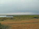
|
Almaty Region | 2008 | 1102; ix, x (natural) | Saryarka comprises two areas, Naurzum Nature Reserve and Korgalzhyn Nature Reserve (pictured), that protect the largely undisturbed Central Asian steppe, lakes, and wetlands. These habitats are an important stopover for migratory birds and provide sanctuaries for a large number of threatened species, including Siberian white cranes, Dalmatian pelicans, Pallas's fish eagles and Saiga antelopes.[8] |
| Silk Roads: the Routes Network of Chang'an-Tianshan Corridor* | 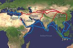
|
several sites | 2014 | 1442; ii, iii, v, vi (cultural) | Silk Road is an ancient network of trade routes that started forming in the 2nd century BCE and remained active until the 16th century. The roads connected societies of Asia, the Subcontinent, Central Asia, Western Asia, and the Near East. In addition to exchange of goods, they also contributed to the spread of technologies, ideologies, and religions, including Buddhism, Nestorian Christianity, Manichaeism, Zoroastrianism and early Islam. Several towns and supporting infrastructure have been constructed along the routes. This World Heritage site covers the corridors from Chang’an/Luoyang, the Han and Tang capitals of China, to the Zhetysu region of Central Asia, and is shared with China and Kyrgyzstan.[9] |
| Western Tien-Shan* | 
|
several sites | 2016 | 1490; x (natural) | The property, shared with Kyrgyzstan and Uzbekistan, covers the western part of the Tian Shan mountain range. It is rich in biodiversity and a number of cultivated fruit crops originate from the area. Mountain peaks reach above 4,500 metres (14,800 ft). Aksu Canyon is pictured.[10] |
Tentative list[]
In addition to sites inscribed on the World Heritage List, member states can maintain a list of tentative sites that they may consider for nomination. Nominations for the World Heritage List are only accepted if the site was previously listed on the tentative list.[11] As of 2021, Kazakhstan lists 14 properties on its tentative list.[3]
| Site | Image | Location | Year listed | UNESCO criteria | Description |
|---|---|---|---|---|---|
| Turkic Sanctuary of Merke | – | Jambyl Region | 1998 | (mixed) | The burial and ritual complex represents different stages of history of Turkic peoples, from nomadic tribes to First Turkic Khaganate. It is located at an elevation of 3,000 metres (9,800 ft), and has been well preserved due to its remote location. More than 170 monuments, some containing steles, have been found spread over the mountain plateau.[12] |
| Megalithic mausolea of the Begazy-Dandybai culture | – | Central Kazakhstan | 1998 | ii, iii, iv (cultural) | The mausolea, located in mountain valleys in central Kaazhkstan, were built by the Begazy-Dandybai culture between the 12th and 8th centuries BCE. Eighteen mausolea have so far been uncovered, as well as ordinary burial sites and remains of settlements. The common feature of the mausolea is a central room surrounded by two or three perimeter walls made of stacked stone or large vertical stone slabs. The central rooms house sarcophagi and altars.[13] |
| Barrows with stone ranges of the Tasmola culture | – | Central Kazakhstan | 1998 | (mixed) | The barrows (or tumuli) were built in the Saka period (7th to 3rd century BCE) by the Tasmola culture. The sites are characterized by stone complexes with up to four stone barrows, menhirs (single or in groups), and two curved ranges that can each stretch up to 200 metres (660 ft). The layout of these complexes has been associated with positions of Sun during the solstice and equinoxes.[14] |
| Petroglyphs of Eshkiolmes | – | Almaty region | 1998 | (mixed) | The petroglyphs in the Eshkiolmes mountain range date from the early Iron Age to the Middle Ages. They depict the life of nomadic societies and are rich in details, showing clothes, arms, and tools.[15] |
| Petroglyphs of Arpa-Uzen | – | Karatau Mountains | 1998 | ii, iii, iv (cultural) | The petroglyphs in the Karatau Mountains range date from the late Bronze Age to the early Iron Age. They depict aspects of life of steppe nomads, including scenes with horses and camels. Some of the earlier petroglyphs were later overdrawn by the Saka people, forming a palimpsest.[16] |
| Paleolithic sites and geomorphology of Karatau mountain range | – | Karatau Mountains | 1998 | (mixed) | More than 300 Paleolithic sites have been so far discovered in the Karatau Mountains, with only part of them excavated. Flint tools from the Lower Paleolithic, 1 million to 500.000 years ago, have been found, as well as Mousterian stone tools. After a period of depopulation, Neolithic cultures appeared in the area around 4500 BCE.[17] |
| Archaeological sites of Otrar oasis | 
|
Turkistan Region | 1998 | iii, iv (cultural) | During the 1st millennium CE, several towns prospered in the Otrar oasis, the largest of them was Otrar. In the first century CE, it was a part of the Kangju empire, in the 8th century, it was the capital of the Kangly people. Early Islamic philosopher Al-Farabi was born in Otrar in 870 and Timur died there in 1405. Towns in the oasis declined in the 15th century. Archeological excavations uncovered town plans and irrigation channels.[18] |
| Cultural landscape of Ulytau | 
|
Ulytau District | 1998 | (mixed) | The area of Ulytau has been colonized around 4500 BCE by the Neolithic cultures. In the Middle Ages, it became an important migration corridor for nomadic Turkic tribes. Three mausolea of the Golden Horde khans are preserved (the one of Jochi pictured). The area is also the site of the secret burial place of Genghis Khan. From the natural perspective, the region is important for migratory birds, including black storks and flamingos.[19] |
| Northern Tyan-Shan (Ile-Alatau State National Park) | 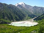
|
Almaty Region | 2002 | x (natural) | The national park in the northern Tian Shan mountains (the Trans-Ili Alatau range) features woodlands, alpine meadows, over 300 glaciers, and mountain lakes (Big Almaty Lake pictured). The park is home to snow leopards, Turkestan lynx, Tian Shan brown bears, beech marten, Siberian ibexes, bearded vultures, golden eagles, as well as numerous butterfly species.[20] |
| State National Natural Park "Altyn-Emel" | 
|
Almaty Region | 2002 | vii, viii, ix (natural) | The area in the Dzungarian Alatau mountain range consists mostly of arid and rocky terrain. It is home to argali, Mongolian wild ass, and goitered gazelle, as well as several species of fish and amphibians. The climate is harsh continental with cold winters and hot summers.[21] |
| Aksu-Zhabagly Nature Reserve | 
|
Turkistan Region | 2002 | vii, ix (natural) | The nature reserve is located in the western Tian Shan mountains. The snow line in the mountains is at 3,300 metres (10,800 ft), and there are several glaciers. The weather is harsh continental, with rainfall predominantly in winter and spring. The area is home to numerous plant species.[22] |
| Silk Road |
|
several sites | 2012 | ii, iii, iv, v, vi (cultural) | This nomination comprises four sections of Silk Road in Kazakhstan: Semirechye, Syr Darya, Saryarka, and Mangyshlak (Uralo-Prikaspiyskiy). The roads connected societies of Asia, the Subcontinent, Central Asia, Western Asia, and the Near East. In addition to exchange of goods, they also contributed to the spread of technologies, ideologies, and religions. Several towns and supporting infrastructure have been constructed along the routes. [23] |
| Petroglyph Site of Sauyskandyk (XVIII BC – III AD) | – | Karatau Mountains | 2016 | ii, iii, iv (cultural) | Petroglyphs at Sauyskandyk, in the Karatau Mountains, date to different historic periods, from the 2nd millennium BCE to the early 20th century. They document the historical evolution of esthetic norms of nomadic societies. The cultural landscape also includes burial and ceremonial sites and traditional Kazakh houses from the late 19th and early 20th century.[24] |
| Cold winter deserts of Turan (Kazakhstan)* | 
|
Kyzylorda Region, Almaty Region | 2021 | ix, x (natural) | This is a transnational nomination, together with Turkmenistan and Uzbekistan, that represent the ecosystems of Central Asian deserts, with continental climate. The deserts are home to numerous plant species, as well as saiga antelope and goitered gazelle. Two deserts are nominated in Kazakhstan, Barsa-Kelmes Nature Reserve and Altyn-Emel National Park (pictured).[25] |
References[]
- ^ "The World Heritage Convention". UNESCO World Heritage Centre. Archived from the original on 27 August 2016. Retrieved 21 September 2010.
- ^ "Convention Concerning the Protection of the World Cultural and Natural Heritage". UNESCO World Heritage Centre. Archived from the original on 1 February 2021. Retrieved 3 February 2021.
- ^ a b c d "Kazakhstan". UNESCO World Heritage Centre. Archived from the original on 30 May 2016. Retrieved 8 August 2021.
- ^ "Report of the 27th Session of the Committee". UNESCO World Heritage Centre. Archived from the original on 2 August 2009. Retrieved 8 August 2016.
- ^ "UNESCO World Heritage Centre – The Criteria for Selection". UNESCO World Heritage Centre. Archived from the original on 12 June 2016. Retrieved 17 August 2018.
- ^ "Mausoleum of Khoja Ahmed Yasawi". UNESCO World Heritage Centre. Archived from the original on 16 October 2021. Retrieved 16 October 2021.
- ^ "Petroglyphs of the Archaeological Landscape of Tanbaly". UNESCO World Heritage Centre. Archived from the original on 16 October 2021. Retrieved 16 October 2021.
- ^ "Saryarka – Steppe and Lakes of Northern Kazakhstan". UNESCO World Heritage Centre. Archived from the original on 15 October 2021. Retrieved 16 October 2021.
- ^ "Silk Roads: the Routes Network of Chang'an-Tianshan Corridor". UNESCO World Heritage Centre. Archived from the original on 13 February 2021. Retrieved 16 October 2021.
- ^ "Western Tien-Shan". UNESCO World Heritage Centre. Archived from the original on 20 October 2021. Retrieved 16 October 2021.
- ^ "Tentative Lists". UNESCO. Archived from the original on 1 April 2016. Retrieved 7 October 2010.
- ^ "Turkic sanctuary of Merke". UNESCO World Heritage Centre. Archived from the original on 12 May 2021. Retrieved 18 October 2021.
- ^ "Megalithic mausolea of the Begazy-Dandybai culture". UNESCO World Heritage Centre. Archived from the original on 20 October 2021. Retrieved 18 October 2021.
- ^ "Barrows with stone ranges of the Tasmola culture". UNESCO World Heritage Centre. Archived from the original on 12 May 2021. Retrieved 18 October 2021.
- ^ "Petroglyphs of Eshkiolmes". UNESCO World Heritage Centre. Archived from the original on 20 October 2021. Retrieved 18 October 2021.
- ^ "Petroglyphs of Arpa-Uzen". UNESCO World Heritage Centre. Archived from the original on 20 October 2021. Retrieved 18 October 2021.
- ^ "Paleolithic sites and geomorphology of Karatau mountain range". UNESCO World Heritage Centre. Archived from the original on 12 May 2021. Retrieved 18 October 2021.
- ^ "Paleolithic sites and geomorphology of Karatau mountain range". UNESCO World Heritage Centre. Archived from the original on 12 May 2021. Retrieved 18 October 2021.
- ^ "Cultural landscape of Ulytau". UNESCO World Heritage Centre. Archived from the original on 20 October 2021. Retrieved 18 October 2021.
- ^ "Northern Tyan-Shan (Ile-Alatau State National Park)". UNESCO World Heritage Centre. Archived from the original on 23 October 2021. Retrieved 18 October 2021.
- ^ "State National Natural Park "Altyn-Emel"". UNESCO World Heritage Centre. Archived from the original on 22 June 2020. Retrieved 18 October 2021.
- ^ "Aksu-Zhabagly state natural reserve". UNESCO World Heritage Centre. Archived from the original on 19 October 2021. Retrieved 18 October 2021.
- ^ "Silk Road". UNESCO World Heritage Centre. Archived from the original on 12 May 2021. Retrieved 18 October 2021.
- ^ "Petroglyph Site of Sauyskandyk (XVIII BC – III AD)". UNESCO World Heritage Centre. Archived from the original on 30 June 2021. Retrieved 18 October 2021.
- ^ "Cold winter deserts of Turan (Kazakhstan)". UNESCO World Heritage Centre. Retrieved 16 October 2021.
Lists of World Heritage Sites in Asia | ||
|---|---|---|
| Northern and Central Asia | ||
| Western Asia (including Arab States) | ||
| Eastern Asia |
| |
| Southern Asia | ||
| Southeast Asia | ||
- Kazakhstan geography-related lists
- Lists of World Heritage Sites
- World Heritage Sites in Kazakhstan
- Lists of tourist attractions in Kazakhstan