| Courthouse |
Photo |
County |
Location |
Built |
Notes
|
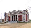
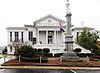
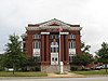
| Abbeville County Courthouse |
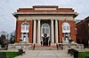 |
Abbeville |
Abbeville
 34°10′40″N 82°22′42″W / 34.17778°N 82.37833°W / 34.17778; -82.37833 (Abbeville County) 34°10′40″N 82°22′42″W / 34.17778°N 82.37833°W / 34.17778; -82.37833 (Abbeville County) |
1908 |
Listed on the National Register of Historic Places
|
|
 |
Aiken |
Aiken
33°33′30″N 81°43′13″W / 33.55833°N 81.72028°W / 33.55833; -81.72028 (Aiken County) |
|
|
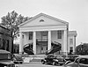
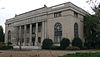
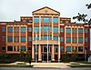
| Allendale County Courthouse |
|
Allendale |
Allendale
33°0′47″N 81°18′21″W / 33.01306°N 81.30583°W / 33.01306; -81.30583 (Allendale County) |
1922 |
Listed on the National Register of Historic Places
|
|
 |
Anderson |
Anderson
34°30′12″N 82°39′0″W / 34.50333°N 82.65000°W / 34.50333; -82.65000 (Anderson County) |
1898 |
Part of the Anderson Downtown Historic District (NRHP)
|
|
|
Bamberg |
Bamberg
33°17′53″N 81°2′2″W / 33.29806°N 81.03389°W / 33.29806; -81.03389 (Bamberg County) |
|
|
|
 |
Barnwell |
Barnwell
33°14′39″N 81°21′55″W / 33.24417°N 81.36528°W / 33.24417; -81.36528 (Barnwell County) |
|
|
|
|
Beaufort |
Beaufort
32°26′17″N 80°41′13″W / 32.43806°N 80.68694°W / 32.43806; -80.68694 (Beaufort County) |
1936 |
Part of the Beaufort Historic District (NRHP)
|
|
|
Berkeley |
Moncks Corner
33°12′2″N 80°1′5″W / 33.20056°N 80.01806°W / 33.20056; -80.01806 (Berkeley County) |
|
|
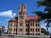
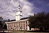
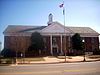
| Calhoun County Courthouse |
 |
Calhoun |
St. Matthews
33°39′49″N 80°46′44″W / 33.66361°N 80.77889°W / 33.66361; -80.77889 (Calhoun County) |
1913 |
Listed on the National Register of Historic Places
|
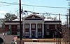
| Charleston County Courthouse |
 |
Charleston |
Charleston
32°46′36″N 79°55′53″W / 32.77667°N 79.93139°W / 32.77667; -79.93139 (Charleston County) |
1753 |
Part of the Charleston Old and Historic District (NRHP)
|
|
|
Cherokee |
Gaffney
35°4′23″N 81°38′52″W / 35.07306°N 81.64778°W / 35.07306; -81.64778 (Cherokee County) |
|
|
|
 |
Chester |
Chester
34°42′22″N 81°12′48″W / 34.70611°N 81.21333°W / 34.70611; -81.21333 (Chester County) |
c.1852 |
Part of the Chester Historic District (NRHP)
|
|
|
Chesterfield |
Chesterfield
34°44′10″N 80°5′7″W / 34.73611°N 80.08528°W / 34.73611; -80.08528 (Chesterfield County) |
1884 |
Part of the East Main Street Historic District (NRHP)
|
|
|
Clarendon |
Manning
33°41′40″N 80°12′41″W / 33.69444°N 80.21139°W / 33.69444; -80.21139 (Clarendon County) |
|
|
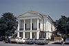
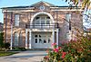
| Colleton County Courthouse |
 |
Colleton |
Walterboro
32°54′9″N 80°40′0″W / 32.90250°N 80.66667°W / 32.90250; -80.66667 (Colleton County) |
1820 |
Listed on the National Register of Historic Places
|
|
|
Darlington |
Darlington
34°18′12″N 79°52′16″W / 34.30333°N 79.87111°W / 34.30333; -79.87111 (Darlington County) |
|
|
| Dillon County Courthouse |
 |
Dillon |
Dillon
34°25′6″N 79°22′32″W / 34.41833°N 79.37556°W / 34.41833; -79.37556 (Dillon County) |
1911 |
Listed on the National Register of Historic Places
|
|
|
Dorchester |
St. George
33°11′6″N 80°34′39″W / 33.18500°N 80.57750°W / 33.18500; -80.57750 (Dorchester County) |
|
|
|
|
Edgefield |
Edgefield
33°47′23″N 81°55′49″W / 33.78972°N 81.93028°W / 33.78972; -81.93028 (Edgefield County) |
1839 |
Part of the Edgefield Historic District (NRHP)
|
|
 |
Fairfield |
Winnsboro
34°22′49″N 81°5′13″W / 34.38028°N 81.08694°W / 34.38028; -81.08694 (Fairfield County) |
1823 |
Part of the Winnsboro Historic District (NRHP)
|
|
|
Florence |
Florence
34°11′55″N 79°46′4″W / 34.19861°N 79.76778°W / 34.19861; -79.76778 (Florence County) |
|
|
|
|
Georgetown |
Georgetown
33°22′0″N 79°16′54″W / 33.36667°N 79.28167°W / 33.36667; -79.28167 (Georgetown County) |
1824 |
Part of the Georgetown Historic District (NRHP)
|
| Greenville County Courthouse |
 |
Greenville |
Greenville
34°50′55″N 82°24′1″W / 34.84861°N 82.40028°W / 34.84861; -82.40028 (Greenville County) |
1916 |
Listed on the National Register of Historic Places
|
|
|
Greenwood |
Greenwood
34°11′17″N 82°9′45″W / 34.18806°N 82.16250°W / 34.18806; -82.16250 (Greenwood County) |
|
|
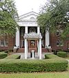
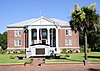
| Hampton County Courthouse |
 |
Hampton |
Hampton
32°51′58″N 81°6′33″W / 32.86611°N 81.10917°W / 32.86611; -81.10917 (Hampton County) |
1878 |
Listed on the National Register of Historic Places
|
|
|
Horry |
Conway
33°50′6″N 79°2′46″W / 33.83500°N 79.04611°W / 33.83500; -79.04611 (Horry County) |
1825 |
Part of the Conway Downtown Historic District (NRHP)
|
| Jasper County Courthouse |
 |
Jasper |
Ridgeland
32°29′3″N 80°59′7″W / 32.48417°N 80.98528°W / 32.48417; -80.98528 (Jasper County) |
1915 |
Listed on the National Register of Historic Places
|
|
|
Kershaw |
Camden
34°14′52″N 80°36′28″W / 34.24778°N 80.60778°W / 34.24778; -80.60778 (Kershaw County) |
|
|
| Lancaster County Courthouse |
 |
Lancaster |
Lancaster
34°43′12″N 80°46′16″W / 34.72000°N 80.77111°W / 34.72000; -80.77111 (Lancaster County) |
1828 |
Listed on the National Register of Historic Places
|
| Laurens County Courthouse |
 |
Laurens |
Laurens
34°29′58″N 82°0′52″W / 34.49944°N 82.01444°W / 34.49944; -82.01444 (Laurens County) |
1838 |
Listed on the National Register of Historic Places
|
| Lee County Courthouse |
 |
Lee |
Bishopville
34°13′1″N 80°14′58″W / 34.21694°N 80.24944°W / 34.21694; -80.24944 (Lee County) |
1908 |
Listed on the National Register of Historic Places
|
| Lexington County Courthouse |
|
Lexington |
Lexington
33°58′49″N 81°14′7″W / 33.98028°N 81.23528°W / 33.98028; -81.23528 (Lexington County) |
|
|
|
|
Marion |
Marion
34°10′43″N 79°24′2″W / 34.17861°N 79.40056°W / 34.17861; -79.40056 (Marion County) |
1853 |
Part of the Marion Historic District (NRHP)
|
|
 |
Marlboro |
Bennettsville
34°37′1″N 79°41′5″W / 34.61694°N 79.68472°W / 34.61694; -79.68472 (Marlboro County) |
1885 |
Part of the Bennettsville Historic District (NRHP)
|
| McCormick County Courthouse |
 |
McCormick |
McCormick
33°54′38″N 82°17′41″W / 33.91056°N 82.29472°W / 33.91056; -82.29472 (McCormick County) |
1923 |
Listed on the National Register of Historic Places
|
|
 |
Newberry |
Newberry
34°16′32″N 81°37′8″W / 34.27556°N 81.61889°W / 34.27556; -81.61889 (Newberry County) |
1908 |
Part of the Newberry Historic District (NRHP)
|
|
 |
Oconee |
Walhalla
34°45′54″N 83°4′5″W / 34.76500°N 83.06806°W / 34.76500; -83.06806 (Oconee County) |
2003 |
|
|
|
Orangeburg |
Orangeburg
33°29′31″N 80°51′46″W / 33.49194°N 80.86278°W / 33.49194; -80.86278 (Orangeburg County) |
|
|
|
 |
Pickens |
Pickens
34°53′0″N 82°42′25″W / 34.88333°N 82.70694°W / 34.88333; -82.70694 (Pickens County) |
|
|
|
|
Richland |
Columbia
34°0′29″N 81°2′15″W / 34.00806°N 81.03750°W / 34.00806; -81.03750 (Richland County) |
|
|
|
|
Saluda |
Saluda
34°0′4″N 81°46′17″W / 34.00111°N 81.77139°W / 34.00111; -81.77139 (Saluda County) |
|
|
|
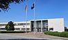 |
Spartanburg |
Spartanburg
34°57′6″N 81°56′8″W / 34.95167°N 81.93556°W / 34.95167; -81.93556 (Spartanburg County) |
1958 |
|
| Sumter County Courthouse |
 |
Sumter |
Sumter
33°55′21″N 80°20′26″W / 33.92250°N 80.34056°W / 33.92250; -80.34056 (Sumter County) |
1907 |
Listed on the National Register of Historic Places
|
|
|
Union |
Union
34°42′55″N 81°37′32″W / 34.71528°N 81.62556°W / 34.71528; -81.62556 (Union County) |
1913 |
Part of the Union Downtown Historic District (NRHP)
|
|
 |
Williamsburg |
Kingstree
33°39′48″N 79°49′51″W / 33.66333°N 79.83083°W / 33.66333; -79.83083 (Williamsburg County) |
1823 |
Part of the Kingstree Historic District (NRHP)
|
|
 |
York |
York
34°59′39″N 81°14′33″W / 34.99417°N 81.24250°W / 34.99417; -81.24250 (York County) |
1914 |
Listed on the National Register of Historic Places
|


