Metropolitan Borough of Bolton
Borough of Bolton | |
|---|---|
 Bolton Town Hall, the seat of Bolton's borough council | |
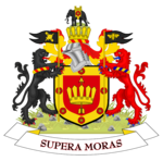 Coat of Arms of the Metropolitan Borough Council | |
| Motto(s): "Supera Moras" (Latin: "Overcome delays") | |
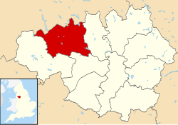 Bolton shown within Greater Manchester | |
| Coordinates: 53°34′53″N 2°25′47″W / 53.58139°N 2.42972°W | |
| Sovereign state | United Kingdom |
| Constituent country | England |
| Region | North West England |
| Ceremonial county | Greater Manchester |
| Admin HQ | Bolton Town Hall |
| Historic county | Salford Hundred, Lancashire |
| Founded | 1 April 1974 |
| Government | |
| • Type | Metropolitan borough |
| • Governing body | Bolton Metropolitan Borough Council |
| • Mayor: | Cllr. Linda Thomas (L) |
| • Leadership: | Leader & Cabinet |
| • Leader: | Martyn Cox (C) |
| • MPs: | Mark Logan (C) Yasmin Qureshi (L) Chris Green (C) |
| Area | |
| • Total | 53.98 sq mi (139.80 km2) |
| Population (mid-2019 est.) | |
| • Total | 287,550 (Ranked 48th) |
| • Density | 4,860/sq mi (1,877/km2) |
| Time zone | UTC+0 (Greenwich Mean Time) |
| Postcode areas | |
| Area code(s) | 01204, 01942, 0161 |
| ISO 3166-2 | GB-BOL |
| ONS code | 00BL (ONS) E08000001 (GSS) |
| OS grid reference | SD715095 |
| NUTS 3 | UKD32 |
| Website | http://www.bolton.gov.uk |

The Metropolitan Borough of Bolton /ˈboʊltən/ (![]() listen) is a metropolitan borough of Greater Manchester, England, named after its largest town, Bolton, but covering a far larger area which includes Blackrod, Farnworth, Horwich, Kearsley,
Westhoughton, and part of the West Pennine Moors. It has a population of 276,800.
listen) is a metropolitan borough of Greater Manchester, England, named after its largest town, Bolton, but covering a far larger area which includes Blackrod, Farnworth, Horwich, Kearsley,
Westhoughton, and part of the West Pennine Moors. It has a population of 276,800.
The boundaries were set by the Local Government Act 1972, and cover eight former local government districts; seven Urban Districts from the administrative county of Lancashire, and the County Borough of Bolton. The metropolitan districts of Bury, Salford and Wigan lie to the east, south and west respectively; and the unitary authority of Blackburn with Darwen and the non-metropolitan district of Chorley in Lancashire to the north and north-west.
History[]
The metropolitan borough was formed on 1 April 1974, by the merger of the County Borough of Bolton and the following districts from the administrative county of Lancashire:
- Municipal Borough of Farnworth
- Urban District of Blackrod
- Urban District of Horwich
- Urban District of Kearsley
- Urban District of Little Lever
- Urban District of Westhoughton
- the southern part of Turton Urban District, specifically the villages of Bradshaw, Bromley Cross, , Egerton and Harwood. This area is now known as South Turton.
Bolton Council unsuccessfully petitioned Elizabeth II for the Metropolitan Borough of Bolton to be granted city status in 1992 (the Queen's 40th year as monarch), in 2000 (for the Millennium celebrations), in 2002 (Queen's Golden Jubilee), and 2012 (Queen's Diamond Jubilee).[1]
Parishes[]
Horwich, Westhoughton and Blackrod are now constituted as civil parishes. There are three town councils in the metropolitan borough, Westhoughton Town Council, Horwich Town Council and Blackrod Town Council. The rest of the metropolitan borough, Bolton, Farnworth, Kearsley, Little Lever, and South Turton, have remained unparished areas since 1974.
Demographics[]
According to the 2011 census, of the 276,787people living in Bolton Metropolitan Borough, the following ethnicities have been recorded:
- 81.9% White
- 79.4% White British
- 0.6% White Irish
- 0.1% White Traveller
- 1.8% Other White
- 14.0% Asian
- 7.8% Indian
- 4.3% Pakistani
- 0.2% Bangladeshi
- 0.5% Chinese
- 1.1% Other Asian
- 1.8% Mixed Race
- 0.7% White and Asian
- 0.6% White and Black Caribbean
- 0.2% White and Black African
- 0.3% Other Mixed
- 1.7% Black
- 1.2% Black African
- 0.2% Black Caribbean
- 0.2% Other Black
- 0.7% Other
- 0.3% Arab
- 0.4% Other
Population change[]
The table below details the population change since 1801, including the percentage change since the last available census data. Although the Metropolitan Borough of Bolton has only existed since 1974, figures have been generated by combining data from the towns, villages, and civil parishes that would later be constituent parts of the borough.
|
|
| ||||||||||||||||||||||||||||||||||||||||||||||||||||||||||||||||||||||||
| Pre-1974 statistics were gathered from local government areas that now comprise the Metropolitan Borough of Bolton Source: Vision of Britain[2] | ||||||||||||||||||||||||||||||||||||||||||||||||||||||||||||||||||||||||||
Transport[]
The Bolton metropolitan area is served by the following railway stations:
- Bolton Trinity Street
- Bromley Cross
- Hall i' th' Wood
- Blackrod
- Horwich Parkway (for the University of Bolton Stadium – Bolton Wanderers)
- Lostock
- Westhoughton
- Moses Gate
- Farnworth
- Kearsley
- Daisy Hill
Education[]
In 2007, Bolton was ranked 69th out of the 149 Local Education Authorities – and sixth out of ten in Greater Manchester – for its National Curriculum assessment performance.[3] Measured on the percentage of pupils attaining at least 5 A*–C grades at GCSE including maths and English, the Bolton LEA was 111th out of 149: 40.1% of pupils achieved this objective, against a national average of 46.7%.[4] Unauthorised absence from Bolton's secondary schools in the 2006/2007 academic year was 1.4%, in line with the national average, and authorised absence was 6.0% against the national average of 6.4%.[5] At GCSE level, Bolton School (Girls' Division) was the most successful of Bolton's 21 secondary schools, with 99% of pupils achieving at least 5 A*–C grades at including maths and English.[6]
The University of Bolton is one of Greater Manchester's four universities. In 2008, The Times Good University Guide ranked it 111th of 113 institutions in Britain.[7] There are 4,440 students (83% undergraduate, 17% postgraduate); 2.6% come from outside Britain. In 2007 there were 8.8 applications for every place, and student satisfaction was recorded as 74.4%. It is one of Britain's newest universities, having been given this status in 2005.[8]
GCSE Examination Performance 2009[]
| School | A*-C Pass Rate |
Point Score |
|---|---|---|
| Bolton Muslim Girls' School | 100% | 533.1 |
| Bolton School (Girls' Division) | 98% | 546.7 |
| Canon Slade C of E School | 93% | 508.5 |
| 93% | 401.5 | |
| St Joseph's RC High School | 85% | 426.6 |
| 79% | 347.3 | |
| 79% | 327.9 | |
| Ladybridge High School | 78% | 437.6 |
| Turton School | 76% | 396.1 |
| Sharples School | 74% | 414.1 |
| Westhoughton High School | 67% | 424.0 |
| Rivington and Blackrod High School | 69% | 456.7 |
| Essa Academy | 67% | 383.7 |
| Smithills School | 66% | 400.8 |
| Little Lever School | 61% | 442.7 |
| Mount St Joseph School | 61% | 422.7 |
| Harper Green School | 59% | 384.7 |
| George Tomlinson School | 55% | 307.4 |
| Bolton School (Boys' Division) | 52% | 240.4 |
| Average for Metropolitan Borough of Bolton | 71.4% | 422.5 |
| Average for England | 70.0% | 413.5 |
- The table on the left shows the percentage of students gaining five A* to C grades, including English and Maths, for secondary schools in the Metropolitan Borough of Bolton.
- The table on the right shows the Average Total Point Score per Student for secondary schools in the Metropolitan Borough of Bolton.
- Schools highlighted in yellow are above the LEA average; those highlighted in orange are below the average.
- Another secondary school, Bolton Muslim Girls' School, has opened since January 2007; no results are available.
- Source: Department for Children, Schools and Families[permanent dead link]
Leaders of Bolton Council[]
| Leaders of Bolton Metropolitan Borough Council | |||||
|---|---|---|---|---|---|
| No. | Leader | Political party | Period of office | Notes | |
1
|
John Hanscomb | Conservative | 1973–1980
|
Chairman and Transitional Mayor of Bolton (1973–1974) and ceremonial Mayor of Bolton (1982–1983) | |
2
|
Robert Howarth | Labour | 1980–2004
|
MP for Bolton East (1964–1970) | |
3
|
Barbara Ronson | Liberal Democrats | 2004–2006
|
Mayor of Horwich (1996–1997) and Mayor of Bolton (2007–2008) | |
4
|
Clifford Morris | Labour | 2006–2018
|
Mayor of Bolton (2003–2004) | |
5
|
Linda Thomas | Labour | 2018–2019
|
Mayor of Bolton (2020–2022) | |
6
|
David Greenhalgh | Conservative | 2019–2021
|
Died in office | |
7
|
Martyn Cox | Conservative | 2021–present
|
||
Twin towns[]
The Metropolitan Borough of Bolton has two twin towns, one in France and another in Germany.[9]
| Country | Place | County / District / Region / State | Originally twinned with | Date | |||
|---|---|---|---|---|---|---|---|
| France | Le Mans | Pays de la Loire | County Borough of Bolton | 1973 | |||
| Germany | Paderborn | Nordrhein-Westfalen | Metropolitan Borough of Bolton | 1975 |
Neighbouring districts[]
| The local government districts which surround the Metropolitan Borough of Bolton | |||||
|---|---|---|---|---|---|
| North-West: Borough of Chorley |
North: Borough of Blackburn with Darwen |
North-East and East: Metropolitan Borough of Bury | |||
Metropolitan Borough of Bolton | |||||
| South-West: Metropolitan Borough of Wigan |
South-East: City of Salford | ||||
Freedom of the Borough[]
The following people and military units have received the Freedom of the Borough of Merton.
This list is incomplete; you can help by . (July 2019) |
Individuals[]
- William Lever, 1st Viscount Leverhulme: 10 November 1902.
- John Pennington Thomasson: 10 November 1902.
- Andrew Carnegie: 29 September 1910.
- FM Rt Hon Lord Montgomery KG GCB DSO PC DL: 5 November 1949.
- Nat Lofthouse OBE: 2 December 1989.
- Robert Howarth: 16 June 2001.
Military units[]
- 253rd Regiment Royal Artillery (TA): 18 April 1964.
- 5th Battalion Loyal Regiment (North Lancashire) (TA): 18 April 1964.
- HMS Dido, RN: 14 April 1973.
- 216 (The Bolton Artillery) Battery 103rd (Lancashire Artillery Volunteers) Regiment Royal Artillery: 18 May 1994.
- 1st Battalion The Duke of Lancaster's Regiment: 14 March 2009.
See also[]
- Bolton local elections
- List of Mayors of Bolton
- List of people from Bolton
References[]
- ^ "It's still worth trying again for city status". theboltonnews.co.uk. 17 January 2011. Retrieved 20 January 2011.
- ^ "Bolton District: total population". Vision of Britain. Retrieved on 20 December 2008.
- ^ "LEA SATs performance". London: BBC. 6 December 2007. Retrieved 25 March 2008.
- ^ "How different LEAs performed". London: BBC. 10 January 2008. Retrieved 23 January 2008.
- ^ "Secondary schools in Bolton". London: BBC. 10 January 2008. Retrieved 25 March 2008.
- ^ "Secondary schools in Bolton: GCSE-level". London: BBC. 10 January 2008. Retrieved 25 March 2008.
- ^ "The University of Bolton". Times Online: Good University Guide website. London: Times Online (Times Newspapers Ltd). 15 August 2007. Retrieved 25 March 2008.
- ^ "University of Bolton". The Sunday Times University Guide website. London: The Sunday Times (Times Newspapers Ltd). 23 September 2007. Retrieved 25 March 2008.
- ^ Bolton Council : Town Twinning. Retrieved 8 January 2010
- ^ "The Freedom of Bolton". www.boltonsmayors.org.uk.
External links[]
| Wikimedia Commons has media related to Bolton. |
| Wikivoyage has a travel guide for Bolton. |


Coordinates: 53°34′39″N 2°25′48″W / 53.57750°N 2.43000°W
| Authority control |
|
|---|
- Metropolitan Borough of Bolton
- Local government in the Metropolitan Borough of Bolton
- Metropolitan boroughs of Greater Manchester
- 1974 establishments in England