Montcornet, Aisne
From Wikipedia, the free encyclopedia
show This article may be expanded with text translated from the corresponding article in French. (December 2008) Click [show] for important translation instructions.
|
Commune in Hauts-de-France, France
Montcornet | |
|---|---|
Commune | |
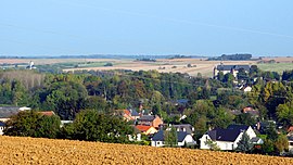 A general view of Chaourse and Montcornet | |
 Coat of arms | |
 Montcornet  Montcornet | |
Coordinates:  49°41′47″N 4°01′05″E / 49.6964°N 4.0181°E / 49.6964; 4.0181Coordinates: 49°41′47″N 4°01′05″E / 49.6964°N 4.0181°E / 49.6964; 4.0181 49°41′47″N 4°01′05″E / 49.6964°N 4.0181°E / 49.6964; 4.0181Coordinates: 49°41′47″N 4°01′05″E / 49.6964°N 4.0181°E / 49.6964; 4.0181 | |
| Country | France |
| Region | Hauts-de-France |
| Department | Aisne |
| Arrondissement | Vervins |
| Canton | Vervins |
| Intercommunality | Portes de la Thiérache |
| Government | |
| • Mayor (2020–2026) | Thomas Hennequin |
| Area 1 | 5.74 km2 (2.22 sq mi) |
| Population (Jan. 2018)[1] | 1,328 |
| • Density | 230/km2 (600/sq mi) |
| Time zone | UTC+01:00 (CET) |
| • Summer (DST) | UTC+02:00 (CEST) |
| INSEE/Postal code | 02502 /02340 |
| Elevation | 108–177 m (354–581 ft) (avg. 112 m or 367 ft) |
| 1 French Land Register data, which excludes lakes, ponds, glaciers > 1 km2 (0.386 sq mi or 247 acres) and river estuaries. | |

Montcornet (French pronunciation: [mɔ̃kɔʁnɛ]) is a commune in the Aisne department in Hauts-de-France in northern France.
Battle of Montcornet[]
Main article: Battle of Montcornet
On 14 May 1940, Charles de Gaulle was given command of the new 4e Division cuirassée and ordered to execute a counterattack toward Montcornet, with the objective of slowing the German advance. This was one of the only counterattacks of the French campaign that succeeded in repulsing the German troops.
Population[]
| Year | Pop. | ±% |
|---|---|---|
| 1962 | 1,439 | — |
| 1968 | 1,486 | +3.3% |
| 1975 | 1,623 | +9.2% |
| 1982 | 1,781 | +9.7% |
| 1990 | 1,755 | −1.5% |
| 1999 | 1,690 | −3.7% |
| 2008 | 1,634 | −3.3% |
See also[]
References[]
- ^ "Populations légales 2018". INSEE. 28 December 2020.
| Wikimedia Commons has media related to Montcornet, Aisne. |
show
| |
|---|---|
| Prefecture |
|
| Subprefectures |
|
| Other |
|
| show Authority control | |
|---|---|
| General |
|
| National libraries | |
This Vervins arrondissement geographical article is a stub. You can help Wikipedia by . |
- v
- t
Retrieved from ""
Categories:
- Communes of Aisne
- Vervins arrondissement geography stubs
Hidden categories:
- Articles to be expanded from December 2008
- All articles to be expanded
- Geography articles needing translation from French Wikipedia
- Articles with short description
- Short description is different from Wikidata
- Infobox mapframe without OSM relation ID on Wikidata
- Coordinates on Wikidata
- Pages using infobox settlement with image map1 but not image map
- Commons category link is on Wikidata
- Articles with VIAF identifiers
- Articles with LCCN identifiers
- Articles with WorldCat-VIAF identifiers
- Aisne communes articles needing translation from French Wikipedia
- All stub articles
- Pages using the Kartographer extension