[3] Name on the Register
Image
Date listed[4]
Location
City or town
Description
1
November 7, 1976 (#76000845 ) 8 miles northeast of Paris on LaRue Rd. 38°17′44″N 84°16′32″W / 38.295556°N 84.275556°W / 38.295556; -84.275556 (Airy Castle ) Paris
2
Upload image February 11, 1993 (#93000050 ) 795 Bethlehem Rd. 38°09′56″N 84°15′56″W / 38.165556°N 84.265556°W / 38.165556; -84.265556 (Jacob Aker Farm ) Paris
3
July 24, 1975 (#75000735 ) Off U.S. Route 68 near its junction with U.S. Route 460 38°13′12″N 84°14′08″W / 38.220000°N 84.235556°W / 38.220000; -84.235556 (Allen-Alexander House ) Paris
4
Bayless Quarters Upload image June 23, 1983 (#83002556 ) Kentucky Route 13 38°14′39″N 84°05′40″W / 38.244167°N 84.0945833°W / 38.244167; -84.0945833 (Bayless Quarters ) North Middletown
5
Bourbon County Confederate Monument
July 17, 1997 (#97000719 ) 0.5 miles northeast of the junction of U.S. Route 460 and 38°12′10″N 84°15′55″W / 38.202778°N 84.265278°W / 38.202778; -84.265278 (Bourbon County Confederate Monument ) Paris
6
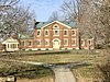
Bourbon County Courthouse
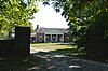
December 31, 1974 (#74000851 ) Courthouse Sq. 38°12′48″N 84°15′00″W / 38.213333°N 84.25°W / 38.213333; -84.25 (Bourbon County Courthouse ) Paris
7
Buckner Site (15BB12) Upload image January 27, 1983 (#83002557 ) Address Restricted Paris
8
Walker Buckner House
March 14, 1997 (#97000232 ) 1500 Cane Ridge Rd. 38°11′59″N 84°07′57″W / 38.199722°N 84.1325°W / 38.199722; -84.1325 (Walker Buckner House ) Paris
9
June 25, 2003 (#02001463 ) Cane Ridge Rd. 38°12′21″N 84°08′19″W / 38.205833°N 84.138611°W / 38.205833; -84.138611 (Cane Ridge Rural Historic District ) Paris
10
Thomas Champ House
June 19, 2003 (#03000256 ) Lexington and Maysville Rd. 38°15′39″N 84°11′29″W / 38.260833°N 84.191389°W / 38.260833; -84.191389 (Thomas Champ House ) Paris
11
Dr. Henry Clay House Upload image August 22, 1983 (#83002558 ) Off Kentucky Route 227 38°08′18″N 84°13′53″W / 38.138333°N 84.231389°W / 38.138333; -84.231389 (Dr. Henry Clay House ) Paris
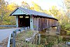
12
Colville Covered Bridge
December 30, 1974 (#74000850 ) 4 miles northwest of Millersburg over Hinkston Creek 38°19′29″N 84°12′12″W / 38.324722°N 84.203333°W / 38.324722; -84.203333 (Colville Covered Bridge ) Millersburg
13
Cooper's Run Baptist Church Upload image June 23, 1983 (#83002559 ) Off U.S. Route 27 38°15′13″N 84°16′25″W / 38.253611°N 84.273611°W / 38.253611; -84.273611 (Cooper's Run Baptist Church ) Shawhan
14
Cooper's Run Rural Historic District
December 23, 1998 (#98001493 ) Roughly along and included within Clay Kiser Rd., Paris-Cynthiana Rd., and U.S. Route 460 38°14′35″N 84°18′18″W / 38.243056°N 84.305°W / 38.243056; -84.305 (Cooper's Run Rural Historic District ) Paris
15
Upload image February 25, 1979 (#79000965 ) North of Shawhan on Shawhan-Ruddles Mill Pike 38°19′05″N 84°15′56″W / 38.318056°N 84.265556°W / 38.318056; -84.265556 (William David House ) Shawhan
16
December 15, 1989 (#89002123 ) Roughly bounded by 2nd St., Pleasant St., Main St., High St., and 12th St. 38°12′33″N 84°15′10″W / 38.209167°N 84.252778°W / 38.209167; -84.252778 (Downtown Paris Historic District ) Paris
17
June 23, 1988 (#88000902 ) Duncan, Stoner, Vine, and Massie Sts. 38°12′35″N 84°14′49″W / 38.209722°N 84.246944°W / 38.209722; -84.246944 (Duncan Avenue Historic District ) Paris
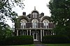
18
April 11, 1973 (#73000783 ) 323 High St. 38°12′47″N 84°15′02″W / 38.213056°N 84.250556°W / 38.213056; -84.250556 (Duncan Tavern ) Paris
19
October 2, 1973 (#73000784 ) 421 High St. 38°12′44″N 84°15′05″W / 38.212222°N 84.251389°W / 38.212222; -84.251389 (Eades Tavern ) Paris
20
Upload image June 23, 1983 (#83002560 ) Off Cook Rd. 38°18′56″N 84°16′37″W / 38.315556°N 84.276944°W / 38.315556; -84.276944 (James Eales House ) Shawhan
21
Upload image February 8, 1978 (#78001302 ) South of Paris on Kentucky Route 4 38°07′05″N 84°14′45″W / 38.118056°N 84.245833°W / 38.118056; -84.245833 (Escondida ) Paris
22
Upload image June 23, 1983 (#83002561 ) Peacock Pike 38°15′17″N 84°15′47″W / 38.254722°N 84.263056°W / 38.254722; -84.263056 (James Garrard House ) Shawhan
23
Upload image January 11, 1996 (#95001513 ) 1004 Thatchers Mill Rd. 38°06′30″N 84°08′12″W / 38.108333°N 84.136667°W / 38.108333; -84.136667 (Glen Oak ) Paris
24
The Grange
April 11, 1973 (#73000786 ) 4 miles north of Paris on U.S. Route 68 38°15′13″N 84°11′50″W / 38.253611°N 84.197222°W / 38.253611; -84.197222 (The Grange ) Paris
25
Upload image August 22, 1983 (#83002562 ) Off U.S. Route 460 38°10′17″N 84°07′23″W / 38.171389°N 84.123056°W / 38.171389; -84.123056 (Ephram Harrod House ) North Middletown
26
Upload image March 24, 2000 (#00000277 ) 1165 N. Middletown Rd. 38°12′04″N 84°11′20″W / 38.201111°N 84.188889°W / 38.201111; -84.188889 (Hillside Farm ) Paris
27
June 23, 1983 (#83002563 ) Kentucky Route 537 38°12′18″N 84°04′06″W / 38.205°N 84.068333°W / 38.205; -84.068333 (Hopkins House ) North Middletown
28
March 25, 2008 (#08000209 ) 1975 Georgetown Rd. 38°13′13″N 84°21′03″W / 38.220278°N 84.350833°W / 38.220278; -84.350833 (Johnston's Inn ) Paris
29
Upload image June 23, 1983 (#83002564 ) Off 38°16′18″N 84°14′12″W / 38.271667°N 84.236667°W / 38.271667; -84.236667 (Joseph Kennedy House ) Shawhan
30
Thomas Kennedy House Upload image December 8, 1980 (#80001484 ) Southeast of Paris on Paris-Winchester Rd. 38°10′06″N 84°13′49″W / 38.168333°N 84.230278°W / 38.168333; -84.230278 (Thomas Kennedy House ) Paris
31
December 12, 1977 (#77000601 ) North of Paris on Peacock Rd. 38°16′35″N 84°16′43″W / 38.276389°N 84.278611°W / 38.276389; -84.278611 (Kiser Station ) Paris
32
August 6, 2014 (#14000457 ) 41 E. Main St. 38°12′50″N 84°14′55″W / 38.2139°N 84.2487°W / 38.2139; -84.2487 (James Kiser House ) Paris
33
March 31, 2004 (#04000246 ) Along Little Rock-Jackstown and Soper Rds. 38°13′06″N 84°03′20″W / 38.218333°N 84.055556°W / 38.218333; -84.055556 (Little Rock-Jackstown Road Rural Historic District ) Little Rock
34
Upload image August 2, 1978 (#78001303 ) South of Paris off Kentucky Route 956 38°05′46″N 84°13′13″W / 38.096111°N 84.220278°W / 38.096111; -84.220278 (Loudoun Hall ) Paris
35
Upload image June 23, 1983 (#83002565 ) Off 38°18′41″N 84°15′28″W / 38.311389°N 84.257778°W / 38.311389; -84.257778 (Rudolph Mauck House ) Shawhan
36
September 9, 1975 (#75000734 ) Main St. 38°17′56″N 84°09′01″W / 38.298889°N 84.150278°W / 38.298889; -84.150278 (McKee-Vimont Row Houses ) Millersburg
37
Upload image June 23, 1983 (#83002566 ) 38°08′27″N 84°19′48″W / 38.140833°N 84.33°W / 38.140833; -84.33 (McLeod Spring House ) Paris
38
June 23, 1983 (#83002567 ) 38°18′21″N 84°14′18″W / 38.305833°N 84.238333°W / 38.305833; -84.238333 (Miller's House at Ruddels Mills ) Millersburg
39
April 10, 1986 (#86000697 ) Roughly bounded by College Ave., Miller, Second, and Trigg Sts. 38°18′08″N 84°08′48″W / 38.302222°N 84.146667°W / 38.302222; -84.146667 (Millersburg Historic District ) Millersburg
40
Owen-Gay Farm
March 13, 1997 (#97000163 ) Gay Rd., junction with Donaldson Rd. at the Clark County line 38°06′24″N 84°06′56″W / 38.106667°N 84.115556°W / 38.106667; -84.115556 (Owen-Gay Farm ) Winchester Extends into Clark County
41
Paris Cemetery Gatehouse
November 24, 1978 (#78001301 ) US 68 Bus. 38°12′07″N 84°15′46″W / 38.201944°N 84.262778°W / 38.201944; -84.262778 (Paris Cemetery Gatehouse ) Paris
42
Paris Courthouse Square Historic District
January 25, 1979 (#79000963 ) Courthouse Sq. and environs 38°12′47″N 84°15′00″W / 38.213056°N 84.25°W / 38.213056; -84.25 (Paris Courthouse Square Historic District ) Paris
43
April 11, 1973 (#73000785 ) Between 10th St. and Winchester Pike 38°12′23″N 84°15′03″W / 38.206389°N 84.250833°W / 38.206389; -84.250833 (Paris Railroad Depot ) Paris
44
April 22, 2003 (#03000257 ) Along See Rd., Kentucky Route 57 , and 38°11′32″N 84°01′32″W / 38.192222°N 84.025556°W / 38.192222; -84.025556 (Pocket Rural Historic District ) Sharpsburg
45
Upload image June 23, 1983 (#83002568 ) U.S. Route 460 38°11′39″N 84°10′46″W / 38.194167°N 84.179444°W / 38.194167; -84.179444 (Thomas Rodgers House ) Paris
46
June 23, 1983 (#83002569 ) Off Brentsville Rd. 38°16′07″N 84°20′28″W / 38.268611°N 84.341111°W / 38.268611; -84.341111 (Elias Rymill House ) Shawhan
47
Upload image August 9, 1979 (#79000964 ) West of Paris on Hume-Bedford Rd. 38°11′19″N 84°20′28″W / 38.188611°N 84.341111°W / 38.188611; -84.341111 (Sacred Home ) Paris
48
Upload image June 23, 1983 (#83002570 ) Off U.S. Route 68 38°17′00″N 84°07′18″W / 38.283333°N 84.121667°W / 38.283333; -84.121667 (Sandusky House ) Carlisle
49
Upload image June 23, 1983 (#83002571 ) Off 38°16′57″N 84°15′16″W / 38.2825°N 84.254444°W / 38.2825; -84.254444 (Laban Shipp House ) Shawhan
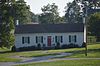
50
Snow Hill Upload image November 7, 1997 (#97001341 ) 4100 Little Rock-Jackstown Rd. 38°12′19″N 84°03′21″W / 38.205278°N 84.055833°W / 38.205278; -84.055833 (Snow Hill ) Little Rock
51
June 23, 1983 (#83002573 ) 38°16′05″N 84°18′26″W / 38.268056°N 84.307222°W / 38.268056; -84.307222 (Jacob Spears Distillery ) Shawhan
52
June 23, 1983 (#83002572 ) 38°16′04″N 84°18′30″W / 38.267778°N 84.308333°W / 38.267778; -84.308333 (Jacob Spears House ) Shawhan
53
June 23, 1983 (#83002574 ) 38°18′35″N 84°14′29″W / 38.309722°N 84.241389°W / 38.309722; -84.241389 (Joseph L. Stephens House ) Millersburg
54
Stoner Creek Rural Historic District Upload image May 2, 2001 (#01000449 ) Along Winchester, Stoney Point, Spears Mill, and N. Middletown Rds. 38°09′53″N 84°11′12″W / 38.164722°N 84.186667°W / 38.164722; -84.186667 (Stoner Creek Rural Historic District ) Paris
55
November 15, 1996 (#96001346 ) 573 Clay-Kiser Rd. 38°14′32″N 84°20′09″W / 38.242222°N 84.335833°W / 38.242222; -84.335833 (Sugar Grove ) Paris
56
March 30, 1995 (#95000302 ) 405 McNease Rd. 38°16′32″N 84°19′36″W / 38.275417°N 84.326528°W / 38.275417; -84.326528 (John Tucker House ) Paris
57
Upload image May 24, 2007 (#06001197 ) Millersburg-Ruddels Mills and Steele Ford Roads 38°18′18″N 84°10′32″W / 38.305000°N 84.175556°W / 38.305000; -84.175556 (West Millersburg Rural Historic District ) Millersburg
58
Upload image June 23, 1983 (#83002576 ) Kentucky Route 537 38°13′11″N 84°11′13″W / 38.219722°N 84.186944°W / 38.219722; -84.186944 (Widow McDowell House ) Paris
59
Upload image June 23, 1983 (#83002577 ) Off Kentucky Routes 32 /36 38°21′45″N 84°11′02″W / 38.3625°N 84.183889°W / 38.3625; -84.183889 (Hubbard Williams House ) Millersburg
60
Upload image December 2, 1996 (#96001345 ) Peacock Rd., approximately 2 miles north of Paris 38°14′41″N 84°15′23″W / 38.244722°N 84.256389°W / 38.244722; -84.256389 (Woodlawn ) Paris
61
October 8, 1976 (#76000846 ) 1 mile southwest of Paris on U.S. Route 27 38°11′27″N 84°16′49″W / 38.190972°N 84.280278°W / 38.190972; -84.280278 (Capt. James Wright House and Cabin ) Paris