[3] Name on the Register
Image
Date listed[4]
Location
City or town
Description
1
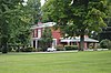
John Arnold House Upload image June 23, 1983 (#83002777 ) Off Kentucky Route 1295 37°36′45″N 84°28′49″W / 37.6125°N 84.480278°W / 37.6125; -84.480278 (John Arnold House ) Paint Lick
2
Billy Ball House Upload image March 26, 1984 (#84001434 ) 209 Richmond St. 37°37′10″N 84°34′34″W / 37.619306°N 84.576111°W / 37.619306; -84.576111 (Billy Ball House ) Lancaster Log structure built in 1830s; vacant in 1983; may no longer exist.
3
Barlow House Upload image June 17, 1985 (#85001276 ) Danville Rd. 37°38′08″N 84°36′54″W / 37.635556°N 84.615000°W / 37.635556; -84.615000 (Barlow House ) Lancaster
4
Upload image June 17, 1985 (#85001277 ) Polly's Bend Rd. 37°48′13″N 84°38′21″W / 37.803611°N 84.639167°W / 37.803611; -84.639167 (Calvin Blakeman House ) Lancaster
5
Upload image June 17, 1985 (#85001278 ) Junction of Boone's Creek and Kentucky Route 52 37°37′53″N 84°37′00″W / 37.631389°N 84.616667°W / 37.631389; -84.616667 (Bonta-Owsley House ) Lancaster
6
April 14, 1975 (#75000761 ) 106 W. Maple St. 37°37′15″N 84°34′47″W / 37.620972°N 84.579722°W / 37.620972; -84.579722 (Boyle-Robertson-Letcher House ) Lancaster
7
November 5, 1974 (#74000876 ) Lexington St. 37°37′19″N 84°34′41″W / 37.621944°N 84.578056°W / 37.621944; -84.578056 (Gov. William O. Bradley House ) Lancaster
8
Bryantsville Methodist Church
June 17, 1985 (#85001279 ) U.S. Route 27 37°42′48″N 84°39′03″W / 37.713333°N 84.650833°W / 37.713333; -84.650833 (Bryantsville Methodist Church ) Lancaster
9
Upload image June 17, 1985 (#85001280 ) Off U.S. Route 27 37°42′46″N 84°39′00″W / 37.712778°N 84.65°W / 37.712778; -84.65 (Bryantsville Post Office and Store ) Bryantsville
10
June 17, 1985 (#85001281 ) Kentucky Route 52 37°37′02″N 84°24′30″W / 37.617222°N 84.408333°W / 37.617222; -84.408333 (Calico & Brown General Store ) Paint Lick
11
Dalton House Upload image June 17, 1985 (#85001282 ) Kentucky Route 39 37°35′36″N 84°34′21″W / 37.593333°N 84.572500°W / 37.593333; -84.572500 (Dalton House ) Lancaster
12
Denny Place
March 26, 1984 (#84001439 ) 217 Lexington St. 37°37′25″N 84°34′43″W / 37.623611°N 84.578611°W / 37.623611; -84.578611 (Denny Place ) Lancaster
13
Dunn-Watkins House Upload image June 17, 1985 (#85001283 ) Danville Rd. 37°37′54″N 84°36′04″W / �� 37.631667°N 84.601111°W / 37.631667; -84.601111 (Dunn-Watkins House ) Lancaster
14
Upload image November 25, 2008 (#08000650 ) 572 Danville St. 37°37′20″N 84°35′36″W / 37.62222°N 84.59333°W / 37.62222; -84.59333 (Dr. Edwards House ) Lancaster
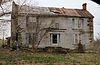
15
Upload image August 28, 1975 (#75000762 ) Northwest of Lancaster on Burdett's Knob Rd. off U.S. Route 27 37°41′14″N 84°38′29″W / 37.687222°N 84.641389°W / 37.687222; -84.641389 (John Floyd House ) Lancaster
16
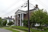
Garrard County Jail
March 26, 1984 (#84001442 ) Stanford St. 37°37′06″N 84°34′43″W / 37.618333°N 84.578611°W / 37.618333; -84.578611 (Garrard County Jail ) Lancaster
17
Garrard Mills
March 26, 1984 (#84001447 ) 205 E. Buford St. 37°37′05″N 84°34′35″W / 37.618056°N 84.576389°W / 37.618056; -84.576389 (Garrard Mills ) Lancaster
18
Upload image June 17, 1985 (#85001284 ) U.S. Route 27 37°41′39″N 84°39′43″W / 37.694167°N 84.661944°W / 37.694167; -84.661944 (Gulley Farm ) Lancaster
19
March 26, 1984 (#84001449 ) 107 Maple Ave. 37°37′14″N 84°34′48″W / 37.620556°N 84.580000°W / 37.620556; -84.580000 (Hamilton House ) Lancaster
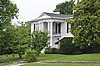
20
Roscoe Hamilton House Upload image June 17, 1985 (#85001285 ) Buena Vista Rd. 37°46′07″N 84°40′21″W / 37.768611°N 84.672500°W / 37.768611; -84.672500 (Roscoe Hamilton House ) Lancaster
21
March 26, 1984 (#84001451 ) 211 Lexington St. 37°37′23″N 84°34′43″W / 37.623056°N 84.578611°W / 37.623056; -84.578611 (J.C. Hemphill House ) Lancaster
22
March 26, 1984 (#84001455 ) 106 Hill Court 37°37′29″N 84°34′39″W / 37.624722°N 84.577500°W / 37.624722; -84.577500 (Dr. Oliver Perry Hill House ) Lancaster
23
John Hutcherson House Upload image June 23, 1983 (#83002778 ) Off Kentucky Route 39 37°40′21″N 84°32′17″W / 37.6725°N 84.538056°W / 37.6725; -84.538056 (John Hutcherson House ) Buckeye
24
Jennings-Salter House
February 21, 1980 (#80001531 ) 208 Danville St. 37°37′11″N 84°34′51″W / 37.619722°N 84.580833°W / 37.619722; -84.580833 (Jennings-Salter House ) Lancaster
25
Upload image June 23, 1983 (#83002782 ) Off Kentucky Route 39 37°31′50″N 84°30′51″W / 37.530556°N 84.514167°W / 37.530556; -84.514167 (Thomas Kings, III House ) Lancaster
26
Lancaster Cemetery
March 26, 1984 (#84001458 ) Campbell, Crab Orchard, and Richmond Sts. 37°37′00″N 84°34′30″W / 37.616528°N 84.575000°W / 37.616528; -84.575000 (Lancaster Cemetery ) Lancaster
27
Lancaster Commercial Historic District
March 26, 1984 (#84001461 ) Danville, Lexington, Richmond, and Stanford Sts. 37��37′10″N 84°34′46″W / 37.619444°N 84.579444°W / 37.619444; -84.579444 (Lancaster Commercial Historic District ) Lancaster
28
Upload image June 17, 1985 (#85001286 ) Polly's Bend Rd. 37°46′42″N 84°39′26″W / 37.778333°N 84.657222°W / 37.778333; -84.657222 (Lane Farm ) Lancaster
29
March 26, 1984 (#84001464 ) 222 Lexington St. 37°37′24″N 84°34′38″W / 37.623333°N 84.577222°W / 37.623333; -84.577222 (Judge V.A. Lear House ) Lancaster
30
Upload image June 23, 1983 (#83002779 ) Off 37°43′38″N 84°39′58″W / 37.727222°N 84.666111°W / 37.727222; -84.666111 (John Leavell Quarters ) Bryantsville
31
March 26, 1984 (#84001467 ) 108 S. Campbell St. 37°37′05″N 84°34′40″W / 37.618194°N 84.577639°W / 37.618194; -84.577639 (Male Academy ) Lancaster
32
March 26, 1984 (#84001470 ) 213 Lexington St. 37°37′24″N 84°34′43″W / 37.623333°N 84.578611°W / 37.623333; -84.578611 (Sue Shelby Mason House ) Lancaster
33
Upload image June 17, 1985 (#85001287 ) Broadus Branch Rd. 37°38′18″N 84°25′57″W / 37.638333°N 84.4325°W / 37.638333; -84.4325 (Isaac Metcalf House ) Lancaster
34
Methodist Episcopal Church
July 2, 1984 (#84001473 ) Stanford St. 37°37′05″N 84°34′45″W / 37.618056°N 84.579167°W / 37.618056; -84.579167 (Methodist Episcopal Church ) Lancaster
35
Upload image June 17, 1985 (#85001288 ) Junction of Kentucky Routes 21 and 52 37°36′58″N 84°24′23″W / 37.616111°N 84.406389°W / 37.616111; -84.406389 (William Miller Place ) Paint Lick
36
Mt. Olivet Methodist Church Upload image June 17, 1985 (#85001289 ) Off Kentucky Route 152 37°44′47″N 84°39′07″W / 37.746389°N 84.651944°W / 37.746389; -84.651944 (Mt. Olivet Methodist Church ) Lancaster
37
Carry A. Nation House
December 16, 1977 (#77000620 ) West of Lancaster on Fisher Ford Rd. 37°42′48″N 84°43′13″W / 37.713333°N 84.720278°W / 37.713333; -84.720278 (Carry A. Nation House ) Lancaster Childhood home of temperance movement leader Carrie Nation .
38
Gov. William Owsley House
May 6, 1975 (#75000763 ) 0.5 miles south of Lancaster on U.S. Route 27 37°36′33″N 84°34′50″W / 37.609167°N 84.580556°W / 37.609167; -84.580556 (Gov. William Owsley House ) Lancaster
39
Upload image February 24, 2014 (#14000017 ) Roughly along Richmond Rd. 37°37′03″N 84°24′29″W / 37.617542°N 84.408056°W / 37.617542; -84.408056 (Paint Lick Commercial District ) Paint Lick
40
Paint Lick Presbyterian Church Upload image June 17, 1985 (#85001290 ) Kentucky Route 52 37°35′12″N 84°26′11″W / 37.586667°N 84.436389°W / 37.586667; -84.436389 (Paint Lick Presbyterian Church ) Paint Lick
41
Upload image April 10, 2007 (#07000284 ) 10973 Richmond Rd. 37°36′35″N 84°24′52″W / 37.609722°N 84.414444°W / 37.609722; -84.414444 (Paint Lick School ) Paint Lick
42
Upload image June 17, 1985 (#85001291 ) U.S. Route 27 37°39′18″N 84°36′23″W / 37.655°N 84.606389°W / 37.655; -84.606389 (Parke-Moore House ) Lancaster
43
Upload image June 17, 1985 (#85001292 ) Locust Lane 37°40′38″N 84°37′08″W / 37.677222°N 84.618889°W / 37.677222; -84.618889 (William Parks House ) Lancaster
44
March 26, 1984 (#84001481 ) 215 Buford St. 37°37′05″N 84°34′55″W / 37.618194°N 84.581944°W / 37.618194; -84.581944 (Peacock House ) Lancaster
45
March 26, 1984 (#84001482 ) 212 Danville St. 37°37′11″N 84°34′54″W / 37.619861°N 84.581667°W / 37.619861; -84.581667 (Peacock-Miller House ) Lancaster
46
Upload image September 28, 1989 (#85003767 ) Crab Orchard Rd. 4.3 miles south of Lancaster 37°34′13″N 84°32′44″W / 37.570278°N 84.545556°W / 37.570278; -84.545556 (Lucien Perkins Farm ) Lancaster
47
June 17, 1985 (#85001293 ) Gilbert's Creek 37°34′22″N 84°34′01″W / 37.572778°N 84.566944°W / 37.572778; -84.566944 (Perkins-Daniel House ) Lancaster
48
Upload image March 26, 1984 (#84001484 ) 404 Danville St. 37°37′16″N 84°35′21″W / 37.621111°N 84.589167°W / 37.621111; -84.589167 (Petrie House ) Lancaster
49
Upload image June 23, 1983 (#83002780 ) U.S. Route 27 37°44′39″N 84°37′41″W / 37.744167°N 84.628056°W / 37.744167; -84.628056 (Proctor House ) Bryantsville
50
June 17, 1985 (#85001294 ) 2596 Old Danville Rd. 37°36′19″N 84°37′20″W / 37.605278°N 84.622222°W / 37.605278; -84.622222 (Rankin Place ) Lancaster
51
Upload image June 17, 1985 (#85001295 ) Jess Ray Rd. 37°41′05″N 84°32′47″W / 37.684722°N 84.546389°W / 37.684722; -84.546389 (Ray House ) Lancaster
52
June 17, 1985 (#85001296 ) Kentucky Route 39 37°34′56″N 84°33′46″W / 37.582222°N 84.562778°W / 37.582222; -84.562778 (Tom Salter House ) Lancaster
53
Upload image June 17, 1985 (#85001297 ) Nina Ridge 37°41′05″N 84°28′37″W / 37.684722°N 84.476944°W / 37.684722; -84.476944 (Sebastian Log House ) Lancaster
54
Upload image June 17, 1985 (#85001298 ) Fisher Ford Rd. 37°42′18″N 84°43′19″W / 37.705°N 84.721944°W / 37.705; -84.721944 (Sharp House ) Lancaster
55
Upload image June 17, 1985 (#85001299 ) Junction of Kentucky Routes 52 and 37°35′32″N 84°29′58″W / 37.592222°N 84.499444°W / 37.592222; -84.499444 (Smith House ) Paint Lick
56
Upload image June 23, 1983 (#83002781 ) Off U.S. Route 27 37°43′18″N 84°40′12″W / 37.721667°N 84.67°W / 37.721667; -84.67 (James Smith Tanyard ) Bryantsville
57
Upload image June 17, 1985 (#85001300 ) Ballard Lane-Tanyard Branch 37°43′38″N 84°39′58″W / 37.727222°N 84.666111°W / 37.727222; -84.666111 (Spring Garden-John Leavell ) Bryantsville
58
Upload image June 17, 1985 (#85001301 ) Kentucky Route 39 37°44′56″N 84°31′15″W / 37.748889°N 84.520833°W / 37.748889; -84.520833 (Stapp Homeplace ) Lancaster
59
Upload image June 17, 1985 (#85001303 ) Kentucky Route 39 37°45′25″N 84°31′32″W / 37.756944°N 84.525556°W / 37.756944; -84.525556 (Paris Teater House ) Lancaster
60
Upload image June 17, 1985 (#85001302 ) Kentucky Route 39 37°40′29″N 84°30′52″W / 37.674722°N 84.514444°W / 37.674722; -84.514444 (William Teater House ) Teatersville
61
Upload image June 17, 1985 (#85001304 ) Wolf Trail Road (Kentucky Route 563 ) 37°44′32″N 84°32′28″W / 37.742222°N 84.541111°W / 37.742222; -84.541111 (Smith Thompson Log House ) Lancaster
62
Upload image June 17, 1985 (#85001305 ) Sugar Creek 37°44′02″N 84°33′38″W / 37.733889°N 84.560556°W / 37.733889; -84.560556 (Walden Place ) Lancaster
63
Walker House Upload image June 17, 1985 (#85001306 ) Kentucky Route 1295 37°38′44″N 84°27′45″W / 37.645556°N 84.4625°W / 37.645556; -84.4625 (Walker House ) Lancaster
64
Michael Wallace House Upload image June 23, 1983 (#83002783 ) Broadus Branch Rd. 37°37′33″N 84°26′09″W / 37.625833°N 84.435833°W / 37.625833; -84.435833 (Michael Wallace House ) Kirksville
65
Upload image March 26, 1984 (#84001490 ) Stanford St. 37°36′55″N 84°34′53″W / 37.615278°N 84.581389°W / 37.615278; -84.581389 (Wearren Place ) Lancaster
66
Wherritt House
March 26, 1984 (#84001494 ) 210 Lexington St. 37°37′16″N 84°34′42″W / 37.621111°N 84.578333°W / 37.621111; -84.578333 (Wherritt House ) Lancaster
67
Upload image June 17, 1985 (#85001307 ) Off Polly's Bend Rd. 37°45′55″N 84°40′05″W / 37.765278°N 84.668056°W / 37.765278; -84.668056 (Paul Wilson Place ) Lancaster