[3] Name on the Register
Image
Date listed[4]
Location
City or town
Description
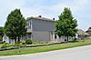
1
John R. Barber House Upload image February 10, 1989 (#88003423 ) West of Springfield on U.S. Route 150 37°42′49″N 85°15′50″W / 37.713611°N 85.263889°W / 37.713611; -85.263889 (John R. Barber House ) Springfield
2
Beech Fork Bridge, Mackville Road Upload image February 10, 1989 (#88003429 ) East of Springfield on Kentucky Route 152 37°42′15″N 85°08′46″W / 37.704167°N 85.146111°W / 37.704167; -85.146111 (Beech Fork Bridge, Mackville Road ) Springfield
3
Beechfork Presbyterian Church Upload image February 10, 1989 (#88003406 ) North of Springfield off Kentucky Route 55 37°45′14″N 85°10′30″W / 37.753889°N 85.175°W / 37.753889; -85.175 (Beechfork Presbyterian Church ) Springfield
4
Richard Berry, Jr., House Upload image February 10, 1989 (#88003400 ) North of Springfield on Kentucky Route 438 37°46′10″N 85°11′33″W / 37.769444°N 85.1925°W / 37.769444; -85.1925 (Richard Berry, Jr., House ) Springfield
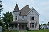
5
William Blackwell House
February 10, 1989 (#88003391 ) 138 Lebanon Hill 37°40′55″N 85°13′28″W / 37.681944°N 85.224306°W / 37.681944; -85.224306 (William Blackwell House ) Springfield
6
Stephen Cooke Brown House Upload image November 21, 1994 (#88003471 ) Kentucky Route 438 37°45′40″N 85°10′20″W / 37.761111°N 85.172222°W / 37.761111; -85.172222 (Stephen Cooke Brown House ) Springfield
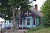
7
Upload image October 6, 1987 (#87002054 ) Off Kentucky Route 55 on Spaulding Lane 37°43′03″N 85°10′50″W / 37.7175°N 85.180556°W / 37.7175; -85.180556 (William Caldwell Kitchen ) Springfield
8
Cartwright Creek Bridge Upload image February 10, 1989 (#88003425 ) West of Springfield on Booker Rd. 37°39′34″N 85°16′23″W / 37.659444°N 85.273056°W / 37.659444; -85.273056 (Cartwright Creek Bridge ) Springfield
9
Clements House Upload image February 10, 1989 (#88003401 ) West of Springfield on U.S. Route 150 37°42′15″N 85°15′11″W / 37.704167°N 85.253056°W / 37.704167; -85.253056 (Clements House ) Springfield
10
Upload image February 10, 1989 (#88003413 ) Off U.S. Route 150 37°39′27″N 85°06′07″W / 37.6575°N 85.101944°W / 37.6575; -85.101944 (Cocanougher House ) Mackville
11
George Conner House Upload image February 10, 1989 (#88003402 ) Off U.S. Route 150 37°45′35″N 85°20′38″W / 37.759722°N 85.343889°W / 37.759722; -85.343889 (George Conner House ) Fredericktown
12
January 27, 1983 (#83002890 ) 333 E. Main St. 37°41′00″N 85°13′00″W / 37.683472°N 85.216667°W / 37.683472; -85.216667 (Covington Institute Teachers' Residence ) Springfield
13
Ed Cusick House Upload image February 10, 1989 (#88003426 ) West of Springfield on Bearwallow Rd. 37°42′59″N 85°21′59″W / 37.716389°N 85.366389°W / 37.716389; -85.366389 (Ed Cusick House ) Springfield
14
February 10, 1989 (#88003418 ) West of Springfield off U.S. Route 150 37°46′40″N 85°17′40″W / 37.777778°N 85.294444°W / 37.777778; -85.294444 (Doe Run Trestle ) Springfield
15
February 10, 1989 (#88003393 ) 206 Lincoln Park Rd. 37°41′11″N 85°13′18″W / 37.686389°N 85.221667°W / 37.686389; -85.221667 (Duncan House ) Springfield
16
Upload image February 10, 1989 (#88003433 ) Highway 1183 37°42′52″N 85°23′15″W / 37.714444°N 85.3875°W / 37.714444; -85.3875 (Edelen House ) Springfield
17
Upload image December 20, 1977 (#77000658 ) Kentucky Route 55 37°40′41″N 85°13′35″W / 37.678056°N 85.226389°W / 37.678056; -85.226389 (Elmwood ) Springfield
18
Farmer's Bank of Mackville
February 10, 1989 (#88003431 ) Kentucky Route 152 37°43′41″N 85°04′00″W / 37.728056°N 85.066667°W / 37.728056; -85.066667 (Farmer's Bank of Mackville ) Mackville
19
Upload image February 10, 1989 (#88003422 ) Highway 1183 37°42′13″N 85°19′06″W / 37.703611°N 85.318333°W / 37.703611; -85.318333 (Fields' House ) Springfield
20
Upload image February 10, 1989 (#88003416 ) Kentucky Route 55 37°49′07″N 85°17′38″W / 37.818611°N 85.293889°W / 37.818611; -85.293889 (Glenn Cottage Tract ) Maud
21
Upload image February 10, 1989 (#88003398 ) South of Mooresville off Kentucky Route 55 37°46′54″N 85°15′42″W / 37.781667°N 85.261667°W / 37.781667; -85.261667 (Gregory-Barlow Place ) Mooresville
22
Upload image January 17, 1978 (#78001411 ) North of Springfield off Kentucky Route 55 37°44′53″N 85°16′39″W / 37.748056°N 85.2775°W / 37.748056; -85.2775 (Grundy Houses ) Springfield
23
Upload image July 22, 1993 (#93000695 ) U.S. Route 150 0.7 miles west of Parker's Branch crossing37°45′56″N 85°19′23″W / 37.765556°N 85.323056°W / 37.765556; -85.323056 (Hamilton Farm ) Springfield
24
Upload image February 10, 1989 (#88003403 ) West of Springfield on U.S. Route 150 37°42′56″N 85°16′11″W / 37.715556°N 85.269722°W / 37.715556; -85.269722 (Thomas H. Hamilton House ) Springfield
25
Upload image February 7, 2008 (#08000013 ) 3067 Beechland Rd. 37°45′58″N 85°12′32″W / 37.766111°N 85.208889°W / 37.766111; -85.208889 (Hatchett Tobacco Barn ) Springfield
26
Holy Rosary Church
February 10, 1989 (#88003409 ) 37°42′47″N 85°23′15″W / 37.713056°N 85.3875°W / 37.713056; -85.3875 (Holy Rosary Church ) Manton
27
Johnson's Chapel AME Church
February 10, 1989 (#88003396 ) E. High St. 37°41′04″N 85°13′00″W / 37.684306°N 85.216667°W / 37.684306; -85.216667 (Johnson's Chapel AME Church ) Springfield
28
Upload image August 5, 2010 (#10000528 ) 101 Kalarama Dr. 37°41′42″N 85°12′27″W / 37.695000°N 85.207500°W / 37.695000; -85.207500 (Kalarama Saddlebred Horse Farm ) Springfield
29
February 10, 1989 (#88003417 ) Hog Run, Booker Station 37°46′49″N 85°18′09″W / 37.780278°N 85.3025°W / 37.780278; -85.3025 (Kendrick-Croake House ) Maud
30
February 10, 1989 (#88003421 ) Off U.S. Route 150 37°45′56″N 85°18′36″W / 37.765556°N 85.31°W / 37.765556; -85.31 (Kendrick-Tucker-Barber House ) Mooresville
31
Mordecai Lincoln House
August 21, 1972 (#72000547 ) 5.9 miles north of Springfield on Kentucky Route 528 37°44′54″N 85°12′35″W / 37.748333°N 85.209722°W / 37.748333; -85.209722 (Mordecai Lincoln House ) Springfield
32
Upload image February 10, 1989 (#88003404 ) North of Springfield off Kentucky Route 438 37°46′24″N 85°12′45″W / 37.773333°N 85.2125°W / 37.773333; -85.2125 (John Litsey House ) Springfield
33
Upload image February 10, 1989 (#88003414 ) Hardesty-Polin Rd. over Long Lick Creek 37°48′38″N 85°12′45″W / 37.810556°N 85.2125°W / 37.810556; -85.2125 (Long Lick Creek Bridge ) Willisburg
34
Pat Lyddan House Upload image February 10, 1989 (#88003420 ) South of Mooresville on Kentucky Route 55 37°47′26″N 85°15′27″W / 37.790556°N 85.2575°W / 37.790556; -85.2575 (Pat Lyddan House ) Mooresville
35
January 22, 2014 (#12001203 ) Along Kentucky Routes 152 and 433 37°44′13″N 85°03′59″W / 37.736809°N 85.066507°W / 37.736809; -85.066507 (Mackville Historic District ) Mackville
36
Upload image August 5, 2010 (#10000527 ) 3216 Perryville Rd. 37°39′57″N 85°10′57″W / 37.665833°N 85.1825°W / 37.665833; -85.1825 (Maple Grove ) Springfield vicinity
37
Upload image February 10, 1989 (#88003405 ) East of Springfield off U.S. Route 150 37°39′40″N 85°09′58″W / 37.661111°N 85.166111°W / 37.661111; -85.166111 (Archibald Scott Mayes House ) Springfield
38
December 11, 1978 (#78001412 ) 202 Lincoln Park Rd. 37°41′09″N 85°13′18″W / 37.685972°N 85.221667°W / 37.685972; -85.221667 (William C. McChord House ) Springfield
39
Upload image February 10, 1989 (#88003397 ) East of Springfield on U.S. Route 150 37°39′42″N 85°11′02″W / 37.661667°N 85.183889°W / 37.661667; -85.183889 (T.I. McElroy House ) Springfield
40
February 10, 1989 (#88003392 ) 321 E. High St. 37°41′06″N 85°13′02″W / 37.685000°N 85.217222°W / 37.685000; -85.217222 (Wilson McElroy House ) Springfield
41
Mount Zion Covered Bridge
March 26, 1976 (#76000958 ) North of Mooresville on Kentucky Route 458 37°49′40″N 85°15′23″W / 37.827778°N 85.256389°W / 37.827778; -85.256389 (Mount Zion Covered Bridge ) Mooresville Completed 1871. Destroyed 2021.
42
Upload image February 10, 1989 (#88003412 ) East of Springfield on Kentucky Route 152 37°41′39″N 85°10′51″W / 37.694167°N 85.180833°W / 37.694167; -85.180833 (Parrot House ) Springfield
43
Upload image February 10, 1989 (#88003407 ) Off Kentucky Route 55 37°48′59″N 85°16′54″W / 37.816389°N 85.281667°W / 37.816389; -85.281667 (Benjamin Pile House ) Springfield
44
May 13, 1976 (#76000959 ) 207 Walnut St. 37°41′08″N 85°13′11″W / 37.685556°N 85.219722°W / 37.685556; -85.219722 (John Pope House ) Springfield
45
Upload image February 10, 1989 (#88003415 ) Off Kentucky Route 55 37°49′12″N 85°17′28″W / 37.82°N 85.291111°W / 37.82; -85.291111 (Ray-Wakefield House ) Maud
46
Upload image February 10, 1989 (#88003424 ) West of Springfield off Kentucky Route 152 37°40′42″N 85°21′02″W / 37.678333°N 85.350556°W / 37.678333; -85.350556 (Road Run School ) Springfield
47
Upload image January 8, 1987 (#87000164 ) U.S. Route 150 37°45′32″N 85°18′55″W / 37.758889°N 85.315278°W / 37.758889; -85.315278 (Round Stone Smokehouse ) Fredericktown
48
St. Catherine of Sienna Convent Upload image February 10, 1989 (#88003395 ) West of Springfield on U.S. Route 150 37°42′29″N 85°15′38″W / 37.708056°N 85.260556°W / 37.708056; -85.260556 (St. Catherine of Sienna Convent ) Springfield
49
St. Dominic's Catholic Church
February 10, 1989 (#88003388 ) Main St. 37°41′14″N 85°13′30″W / 37.687222°N 85.225°W / 37.687222; -85.225 (St. Dominic's Catholic Church ) Springfield
50
St. Rose Roman Catholic Church Complex
February 14, 1978 (#78001413 ) West of Springfield off U.S. Route 150 37°41′36″N 85°15′49″W / 37.693333°N 85.263611°W / 37.693333; -85.263611 (St. Rose Roman Catholic Church Complex ) Springfield
51
Upload image February 10, 1989 (#88003427 ) Southeast of Springfield 37°38′05″N 85°10′39″W / 37.634722°N 85.1775°W / 37.634722; -85.1775 (Simms-Edelen House ) Springfield
52
Upload image February 10, 1989 (#88003428 ) East of Springfield off Kentucky Route 152 37°42′11″N 85°09′52″W / 37.703056°N 85.164444°W / 37.703056; -85.164444 (Simms-Mattingly House ) Springfield
53
February 10, 1989 (#88003408 ) South of Springfield on Rineltown-Simmstown Rd. 37°38′05″N 85°11′08″W / 37.634722°N 85.185556°W / 37.634722; -85.185556 (Simmstown ) Springfield
54
Upload image February 10, 1989 (#88003411 ) West of Springfield on U.S. Route 150 37°41′58″N 85°15′02″W / 37.699444°N 85.250556°W / 37.699444; -85.250556 (Levi J. Smith House ) Springfield
55
March 24, 2000 (#00000283 ) 126 Armory Hill Rd. 37°40′57″N 85°13′33″W / 37.682500°N 85.225833°W / 37.682500; -85.225833 (Springfield Armory ) Springfield
56
Springfield Baptist Church
February 10, 1989 (#88003394 ) Lincoln Park Rd. 37°41′11″N 85°13′15″W / 37.686389°N 85.220833°W / 37.686389; -85.220833 (Springfield Baptist Church ) Springfield
57
February 10, 1989 (#88003389 ) Mackville and Perry Rds. 37°40′55″N 85°12′52″W / 37.681944°N 85.214444°W / 37.681944; -85.214444 (Springfield Graded School ) Springfield
58
February 10, 1989 (#88003434 ) Roughly bounded by McCord, Walnut, Ballard and Doctor Sts.; also roughly Commercial Ave. to College St., and McCord and High Sts. to E. Depot St. 37°41′07″N 85°13′19″W / 37.685278°N 85.221944°W / 37.685278; -85.221944 (Springfield Main Street Historic District ) Springfield Originally the Springfield Historic Commercial District, a small downtown district; second set of addresses represent a boundary increase of December 19, 2012 ,[5] [6]
59
Upload image February 10, 1989 (#88003399 ) North of Willisburg on Hwy. 1796 37°51′50″N 85°07′28″W / 37.863889°N 85.124444°W / 37.863889; -85.124444 (Tatham Springs ) Willisburg
60
Upload image February 10, 1989 (#88003419 ) South of Mooresville on Kentucky Route 55 37°47′09″N 85°15′17″W / 37.785833°N 85.254722°W / 37.785833; -85.254722 (John Thomas House ) Mooresville
61
Upload image February 10, 1989 (#88003430 ) East of Springfield on Mackville Rd. 37°43′19″N 85°05′59″W / 37.721944°N 85.099722°W / 37.721944; -85.099722 (Dr. Thompson House ) Springfield
62
February 10, 1989 (#88003390 ) 400 W. Main St. 37°41′19″N 85°13′46″W / 37.688611°N 85.229444°W / 37.688611; -85.229444 (S.F. Turner and Company Steam Flouring and Grist Mill ) Springfield
63
Walnut Street Historic District
February 10, 1989 (#88003435 ) 200-600 blocks of Walnut St. 37°41′12″N 85°13′10″W / 37.686667°N 85.219444°W / 37.686667; -85.219444 (Walnut Street Historic District ) Springfield
64
Upload image August 24, 1977 (#77000659 ) 2 miles west of Springfield on 37°42′13″N 85°15′14″W / 37.703611°N 85.253889°W / 37.703611; -85.253889 (Walton Manor Cottage ) Springfield
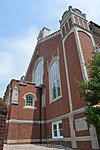
65
Washington County Courthouse
July 25, 1977 (#77000660 ) Public Sq., Main at Lincoln Park Rd. 37°41′06″N 85°13′16″W / 37.685°N 85.221111°W / 37.685; -85.221111 (Washington County Courthouse ) Springfield Two-story brick courthouse built in 1815, with an octagonal cupola added in 1840. Included in .
66
Upload image February 10, 1989 (#88003410 ) Hardesty Rd. 37°48′00″N 85°12′41″W / 37.8°N 85.211389°W / 37.8; -85.211389 (Thomas H. Williams House ) Springfield
67
February 10, 1989 (#88003432 ) Kentucky Route 53 37°48′30″N 85°07′29″W / 37.808333°N 85.124722°W / 37.808333; -85.124722 (Willisburg Central Bank and Post Office ) Willisburg
68
Willisburg Historic District
January 22, 2014 (#12001204 ) Along Kentucky Routes 53 and 433 37°48′27″N 85°07′25″W / 37.807631°N 85.123746°W / 37.807631; -85.123746 (Willisburg Historic District ) Willisburg