National Register of Historic Places listings in Boyle County, Kentucky

Location of Boyle County in Kentucky
This is a list of the National Register of Historic Places listings in Boyle County, Kentucky.
This is intended to be a complete list of the properties and districts on the National Register of Historic Places in Boyle County, Kentucky, United States. The locations of National Register properties and districts for which the latitude and longitude coordinates are included below, may be seen in a map.[1]
There are 98 properties and districts listed on the National Register in the county, including 3 that are National Historic Landmarks.
This National Park Service list is complete through NPS recent listings posted February 18, 2022.[2]
Current listings[]
| [3] | Name on the Register | Image | Date listed[4] | Location | City or town | Description |
|---|---|---|---|---|---|---|
| 1 | Aliceton Camp Meeting Ground | April 9, 1998 (#98000329) |
657 Ward's Branch Rd. 37°35′22″N 85°01′49″W / 37.589444°N 85.030278°W | Gravel Switch | ||
| 2 | June 23, 1983 (#83002578) |
Kentucky Route 34 37°39′51″N 84°43′33″W / 37.664167°N 84.725833°W | Bryantsville | |||
| 3 | June 26, 2019 (#100004121) |
204 E. Walnut St. 37°38′40″N 84°46′06″W / 37.6444°N 84.7683°W | Danville | |||
| 4 |  |
January 1, 1976 (#76000851) |
Northwest of Perryville on Old Mackville Rd. 37°39′52″N 84°58′14″W / 37.664444°N 84.970556°W | Perryville | ||
| 5 | May 28, 1999 (#97001367) |
Kentucky Route 34 37°35′50″N 84°53′43″W / 37.597222°N 84.895278°W | Parksville | |||
| 6 | Boyle County Courthouse | 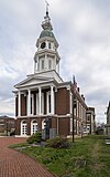 |
April 11, 1973 (#73000790) |
Main and 4th Sts. 37°38′47″N 84°46′24″W / 37.646389°N 84.773333°W | Danville | |
| 7 | November 25, 1980 (#80001485) |
North of Danville on Bellows Mill Rd. 37°42′58″N 84°47′37″W / 37.716111°N 84.793611°W | Danville | Demolished in 2017.[5] | ||
| 8 | November 19, 1997 (#97001356) |
Kentucky Route 34, 1 mile (1.6 km) east of Danville 37°39′52″N 84°43′38″W / 37.664444°N 84.727222°W | Danville | |||
| 9 | November 21, 1997 (#97001359) |
0.2 miles (0.32 km) east of Buster Rd., 0.1 miles (0.16 km) south of Mercer County line 37°42′53″N 84°46′42″W / 37.714722°N 84.778333°W | Danville | |||
| 10 | June 23, 1983 (#83002579) |
Off U.S. Route 150 37°38′07″N 84°51′13″W / 37.635278°N 84.853611°W | Danville | |||
| 11 | May 28, 1999 (#97001361) |
0.2 miles (0.32 km) north of Kentucky Route 34, 0.6 miles (0.97 km) west of 37°37′47″N 84°48′38″W / 37.629722°N 84.810556°W | Danville | |||
| 12 | May 28, 1999 (#97001368) |
Irvine Rd., 0.4 miles (0.64 km) north of Kentucky Route 34 37°37′13″N 84°51′04″W / 37.620278°N 84.851111°W | Danville | |||
| 13 | November 17, 1977 (#77000602) |
3 miles (4.8 km) northwest of Danville off U.S. Route 127 37°40′13″N 84°47′59″W / 37.670278°N 84.799722°W | Danville | |||
| 14 | Carnegie Library |  |
March 28, 1986 (#86000645) |
Centre College campus 37°38′40″N 84°46′45″W / 37.644444°N 84.779167°W | Danville | |
| 15 | April 9, 1998 (#98000327) |
Crossing of Norfolk Southern railroad line and Mocks Branch 37°41′54″N 84°46′48″W / 37.698333°N 84.78°W | Danville | |||
| 16 | Clifton Baptist Church Complex | February 12, 1998 (#98000085) |
Clifton Rd., 1 mile (1.6 km) northeast of Kentucky Route 52 37°38′49″N 84°41′30″W / 37.646944°N 84.691667°W | Clifton | ||
| 17 | November 21, 1997 (#97001375) |
Clifton Rd., 0.6 miles (0.97 km) north of Kentucky Route 52 37°38′31″N 84°41′44″W / 37.641944°N 84.695556°W | Clifton | |||
| 18 | Confederate Monument in Danville |  |
July 17, 1997 (#97000720) |
Junction of Main and College Sts. 37°38′44″N 84°46′42″W / 37.645556°N 84.778333°W | Danville | |
| 19 | Confederate Monument in Perryville |  |
July 17, 1997 (#97000722) |
Perryville State Historic Site, 2.5 miles (4.0 km) northwest of Perryville 37°40′29″N 84°58′17″W / 37.674722°N 84.971389°W | Perryville | |
| 20 | Constitution Square Historic District | 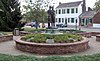 |
April 2, 1976 (#76000847) |
Bounded by Main and Walnut Sts., 1st and 2nd Sts. 37°38′42″N 84��46′14″W / 37.645°N 84.770556°W | Danville | |
| 21 |  |
January 1, 1976 (#76000852) |
Northeast of Perryville off U.S. Route 68 37°39′45″N 84°56′24″W / 37.6625°N 84.94°W | Perryville | ||
| 22 |  |
June 23, 1983 (#83002581) |
Off Kentucky Route 52 37°38′21″N 84°44′46″W / 37.639167°N 84.746111°W | Bryantsville | ||
| 23 | 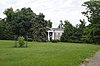 |
June 23, 1983 (#83002580) |
Stanford Rd. and Alta Ave. 37°38′30″N 84°45′39″W / 37.641667°N 84.760833°W | Danville | ||
| 24 |  |
November 21, 1997 (#97001374) |
678 and 690 Shelby St. 37°35′07″N 84°47′33″W / 37.585278°N 84.7925°W | Junction City | ||
| 25 |  |
March 31, 1986 (#86000643) |
W. Main between N. 5th and N. 1st, and area bounded by S. 3rd, W. Walnut, and S. 4th 37°38′43″N 84°46′19″W / 37.645278°N 84.771944°W | Danville | ||
| 26 | Danville National Cemetery |  |
May 29, 1998 (#98000591) |
277 N. 1st St. 37°39′13″N 84°46′15″W / 37.653611°N 84.770833°W | Danville | |
| 27 | July 31, 1998 (#98000941) |
Junction of Spears Ln. and Kentucky Route 33 east of Shakertown Rd. 37°40′44″N 84°45′15″W / 37.678889°N 84.754167°W | Danville | |||
| 28 | East Main Street Historic District |  |
March 31, 1986 (#86000640) |
419-619 E. Main St. 37°38′42″N 84°45′42″W / 37.645°N 84.761667°W | Danville | built between 1890 and 1930 |
| 29 | First Christian Church |  |
April 9, 1998 (#98000331) |
Junction of Shelby and Cemetery Sts. 37°35′05″N 84°47′29″W / 37.584722°N 84.791389°W | Junction City | |
| 30 | First Presbyterian Church |  |
March 31, 1986 (#86000638) |
W. Main between N. 5th and N. 6th Sts. 37°38′44″N 84°46′38″W / 37.645556°N 84.777222°W | Danville | |
| 31 | October 16, 1989 (#89001712) |
Kentucky Route 34, 3 miles (4.8 km) northeast of Danville 37°40′09″N 84°43′47″W / 37.669167°N 84.729722°W | Danville | |||
| 32 |  |
February 12, 1998 (#98000086) |
Junction of Kentucky Route 37 and Curtis Rd. 37°33′06″N 84°59′06″W / 37.551667°N 84.985°W | Gravel Switch | ||
| 33 | November 19, 1997 (#97001370) |
, 0.4 miles (0.64 km) south of its bypass 37°37′01″N 84°43′44″W / 37.616944°N 84.728889°W | Danville | |||
| 34 |  |
January 8, 2014 (#13001047) |
470 Stanford Rd. 37°38′28″N 84°45′50″W / 37.641111°N 84.763889°W | Danville | ||
| 35 |  |
November 19, 1997 (#97001355) |
2570 Lancaster Rd. 37°37′47″N 84°43′48″W / 37.629722°N 84.73°W | Danville | ||
| 36 | November 21, 1997 (#97001362) |
8803 Kentucky Route 34 37°37′14″N 84°49′36″W / 37.620556°N 84.826667°W | Danville | |||
| 37 | May 28, 1999 (#98000336) |
North of the junction of Kentucky Routes 37 and 243 37°33′12″N 85°01′24″W / 37.553333°N 85.023333°W | Gravel Switch | |||
| 38 | July 31, 1998 (#98000931) |
0.3 miles (0.48 km) northwest of , 0.6 miles (0.97 km) south of Whites Rd. 37°40′37″N 84°57′41″W / 37.676944°N 84.961389°W | Perryville | |||
| 39 | October 21, 1976 (#76000848) |
5 miles (8.0 km) west of Danville on Salt River Rd. 37°40′21″N 84°52′21″W / 37.6725°N 84.8725°W | Danville | |||
| 40 | June 23, 1983 (#83002582) |
U.S. Route 150 37°40′07″N 84°52′09″W / 37.668611°N 84.869167°W | Danville | |||
| 41 | November 14, 1978 (#78001304) |
5 miles (8.0 km) east of Danville off Kentucky Route 52 37°37′40″N 84°42′31″W / 37.6278°N 84.7086°W | Danville | |||
| 42 | December 21, 1998 (#98000942) |
Western side of U.S. Route 127, 3.25 miles (5.23 km) south of the county line 37°40′49″N 84°48′31″W / 37.6803°N 84.8086°W | Danville | |||
| 43 |  |
March 31, 1986 (#86000636) |
420 Lexington Ave. 37°39′05″N 84°45′32″W / 37.6514°N 84.7589°W | Danville | ||
| 44 | November 19, 1997 (#97001353) |
Kentucky Route 52, 0.2 miles (0.32 km) west of its junction with Kentucky Route 590 37°38′07″N 84°41′11″W / 37.6353°N 84.6864°W | Danville | |||
| 45 | Jacobs Hall, Kentucky School for the Deaf | 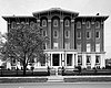 |
October 15, 1966 (#66000354) |
S. 3rd St. 37°38′29″N 84°46′18″W / 37.6414°N 84.7717°W | Danville | |
| 46 | 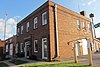 |
April 9, 1998 (#98000328) |
Junction of Shelby and Lucas Sts. 37°35′14″N 84°47′49″W / 37.5872°N 84.7969°W | Junction City | built in 1939 | |
| 47 | June 23, 1983 (#83002583) |
U.S. Route 150 37°38′59″N 84°51′51″W / 37.6497°N 84.8642°W | Danville | |||
| 48 | May 28, 1999 (#97001372) |
3910 Hustonville Rd. 37°35′22″N 84°46′27″W / 37.5894°N 84.7742°W | Danville | |||
| 49 |  |
January 12, 1987 (#87000198) |
W. and E. Lexington between N. 5th and Old Wilderness Rd. and area bounded by N. Larrimore, W. Broadway, and N. 5th 37°38′55″N 84°46′15″W / 37.6486°N 84.7708°W | Danville | ||
| 50 | June 16, 1987 (#87001241) |
Both sides of Maple Ave. between W. Main and High 37°38′59″N 84°46′57″W / 37.6497°N 84.7825°W | Danville | |||
| 51 | June 23, 1983 (#83002584) |
Off Kentucky Route 34 37°37′14″N 84°48′29″W / 37.6206°N 84.8081°W | Junction City | |||
| 52 | March 16, 2021 (#100006268) |
350 Harberson Ln. 37°36′04″N 84°53′58″W / 37.6010°N 84.8995°W | Danville | |||
| 53 | November 27, 1991 (#91001711) |
Off U.S. Route 127, 3 miles (4.8 km) north of Danville 37°41′55″N 84°48′42″W / 37.6986°N 84.8117°W | Danville | |||
| 54 |  |
March 7, 1973 (#73000791) |
304 S. 4th St. 37°38′36″N 84°46′26″W / 37.6433°N 84.7739°W | Danville | ||
| 55 | Dr. Ephraim McDowell House |  |
October 15, 1966 (#66000355) |
125-127 S. 2nd St. 37°38′43″N 84°46′15″W / 37.6453°N 84.7708°W | Danville | |
| 56 | November 21, 1997 (#97001360) |
U.S. Route 127, 0.2 miles (0.32 km) south of 37°36′54″N 84°46′37″W / 37.615°N 84.7769°W | Danville | |||
| 57 | March 7, 2019 (#100003476) |
Wilderness Rd. between E. Broadway and Fitzpatrick St. 37°38′51″N 84°45′56″W / 37.6474°N 84.7656°W | Danville | |||
| 58 | April 3, 1986 (#86000631) |
U.S. Route 127 37°41′19″N 84°47′43″W / 37.6886°N 84.7953°W | Danville | |||
| 59 | November 19, 1997 (#97001349) |
Kentucky Route 34, 0.4 miles (0.64 km) from its junction with 37°36′04″N 84°56′42″W / 37.6011°N 84.945°W | Mitchellsburg | |||
| 60 | April 9, 1998 (#98000332) |
L&N railroad grade over Buck Creek 37°36′05″N 84°57′10″W / 37.6014°N 84.9528°W | Mitchellsburg | |||
| 61 | June 23, 1983 (#83002585) |
Off Kentucky Route 33 37°41′44″N 84°45′06″W / 37.6956°N 84.7517°W | Danville | |||
| 62 | December 29, 1994 (#94001506) |
3901 Harrodsburg Rd. 37°41′29″N 84°48′08″W / 37.6914°N 84.8022°W | Danville | |||
| 63 | November 21, 1997 (#97001369) |
Junction of Kentucky Routes 34 and 37°36′20″N 84°52′54″W / 37.605556°N 84.881667°W | Parksville | |||
| 64 | Old Centre, Centre College | 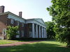 |
August 25, 1972 (#72000529) |
W. Walnut St., Centre College campus 37°38′44″N 84°46′54″W / 37.645556°N 84.781667°W | Danville | |
| 65 | November 19, 1997 (#97001364) |
2907 Perryville Rd. 37°39′20″N 84°49′12″W / 37.655556°N 84.82°W | Danville | |||
| 66 |  |
February 12, 1998 (#98000094) |
0.1 miles (0.16 km) west of Kentucky Route 243, on Boyle-Casey County line 37°32′59″N 85°01′41″W / 37.549722°N 85.028056°W | Gravel Switch | ||
| 67 | Perryville Battlefield | 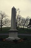 |
October 15, 1966 (#66000356) |
West of Perryville on U.S. Route 150 37°40′35″N 84°58′04″W / 37.676484°N 84.967711°W | Perryville | |
| 68 | Perryville Historic District |  |
October 25, 1973 (#73000792) |
Roughly bounded by Sheridan Ave., Wood, Jefferson, and 5th Sts. 37°38′58″N 84°57′04″W / 37.649444°N 84.951111°W | Perryville | |
| 69 | November 15, 1984 (#84000357) |
Lexington Rd. 37°40′19″N 84°45′05″W / 37.671944°N 84.751389°W | Danville | |||
| 70 | November 19, 1997 (#97001351) |
Curtis Rd. at the Rolling Fork River 37°32′37″N 84°58′57″W / 37.543611°N 84.9825°W | Gravel Switch | |||
| 71 | March 30, 1995 (#95000301) |
0.3 miles (0.48 km) south of Faulconer Rd., on S. Buster Pike 37°42′08″N 84°46′49″W / 37.702222°N 84.780278°W | Danville | |||
| 72 | April 9, 1998 (#98000333) |
, 1.5 miles (2.4 km) north of Kentucky Route 34 37°37′04″N 84°57′16″W / 37.617778°N 84.954444°W | Mitchellsburg | |||
| 73 |  |
November 21, 1997 (#97001371) |
Junction of Shelby St. and White Oak Rd. 37°35′15″N 84°47′51″W / 37.5875°N 84.7975°W | Junction City | ||
| 74 | March 13, 1986 (#86000369) |
U.S. Route 127 37°40′54″N 84°47′18″W / 37.681667°N 84.788333°W | Danville | |||
| 75 |  |
January 23, 2013 (#12001198) |
124 E. Walnut St. 37°38′39″N 84°46′08″W / 37.644167°N 84.768889°W | Danville | ||
| 76 |  |
January 28, 1994 (#93001582) |
125-162 St. Mildred's Ct. and 797-852 W. Lexington Ave. 37°38′51″N 84°46′49″W / 37.647500°N 84.780278°W | Danville | ||
| 77 | November 19, 1997 (#97001350) |
Along Salt River Rd. 37°39′38″N 84°51′49″W / 37.660556°N 84.863611°W | Danville | |||
| 78 |  |
January 23, 2013 (#12001197) |
228 S. 2nd St. 37°38′38″N 84°46′15″W / 37.643750°N 84.770833°W | Danville | ||
| 79 | November 21, 1997 (#97001358) |
0.1 miles (0.16 km) west of Kentucky Route 33, 0.6 miles (0.97 km) south of Spears Ln. 37°40′22″N 84°45′59″W / 37.672778°N 84.766389°W | Danville | |||
| 80 | January 27, 1983 (#83002586) |
South of Danville on U.S. Route 150 37°36′47″N 84°43′14″W / 37.613056°N 84.720556°W | Danville | |||
| 81 | April 9, 1998 (#98000335) |
Junction of Cash Rd. and Old Mitchellsburg Rd. 37°35′51″N 84°54′38″W / 37.5975°N 84.910556°W | Parksville | |||
| 82 | June 23, 1983 (#83002587) |
Kentucky Route 34 37°40′07″N 84°43′19″W / 37.668611°N 84.721944°W | Bryantsville | |||
| 83 | April 9, 1998 (#98000334) |
Junction of Tank Pond Rd. and Kentucky Route 34 37°35′44″N 84°54′39″W / 37.595556°N 84.910833°W | Mitchellsburg | |||
| 84 |  |
August 31, 2010 (#09001305) |
North and south sides of Terrace Ct., west of Old Wilderness Rd. 37°38′46″N 84°46′01″W / 37.646078°N 84.766949°W | Danville | ||
| 85 | June 23, 1983 (#83002588) |
Off U.S. Route 68 37°40′55″N 84°55′02″W / 37.681944°N 84.917222°W | Perryville | |||
| 86 |  |
July 20, 1977 (#77000603) |
Northwest of Danville off U.S. Route 127, 525 Maple Ave., and south of Danville off Kentucky Route 35 37°39′16″N 84°47′03″W / 37.654583°N 84.784167°W | Danville | ||
| 87 |  |
March 26, 1976 (#76000849) |
229, 243, 251, and 305 N. 3rd St. 37°38′55″N 84°46′21″W / 37.648611°N 84.7725°W | Danville | ||
| 88 | Trinity Episcopal Church | 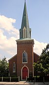 |
September 15, 1977 (#77000604) |
320 W. Main St. 37°38′43″N 84°46′24″W / 37.645278°N 84.773333°W | Danville | |
| 89 | Union Monument in Perryville | 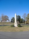 |
July 17, 1997 (#97000723) |
Perryville Battlefield State Historic Site, 2.5 miles (4.0 km) northwest of Perryville 37°40′30″N 84°58′17″W / 37.675°N 84.971389°W | Perryville | |
| 90 | Unknown Confederate Dead Monument in Perryville |  |
July 17, 1997 (#97000721) |
Address Restricted | Perryville | |
| 91 | November 19, 1997 (#97001376) |
Kentucky Route 52 in Atoka 37°38′54″N 84°51′40″W / 37.648333°N 84.861111°W | Danville | |||
| 92 | August 14, 1998 (#97001373) |
378 Salt River Rd. 37°41′26″N 84°52′50″W / 37.690556°N 84.880556°W | Danville | |||
| 93 | November 19, 1997 (#97001357) |
Kentucky Route 34, 0.4 miles (0.64 km) south of the Mercer County line 37°42′31″N 84°45′46″W / 37.708611°N 84.762778°W | Danville | |||
| 94 |  |
March 31, 1986 (#86000634) |
Intersection of Harding and W. Walnut Sts. 37°38′42″N 84°47′03″W / 37.645000°N 84.784167°W | Danville | ||
| 95 | Waveland |  |
May 6, 1976 (#76000850) |
0.5 miles (0.80 km) south of Danville 37°37′28″N 84°46′06″W / 37.624444°N 84.768333°W | Danville | |
| 96 |  |
November 21, 1997 (#97001363) |
3750 Lebanon Rd. 37°37′15″N 84°48′49″W / 37.620833°N 84.813611°W | Danville | ||
| 97 | November 21, 1997 (#97001365) |
0.3 miles (0.48 km) west of Bluegrass Rd., 0.6 miles (0.97 km) north of Gentry Ln. 37°41′01″N 84°50′06″W / 37.683611°N 84.835°W | Danville | |||
| 98 | November 19, 1997 (#97001352) |
Kentucky Route 590, 0.7 miles (1.1 km) south of its junction with Kentucky Route 52 37°37′31″N 84°41′08″W / 37.625278°N 84.685556°W | Danville |

See also[]
| Wikimedia Commons has media related to National Register of Historic Places in Boyle County, Kentucky. |
- List of National Historic Landmarks in Kentucky
- National Register of Historic Places listings in Kentucky
References[]
- ^ The latitude and longitude information provided in this table was derived originally from the National Register Information System, which has been found to be fairly accurate for about 99% of listings. Some locations in this table may have been corrected to current GPS standards.
- ^ National Park Service, United States Department of the Interior, "National Register of Historic Places: Weekly List Actions", retrieved February 18, 2022.
- ^ Numbers represent an alphabetical ordering by significant words. Various colorings, defined here, differentiate National Historic Landmarks and historic districts from other NRHP buildings, structures, sites or objects.
- ^ The eight-digit number below each date is the number assigned to each location in the National Register Information System database, which can be viewed by clicking the number.
- ^ https://www.kentucky.com/news/state/article159317574.html[bare URL]
Municipalities and communities of Boyle County, Kentucky, United States | ||
|---|---|---|
County seat: Danville | ||
| Cities |
|  |
| Unincorporated communities | ||
| ||
Categories:
- Lists of National Register of Historic Places in Kentucky by county
- National Register of Historic Places in Boyle County, Kentucky
- Buildings and structures in Boyle County, Kentucky