National Register of Historic Places listings in Ohio County, Kentucky

Location of Ohio County in Kentucky
This is a list of the National Register of Historic Places listings in Ohio County, Kentucky.
This is intended to be a complete list of the properties and districts on the National Register of Historic Places in Ohio County, Kentucky, United States. The locations of National Register properties and districts for which the latitude and longitude coordinates are included below, may be seen in a map.[1]
There are 19 properties and districts listed on the National Register in the county, of which 1 is a National Historic Landmark and 6 are part of another National Historic Landmark spread across multiple counties.
This National Park Service list is complete through NPS recent listings posted February 18, 2022.[2]
Current listings[]
| [3] | Name on the Register | Image | Date listed[4] | Location | City or town | Description |
|---|---|---|---|---|---|---|
| 1 | April 1, 1986 (#86000655) |
Foot of Kirtley-River Rd. at the Green River above Livermore[5] 37°26′12″N 87°06′08″W / 37.436667°N 87.102222°W | Kirtley | Part of the Green River Shell Middens Archeological District National Historic Landmark[6]: 30 | ||
| 2 | April 1, 1986 (#86000669) |
Across the Green River from South Carrollton[5] 37°20′12″N 87°07′48″W / 37.336667°N 87.130000°W | Central City | Part of the Green River Shell Middens Archeological District National Historic Landmark[6]: 29 | ||
| 3 | April 1, 1986 (#86000656) |
Northern side of the Green River opposite Rochester[7] 37°12′51″N 86°53′52″W / 37.214167°N 86.897778°W | Rochester | Part of the Green River Shell Middens Archeological District National Historic Landmark[6]: 27 | ||
| 4 | Ceralvo Masonic Hall and School | October 15, 2015 (#15000655) |
942 Ceralvo Rd. 37°21′59″N 87°01′52″W / 37.3663°N 87.031°W | Centertown | ||
| 5 | April 1, 1986 (#86000665) |
Right bank of the Green River, 3 miles (4.8 km) above the Paradise Fossil Plant[8] 37°14′25″N 86°56′29″W / 37.240278°N 86.941389°W | Knightsburg | Part of the Green River Shell Middens Archeological District National Historic Landmark[6]: 25 | ||
| 6 | Downtown Hartford Historic District | 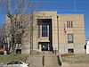 |
December 12, 1988 (#88002760) |
Roughly the 100 and 200 blocks of Main St. and Courthouse Sq. 37°27′04″N 86°54′32″W / 37.451111°N 86.908889°W | Hartford | |
| 7 | Dundee Masonic Lodge No. 733 |  |
March 25, 2008 (#08000213) |
11640 Kentucky Route 69 N. 37°33′25″N 86°46′22″W / 37.556944°N 86.772778°W | Dundee | |
| 8 |  |
June 19, 1973 (#73000826) |
224 E. Center St. 37°27′07″N 86°54′23″W / 37.451944°N 86.906389°W | Hartford | ||
| 9 | Samuel E. Hill House |  |
May 27, 1980 (#80001663) |
519 E. Union St. 37°27′28″N 86°54′16″W / 37.457639°N 86.904444°W | Hartford | |
| 10 | Indian Knoll | October 15, 1966 (#66000362) |
Right bank of the Green River opposite the Paradise Fossil Plant at Paradise[9] 37°15′50″N 86°58′24″W / 37.263889°N 86.973333°W | Paradise | ||
| 11 | April 1, 1986 (#86000666) |
Address Restricted | Rockport | |||
| 12 | April 1, 1986 (#86000667) |
Jimtown Hill, 2 miles (3.2 km) above Livermore[5] 37°28′00″N 87°06′32″W / 37.466667°N 87.108889°W | Kirtley | Part of the Green River Shell Middens Archeological District National Historic Landmark[6]: 28 | ||
| 13 | Louisville, Henderson, and St. Louis Railroad Depot | 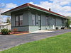 |
July 26, 1991 (#91000923) |
Southeastern side of Walnut St., 200 feet north of its junction with Kentucky Route 54 37°38′11″N 86°43′01″W / 37.636389°N 86.716944°W | Fordsville | |
| 14 | Bill Monroe Farm | 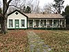 |
July 18, 2003 (#03000648) |
Approximately 2 miles west of the junction of U.S. Route 62 and 37°25′58″N 86°45′53″W / 37.432778°N 86.764722°W | Rosine | |
| 15 | Old Town Historic District | 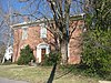 |
November 15, 1988 (#88002535) |
Roughly bounded by E. Union, Clay, E. Washington and Liberty Sts. 37°27′08″N 86°54′24″W / 37.452222°N 86.906667°W | Hartford | |
| 16 | Pendleton House |  |
May 17, 1973 (#73000827) |
403 E. Union St. 37°27′17″N 86°54′21″W / 37.454722°N 86.905833°W | Hartford | |
| 17 | Rosine General Store and Barn |  |
August 1, 2003 (#03000708) |
8205 Blue Moon of Kentucky Highway/ U.S. Route 62 37°27′03″N 86°44′28″W / 37.450834°N 86.741106°W | Rosine | |
| 18 | April 1, 1986 (#86000668) |
Right bank of the Green River at Smallhous[10] 37°22′49��N 87°05′33″W / 37.380278°N 87.092500°W | Smallhous | Part of the Green River Shell Middens Archeological District National Historic Landmark[6]: 26 | ||
| 19 | March 15, 1984 (#84001890) |
Address Restricted | Hartford |

See also[]
| Wikimedia Commons has media related to National Register of Historic Places in Ohio County, Kentucky. |
- List of National Historic Landmarks in Kentucky
- National Register of Historic Places listings in Kentucky
References[]
- ^ The latitude and longitude information provided in this table was derived originally from the National Register Information System, which has been found to be fairly accurate for about 99% of listings. Some locations in this table may have been corrected to current GPS standards.
- ^ National Park Service, United States Department of the Interior, "National Register of Historic Places: Weekly List Actions", retrieved February 18, 2022.
- ^ Numbers represent an alphabetical ordering by significant words. Various colorings, defined here, differentiate National Historic Landmarks and historic districts from other NRHP buildings, structures, sites or objects.
- ^ The eight-digit number below each date is the number assigned to each location in the National Register Information System database, which can be viewed by clicking the number.
- ^ a b c Claassen, Cheryl. Feasting with Shellfish in the Southern Ohio Valley: Archaic Sacred Sites and Rituals. Knoxville: U of Tennessee P, 2010, 41.
- ^ a b c d e f National Historic Landmark Nomination: Green River Shell Middens. National Park Service: 1994-05-05.
- ^ Emerson, Thomas E. Archaic Societies: Diversity and Complexity Across the Midcontinent. Albany: SUNY Press, 2009, 655.
- ^ Moore, Christopher R. Production, Exchange, and Social Interaction in the Green River Region of Western Kentucky: A Multiscalar Approach to the Analysis of Two Shell Midden Sites. Diss. University of Kentucky, 2011, 163.
- ^ Funkhouser, W.D., and W.S. Webb. "Archaeological Survey of Kentucky: Butler County". University of Kentucky Reports in Anthropology 7.5 (1950): 324.
- ^ Moore, Clarence B. "Some Aboriginal Sites on Green River, Kentucky". Journal of the Philadelphia Academy of Natural Sciences 16 (1916): 431-487: 443.
Municipalities and communities of Ohio County, Kentucky, United States | ||
|---|---|---|
County seat: Hartford | ||
| Cities |
|  |
| CDPs |
| |
| Other unincorporated communities | ||
| Footnotes | ‡This populated place also has portions in an adjacent county or counties | |
| ||
Categories:
- Lists of National Register of Historic Places in Kentucky by county
- National Register of Historic Places in Ohio County, Kentucky