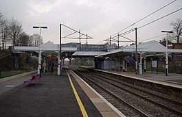
New Southgate railway station
| New Southgate | |
|---|---|
 | |
 New Southgate Location of New Southgate in Greater London | |
| Location | New Southgate |
| Local authority | London Borough of Enfield |
| Managed by | Great Northern |
| Station code | NSG |
| DfT category | E |
| Number of platforms | 4 |
| Fare zone | 4 |
| National Rail annual entry and exit | |
| 2016–17 | |
| 2017–18 | |
| 2018–19 | |
| 2019–20 | |
| 2020–21 | |
| Other information | |
| External links | |
| WGS84 | 51°36′51″N 0°08′36″W / 51.6142°N 0.1432°WCoordinates: 51°36′51″N 0°08′36″W / 51.6142°N 0.1432°W |

New Southgate railway station is on the boundary of the London Borough of Barnet and the London Borough of Enfield in north London, in Travelcard Zone 4. It is 6 miles 35 chains (10.4 km) down the line from London King's Cross.[2]
The station, and all trains serving it, have been operated by Great Northern since 14 September 2014.
Location[]
The station is administered by the London Borough of Enfield,[3] although the boundary with the London Borough of Barnet runs through the station, rather than along one side. The station has exits into both boroughs.[4]
History[]
Building of the station[]

The station opened by order of the Middlesex Justices (see Middlesex Guildhall),[5] on 7 August 1850 as Colney Hatch & Southgate station or Colney Hatch station[5][6][page needed][7] by the Great Northern Railway (GNR). The Justices insisted on trains stopping daily for the benefit of the Second Middlesex County Asylum opened that year at Colney Hatch, which became Friern Hospital and closed in 1993. The original booking office, which sat on a bridge across the railway lines, burned down in 1976 and was replaced by a portakabin.[8]
Service patterns[]
The station was built next to the asylum, with a siding which connected by a tramway to the stores depot in the grounds. There was one train hourly to Hatfield in the north and to Hornsey and King's Cross in the south in 1860, when the journey to King's Cross took 18 minutes. Trains, as before, ran hourly in 1975.[5]
Renamings[]
The name of the station has changed five times: to Southgate and Colney Hatch on 1 February 1855; to New Southgate and Colney Hatch on 1 October 1876; to New Southgate for Colney Hatch on 1 March 1883; to New Southgate and Friern Barnet on 1 May 1923; and finally to New Southgate on 18 March 1971,[9][6][page needed]
Operators[]
The GNR came under the London and North Eastern Railway (LNER) after "Grouping" in 1923, before British Railways took over upon nationalisation in 1948. WAGN (an acronym of West Anglia, Great Northern) operated the service from 1997 to 2006.
Ticketing[]
In autumn 2008, a self-service ticket machine widening payment methods to accept cash and debit/credit cards, was installed at the eastern street-level entrance. An older PERTIS machine remains in situ.[clarification needed]
Services[]
The service to Moorgate is operated using class 717 EMUs.
The typical off-peak service is three trains an hour to Moorgate, reduced to two after 7:00 pm. Night and weekend trains run every 30 minutes. There are three trains an hour to Welwyn Garden City, reduced to two in the late evenings and at weekends.[10] A few additional Thameslink trains to and from Kings Cross call in the weekday business peaks (into London in the morning, returning in the evening).
| Preceding station | Following station | |||
|---|---|---|---|---|
| Great Northern | ||||
| Future Development | ||||
| Preceding station | Following station | |||
| Crossrail Crossrail 2 | Terminus | |||
Connections[]
London Buses routes 221, 232, 382 and night route N91 serve the station.[11]
References[]
- ^ a b c d e "Estimates of station usage". Rail statistics. Office of Rail Regulation. Please note: Some methodology may vary year on year.
- ^ Padgett, David (October 2016) [1988]. Brailsford, Martyn (ed.). Railway Track Diagrams 2: Eastern (4th ed.). Frome: Trackmaps. map 14B. ISBN 978-0-9549866-8-1.
- ^ "New Southgate Railway Station, Enfield - area information, map, walks and more". Ordnance Survey Get Outside. Ordnance Survey. Retrieved 18 February 2021.
- ^ "New Southgate Railway Station, Enfield - area information, map, walks and more". Ordnance Survey Get Outside. Ordnance Survey. Retrieved 18 February 2021.
- ^ a b c Baggs, A.P.; Bolton, Diane K.; Hicks, M.A.; Pugh, R.B. (1980). "Friern Barnet: Introduction". In Baker, T.F.T.; Elrington, C.R. (eds.). A History of the County of Middlesex: Volume 6. London. pp. 6–15.
- ^ a b Connor, J.E.; Halford, B. Forgotten Stations of Greater London.[full citation needed]
- ^ Borley, H.V. Chronology Of London Railways.[full citation needed]
- ^ Barratt, Colin. "New Southgate Station Fire". Friern Barnet Photo Archive. Retrieved 25 May 2019.
- ^ Butt, R.V.J. (1995). The Directory of Railway Stations. Yeovil: Patrick Stephens Ltd. pp. 66, 171, 215. ISBN 1-85260-508-1. R508.
- ^ Table 24 National Rail timetable, May 2016
- ^ "Buses from Arnos Grove and New Southgate" (PDF). TfL. 13 November 2017. Retrieved 22 August 2021.
External links[]
| Wikimedia Commons has media related to New Southgate railway station. |
- Train times and station information for New Southgate railway station from National Rail
Transport in London | |||||||||||
|---|---|---|---|---|---|---|---|---|---|---|---|
| Companies and organisations |
| ||||||||||
| Airports |
| ||||||||||
| Major stations |
| ||||||||||
| Roads |
| ||||||||||
| Ticketing |
| ||||||||||
| Other | |||||||||||
| Former BR sectors | |||||||||||
| |||||||||||
- Rail transport stations in London fare zone 4
- DfT Category E stations
- Railway stations in the London Borough of Barnet
- Railway stations in the London Borough of Enfield
- Railway stations in Great Britain opened in 1850
- Former Great Northern Railway stations
- Thameslink railway stations