Oakleigh railway station
Oakleigh | |||||||||||||||||||||||||||||||||||||||||||||||||||||||||||||||
|---|---|---|---|---|---|---|---|---|---|---|---|---|---|---|---|---|---|---|---|---|---|---|---|---|---|---|---|---|---|---|---|---|---|---|---|---|---|---|---|---|---|---|---|---|---|---|---|---|---|---|---|---|---|---|---|---|---|---|---|---|---|---|---|
| PTV commuter rail station | |||||||||||||||||||||||||||||||||||||||||||||||||||||||||||||||
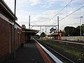
 Eastbound view from Platform 1 (formerly Platform 2) in January 2021 | |||||||||||||||||||||||||||||||||||||||||||||||||||||||||||||||
| Location | Haughton Road, Oakleigh, Victoria 3166 City of Monash Australia | ||||||||||||||||||||||||||||||||||||||||||||||||||||||||||||||
| Coordinates | 37°54′02″S 145°05′18″E / 37.9005°S 145.0883°ECoordinates: 37°54′02″S 145°05′18″E / 37.9005°S 145.0883°E | ||||||||||||||||||||||||||||||||||||||||||||||||||||||||||||||
| Owned by | VicTrack | ||||||||||||||||||||||||||||||||||||||||||||||||||||||||||||||
| Operated by | Metro Trains | ||||||||||||||||||||||||||||||||||||||||||||||||||||||||||||||
| Line(s) | Pakenham Cranbourne | ||||||||||||||||||||||||||||||||||||||||||||||||||||||||||||||
| Distance | 16.59 kilometres from Southern Cross | ||||||||||||||||||||||||||||||||||||||||||||||||||||||||||||||
| Platforms | 2 (excluding one removed) | ||||||||||||||||||||||||||||||||||||||||||||||||||||||||||||||
| Tracks | 2 (excluding one removed) | ||||||||||||||||||||||||||||||||||||||||||||||||||||||||||||||
| Train operators | Metro Trains | ||||||||||||||||||||||||||||||||||||||||||||||||||||||||||||||
| Connections | 13 bus routes | ||||||||||||||||||||||||||||||||||||||||||||||||||||||||||||||
| Construction | |||||||||||||||||||||||||||||||||||||||||||||||||||||||||||||||
| Structure type | At-grade | ||||||||||||||||||||||||||||||||||||||||||||||||||||||||||||||
| Parking | 400 spaces | ||||||||||||||||||||||||||||||||||||||||||||||||||||||||||||||
| Bicycle facilities | Yes | ||||||||||||||||||||||||||||||||||||||||||||||||||||||||||||||
| Disabled access | Yes | ||||||||||||||||||||||||||||||||||||||||||||||||||||||||||||||
| Other information | |||||||||||||||||||||||||||||||||||||||||||||||||||||||||||||||
| Status | Operational, Premium Station | ||||||||||||||||||||||||||||||||||||||||||||||||||||||||||||||
| Station code | OAK | ||||||||||||||||||||||||||||||||||||||||||||||||||||||||||||||
| Fare zone | Myki Zone 1/2 Overlap | ||||||||||||||||||||||||||||||||||||||||||||||||||||||||||||||
| Website | Public Transport Victoria | ||||||||||||||||||||||||||||||||||||||||||||||||||||||||||||||
| History | |||||||||||||||||||||||||||||||||||||||||||||||||||||||||||||||
| Opened | 8 October 1877 | ||||||||||||||||||||||||||||||||||||||||||||||||||||||||||||||
| Electrified | 1500 V DC overhead | ||||||||||||||||||||||||||||||||||||||||||||||||||||||||||||||
| Passengers | |||||||||||||||||||||||||||||||||||||||||||||||||||||||||||||||
| 2014-2015 | Not measured[1] | ||||||||||||||||||||||||||||||||||||||||||||||||||||||||||||||
| 2015-2016 | 2.07 million[1] | ||||||||||||||||||||||||||||||||||||||||||||||||||||||||||||||
| 2016-2017 | 2.06 million[1] | ||||||||||||||||||||||||||||||||||||||||||||||||||||||||||||||
| 2017-2018 | 1.81 million[1] | ||||||||||||||||||||||||||||||||||||||||||||||||||||||||||||||
| Services | |||||||||||||||||||||||||||||||||||||||||||||||||||||||||||||||
| |||||||||||||||||||||||||||||||||||||||||||||||||||||||||||||||
| |||||||||||||||||||||||||||||||||||||||||||||||||||||||||||||||
| |||||||||||||||||||||||||||||||||||||||||||||||||||||||||||||||

Oakleigh railway station is located on the Pakenham and Cranbourne lines in Victoria, Australia. It serves the south-eastern Melbourne suburb of Oakleigh, and it opened on 8 October 1877.[2]
Services on both railway lines will bypass Flinders Street and the City Loop, and will run to West Footscray and Sunbury stations, after the Metro Tunnel opens in 2025.
History[]
In 1877, a separate station was constructed at the city (Up) end of the railway line from Gippsland, with the current station site developed by 1879, when the line from South Yarra was completed. The station later served as the eastern end of both the Outer Circle and the Rosstown lines.
Since 1989, the station has featured over 40 plywood cut-outs on its walls and surrounding the station. These illustrate the life-stories of Oakleigh residents, who were aged between 15 and 70, when the murals were unveiled in September 1989. They underwent restoration in 2002.[3] About half of these have since been restored, and glue can still be seen on the walls of the station building where the remainder had previously been placed.
It was upgraded to a Premium Station on 12 December 1995.[4]
Signalling, interlocking and track layouts[]
The track was duplicated from Caulfield to Oakleigh in 1883, and to Dandenong in 1891.[2]
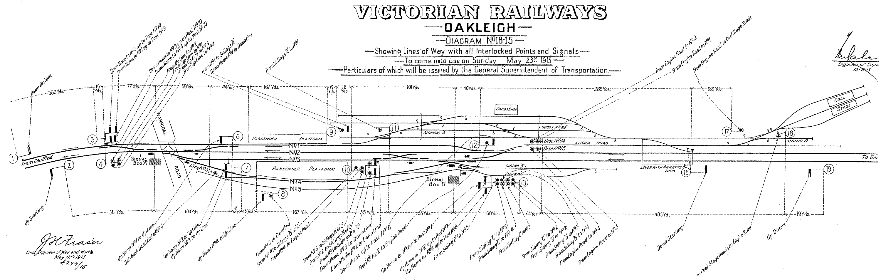
Circa 1910, the station featured two side platforms with an additional centre track.[5] By 1915, a new station building had been constructed to the same style as Box Hill, Essendon, Spotswood and Heidelberg, and a new platform provided on the south side, plus a fifth track for engines to run around their consists. By this time, the station was controlled by two signal boxes; "A" at the city end, controlling the Warrigal Road level crossing and interlocked gates, and "B", between the station and yard, controlling the latter.[5]
In March 1922, electrification was extended from Caulfield to Oakleigh, and this was extended to Dandenong during December of the same year.[2] Around the same time, the Hanover Street bridge was built across the Dandenong end of the goods yard, with alterations to the passenger sidings and the run-around loop south of the station was abolished.[6]
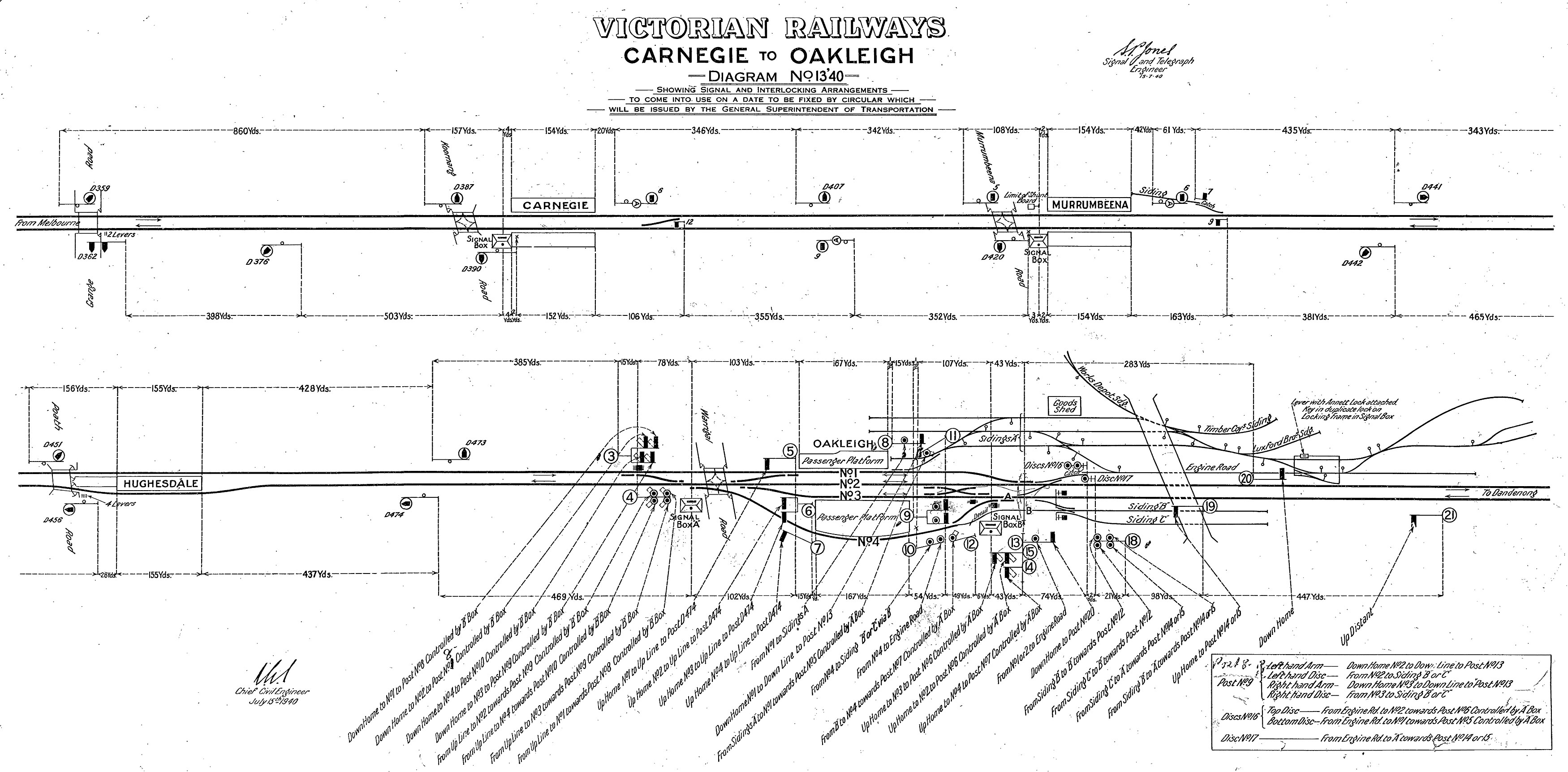
Three-position signalling was extended from Carnegie to the city end of Oakleigh (exclusive) in December 1940.[7][2] Extension of the signalling to Huntingdale and Clayton, in lieu of Winters Double Line Block safeworking, did not occur until 1970, in conjunction with the North Road (Huntingdale) grade separation project.
In 1968, the Warrigal Road level crossing was closed, and in conjunction with the demolition of shops, a new road overpass was provided. The original Warrigal Road surface was partially retained as a slip lane to serve a handful of shops along the western boundary. The road bridge piers were spaced to allow extension of the track from the southernmost platform in the citybound direction.
In 1975, the track layout was drastically simplified and both signal boxes were abolished and demolished, being replaced with a new, experimental route-setting power interlocking system, located in the middle of the southern station building.[8][9] In lieu of the older system with individual buttons for each signal and turnout or crossover, the panel used custom circuit boards and a button arrangement where the operator would select a route between any two signals, and that route would be requested, set and locked by the relay interlocking if available. A 1972 report by BITRE indicated that the project would cost $330,000, and save $26,000 per year in staffing costs, plus avoiding $10,000 expected in upcoming overhaul costs for the existing mechanical systems, with a total benefit/cost ratio over 40 years of 1.7:1 at 7% discount rates or 1.3 at 10% discount rates.[10][page needed] In practice, the new interlocking lasted 43 years.
The new signal panel included a "switch out" feature, allowing the station's signalling to operate automatically during periods of reduced traffic. To facilitate this, the island platform was used for most trains, with high-speed (40 mph) turnouts provided either end to avoid trains slowing down significantly for the diverging movements. In busier periods, the signal panel was switched in by station staff, to permit access to or from the goods yard, terminating moves from the city, or overtaking moves in either direction.
The goods yard was officially closed to traffic in May 1984 with the exception of briquette traffic, which was still being received. Way and Works wagon HD205, which had been parked at the city end of the through siding for years, was transferred to the Caulfield depot on Friday 22 June 1984.[11] By October that year, the briquette traffic had also shifted to Westall.[12] The overhead in siding "A" was removed by December of the same year, along with the points and the majority of the sidings.[12]
In March 1987, a guards' indicator light was provided for signal post 16, controlling citybound moves from Platform 1.[13]
As of April 1988, suburban timetables specified an overtaking move between outbound suburban and country trains, where the 16:53 and 17:36 departures from Flinders Street to Dandenong were each scheduled to wait 3 minutes at Oakleigh, for a Traralgon and Warragul service respectively.[14]
When the Cranbourne line was electrified in 1995, trains that had previously terminated at Oakleigh were extended and the passenger sidings fell into disuse. The extended goods siding that was along the north side fell out of use and was abolished around the same time, although the shell of the citybound dwarf signal at the Down end remained in situ until 2018. As a result, the signal panel was generally only used when the underpass flooded, as all trains in both directions could be diverted to the north-side platform (by then renamed Platform 3). The suburban sidings were restored to service in late 2004, but only used occasionally after that with further periods out of service.
While the panel was switched out, express trains through Oakleigh were assumed to run express through Hughesdale, Murrumbeena and Carnegie as well, and given altered level crossing timings; while the panel was switched in this selection had to be made manually. After the Siemens trains experienced braking issues in the mid-2000s, all trains were required to be sent through as express trains. This gave additional boom barrier downtime, but provided a safety margin in case of brake failure.[2][15]
The signal panel was abolished on 29 May 2018, with the last train passing through by 9:02pm. From that point, the panel power supply was severed, and all tracks and signals removed. New tracks were laid approaching Platforms 2 and 3 (renamed 1 and 2), but the former Platform 1 had temporary fencing erected along the edge and the track has not been reinstated. A few months later, the tracks in the platform pit were replaced. Signalling is now controlled from Dandenong. The signal panel was removed on Thursday 27 June 2019, and was transported to the Australian Railway Historical Society for preservation.
Incidents[]
On 8 May 1981, a train entering service from Oakleigh sidings derailed, blocking the morning peak hour services. This trapped the following school train from Moe, so a Harris train was run "wrong line" (backwards relative to normal procedures) and parked parallel, with students transferring carefully between the two.[16] A similar incident occurred on 26 January 1982, as a train exiting siding "C" passed signal 38 at Clear Low Speed but 30 at Danger, derailing on the catch points and obstructing the citybound track from around 9am.[17] The train was rerailed by 5:30pm, but one of the cranes used in the operation became bogged while exiting the worksite.[18]
Due to an industrial dispute, The Overland train service was stabled in Oakleigh on Friday 4 December 1981.[19]
On 3 May 2007, a Flinders Street bound Siemens train from Pakenham derailed over a set of points at the Down end of the station.[20][21]
Platforms, facilities and services[]
Oakleigh has two side platforms. Platform 1 was previously an island platform before the south-westernmost track was removed in June 2018. The platform is accessible via an underpass from Haughton Road and Portman Street. Platform 2, extended in June 2018 for the introduction of High Capacity Metro Trains, is accessible from Portman Street. The station has a small coffee kiosk located on Platform 1. As a Premium Station, the station is staffed around the clock and has toilet facilities. There are enclosed waiting areas on all platforms. There is a southern car park located on Johnson Street.
It is serviced by Metro Trains' Pakenham and Cranbourne line services.[22][23]
Former Platform 1:
- Inaccessible to passengers due to being fenced-off and tracks removed in June 2018
Platform 1 (previously Platform 2):
- Pakenham line all stations and limited express services to Flinders Street
- Cranbourne line all stations and limited express services to Flinders Street
Platform 2 (previously Platform 3):
- Pakenham line all stations and limited express services to Pakenham
- Cranbourne line all stations services to Cranbourne
It is planned to connect the Pakenham and Cranbourne lines to the Sunbury line, through the new Metro Tunnel, in late 2025.
Transport links[]
CDC Melbourne operates three routes via Oakleigh station, under contract to Public Transport Victoria:
- 624 : to Kew[24]
- 625 : Elsternwick – Chadstone Shopping Centre[25]
- SmartBus 900 : Stud Park Shopping Centre (Rowville) – Caulfield station (shared with Ventura Bus Lines)[26]
Transdev Melbourne operates one SmartBus route via Oakleigh station, under contract to Public Transport Victoria:
- SmartBus 903 : Altona station – Mordialloc[27]
Ventura Bus Lines operates ten routes via Oakleigh station, under contract to Public Transport Victoria:
- 693 : to Belgrave station[28]
- 701 : to Bentleigh station[29]
- 704 : to Westall station[30]
- 733 : to Box Hill station[31]
- 742 : Ringwood station – Chadstone Shopping Centre[32]
- 800 : Chadstone Shopping Centre – Dandenong station[33]
- 802 : Chadstone Shopping Centre – Dandenong station[34]
- 804 : Chadstone Shopping Centre – Dandenong station[35]
- 862 : Chadstone Shopping Centre – Dandenong station[36]
- SmartBus 900 : Stud Park Shopping Centre (Rowville) – Caulfield station (shared with CDC Melbourne)[37]
On the northern side of the railway line on Portman Street, there is a bus interchange which contains the bus stops for the 800, 802, 804, 862, 624, 693, 704, and 742 bus services, as well as the 900 and 903 SmartBus services. The stops for the 625, 701 and 733 bus services are on the southern side of the railway line, on Haughton Road and Johnson Street.
Gallery[]
Westbound view from Platform 2 (renumbered to Platform 1 in 2018) in November 2007

References[]
- ^ a b c d "Station Patronage Data 2013-2018". Philip Mallis. Transport for Victoria. Retrieved 4 November 2019.
- ^ a b c d e "Oakleigh". Vicsig.
- ^ "Oakleigh Mural Restoration Nears Completion". City of Monash. 7 February 2002. Archived from the original on 20 August 2004.
- ^ "Upgrading Eltham to a Premium Station". Newsrail. Australian Railway Historical Society. October 1997. p. 310.
- ^ a b "Victorian Railways diagram 18'15". VictorianRailways.net.
- ^ Victorian Railways diagram 4'22[full citation needed]
- ^ "Victorian Railways diagram 13'40". VictorianRailways.net.
- ^ Winter, Vincent Adams (1990). VR and VicRail: 1962–1983. p. 106. ISBN 0-9592069-3-0.
- ^ "Works & Safeworking". Newsrail. Australian Railway Historical Society. January 1976. p. 18.
- ^ Review of Public Transport Investment Proposals for Australian Capital Cities, 1973/74 (PDF). Canberra: Australian Government Publishing Service. 1973 – via Bureau of Transport Economics.
- ^ Newsrail. August 1984. p. 245. Missing or empty
|title=(help) - ^ a b "Works". Newsrail. Australian Railway Historical Society (Victorian Division). March 1985. p. 90. ISSN 0310-7477.
- ^ "Works". Newsrail. Australian Railway Historical Society (Victorian Division). March 1987. p. 88.
- ^ "Works". Newsrail. Australian Railway Historical Society (Victorian Division). April 1988. p. 120.
- ^ Weekly Operational Notice 19/2007, SW.118/2007[full citation needed]
- ^ Newsrail. July 1981. p. 161. Missing or empty
|title=(help) - ^ "Oakleigh". VictorianRailways.net. 4 January 2012.
- ^ Newsrail. March 1982. p. 46. Missing or empty
|title=(help) - ^ Newsrail. March 1982. p. 42. Missing or empty
|title=(help) - ^ Moynihan, Stephen (4 May 2007). "Derailment puts commuters off track". The Age. p. 6.
- ^ "Oakleigh Derailment". Vicsig.
- ^ "Pakenham Line". Public Transport Victoria.
- ^ "Cranbourne Line". Public Transport Victoria.
- ^ "624 Kew - Oakleigh via Caulfield & Carnegie & Darling and Chadstone (From 4-11-2018)". Public Transport Victoria. Retrieved 10 March 2019.
- ^ "625 Elsternwick - Chadstone via Ormond & Oakleigh". Public Transport Victoria. Retrieved 10 March 2019.
- ^ "900 Stud Park SC (Rowville) - Caulfield via Monash University & Chadstone (SMARTBUS Service)". Public Transport Victoria.
- ^ "903 Altona - Mordialloc (SMARTBUS Service)". Public Transport Victoria. Retrieved 10 March 2019.
- ^ "693 Belgrave - Oakleigh via Ferntree Gully & Brandon Park". Public Transport Victoria. Retrieved 10 March 2019.
- ^ "701 Oakleigh - Bentleigh via Mackie Road & Brady Road". Public Transport Victoria. Retrieved 10 March 2019.
- ^ "704 Oakleigh Station - Westall Station via Clayton". Public Transport Victoria. Retrieved 12 May 2020.
- ^ "733 Oakleigh - Box Hill via Clayton & Monash University & Mt Waverley". Public Transport Victoria. Retrieved 10 March 2019.
- ^ "742 Eastland - Chadstone via Vermont South & Glen Waverley & Oakleigh". Public Transport Victoria. Retrieved 10 March 2019.
- ^ "800 Dandenong - Chadstone via Princes Highway & Oakleigh". Public Transport Victoria. Retrieved 10 March 2019.
- ^ "802 Dandenong - Chadstone via Mulgrave & Oakleigh". Public Transport Victoria. Retrieved 10 March 2019.
- ^ "804 Dandenong - Chadstone via Wheelers Hill & Oakleigh". Public Transport Victoria. Retrieved 10 March 2019.
- ^ "862 Dandenong - Chadstone via North Dandenong & Oakleigh". Public Transport Victoria. Retrieved 10 March 2019.
- ^ "900 Stud Park SC (Rowville) - Caulfield via Monash University & Chadstone (SMARTBUS Service)". Public Transport Victoria.
External links[]
 Media related to Oakleigh railway station, Melbourne at Wikimedia Commons
- Melway map at street-directory.com.au
- Premium Melbourne railway stations
- Railway stations in Melbourne
- Railway stations in Australia opened in 1877