Parfondru
From Wikipedia, the free encyclopedia
show This article may be expanded with text translated from the corresponding article in French. (December 2008) Click [show] for important translation instructions.
|
Commune in Hauts-de-France, France
Parfondru | |
|---|---|
Commune | |
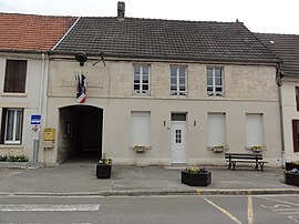 The town hall and school of Parfondru | |
 Parfondru  Parfondru | |
Coordinates:  49°31′42″N 3°42′41″E / 49.5283°N 3.7114°E / 49.5283; 3.7114Coordinates: 49°31′42″N 3°42′41″E / 49.5283°N 3.7114°E / 49.5283; 3.7114 49°31′42″N 3°42′41″E / 49.5283°N 3.7114°E / 49.5283; 3.7114Coordinates: 49°31′42″N 3°42′41″E / 49.5283°N 3.7114°E / 49.5283; 3.7114 | |
| Country | France |
| Region | Hauts-de-France |
| Department | Aisne |
| Arrondissement | Laon |
| Canton | Laon-2 |
| Intercommunality | CA du Pays de Laon |
| Government | |
| • Mayor (2020–2026) | Jean-Luc Lienard |
| Area 1 | 9.08 km2 (3.51 sq mi) |
| Population (Jan. 2018)[1] | 349 |
| • Density | 38/km2 (100/sq mi) |
| Time zone | UTC+01:00 (CET) |
| • Summer (DST) | UTC+02:00 (CEST) |
| INSEE/Postal code | 02587 /02840 |
| Elevation | 69–189 m (226–620 ft) (avg. 80 m or 260 ft) |
| 1 French Land Register data, which excludes lakes, ponds, glaciers > 1 km2 (0.386 sq mi or 247 acres) and river estuaries. | |

Parfondru (French pronunciation: [paʁfɔ̃dʁy]) is a commune in the Aisne department in Hauts-de-France in northern France.
Population[]
|
|
See also[]
References[]
- ^ "Populations légales 2018". INSEE. 28 December 2020.
| Wikimedia Commons has media related to Parfondru. |
show
| |
|---|---|
| Prefecture |
|
| Subprefectures |
|
| Other |
|
| show Authority control | |
|---|---|
| General |
|
| National libraries | |
This Laon arrondissement geographical article is a stub. You can help Wikipedia by . |
- v
- t
Retrieved from ""
Categories:
- Communes of Aisne
- Laon arrondissement geography stubs
Hidden categories:
- Articles to be expanded from December 2008
- All articles to be expanded
- Geography articles needing translation from French Wikipedia
- Articles with short description
- Short description is different from Wikidata
- Infobox mapframe without OSM relation ID on Wikidata
- Coordinates on Wikidata
- Pages using infobox settlement with image map1 but not image map
- Commons category link from Wikidata
- Articles with VIAF identifiers
- Articles with BNF identifiers
- Articles with WorldCat-VIAF identifiers
- Aisne communes articles needing translation from French Wikipedia
- All stub articles
- Pages using the Kartographer extension