Pike County, Ohio
Pike County | |
|---|---|
U.S. county | |
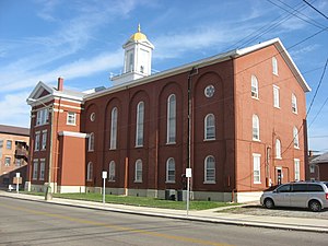 Pike County Courthouse in Waverly. | |
 Seal | |
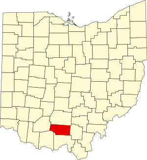 Location within the U.S. state of Ohio | |
 Ohio's location within the U.S. | |
| Coordinates: 39°05′N 83°04′W / 39.08°N 83.07°W | |
| Country | |
| State | |
| Founded | February 1, 1815[1] |
| Named for | Zebulon Pike |
| Seat | Waverly |
| Largest city | Waverly |
| Area | |
| • Total | 444 sq mi (1,150 km2) |
| • Land | 440 sq mi (1,100 km2) |
| • Water | 3.7 sq mi (10 km2) 0.8%% |
| Population (2020) | |
| • Total | 27,088 |
| • Density | 61/sq mi (24/km2) |
| Time zone | UTC−5 (Eastern) |
| • Summer (DST) | UTC−4 (EDT) |
| Congressional district | 2nd |

Pike County is a county located in the Appalachian (southern) region of the U.S. state of Ohio. As of the 2020 census, the population was 27,088.[2] Its county seat is Waverly.[3] The county is named for explorer Zebulon Pike.[4]
History[]
Pike County was organized on February 1, 1815, from portions of Scioto, Ross, and Adams Counties, and was named in honor of Zebulon Pike, the explorer and soldier who had recently been killed in the War of 1812. Pike County was the site of the Pike County Massacre where eight members of the Rhoden family were shot and killed the evening of April 21 - 22, 2016. [5]
Geography[]
According to the U.S. Census Bureau, the county has a total area of 444 square miles (1,150 km2), of which 440 square miles (1,100 km2) is land and 3.7 square miles (9.6 km2) (0.8%) is water.[6]
Adjacent counties[]
- Ross County (north)
- Jackson County (east)
- Scioto County (south)
- Adams County (southwest)
- Highland County (west)
Demographics[]
| Historical population | |||
|---|---|---|---|
| Census | Pop. | %± | |
| 1820 | 4,253 | — | |
| 1830 | 6,024 | 41.6% | |
| 1840 | 7,626 | 26.6% | |
| 1850 | 10,953 | 43.6% | |
| 1860 | 13,643 | 24.6% | |
| 1870 | 15,447 | 13.2% | |
| 1880 | 17,927 | 16.1% | |
| 1890 | 17,482 | −2.5% | |
| 1900 | 18,172 | 3.9% | |
| 1910 | 15,723 | −13.5% | |
| 1920 | 14,151 | −10.0% | |
| 1930 | 13,876 | −1.9% | |
| 1940 | 16,113 | 16.1% | |
| 1950 | 14,607 | −9.3% | |
| 1960 | 19,380 | 32.7% | |
| 1970 | 19,114 | −1.4% | |
| 1980 | 22,802 | 19.3% | |
| 1990 | 24,249 | 6.3% | |
| 2000 | 27,695 | 14.2% | |
| 2010 | 28,709 | 3.7% | |
| 2020 | 27,088 | −5.6% | |
| U.S. Decennial Census[7] 1790-1960[8] 1900-1990[9] 1990-2000[10] 2020 [11] | |||
2000 census[]
As of the census[12] of 2000, there were 27,695 people, 10,444 households, and 7,665 families living in the county. The population density was 63 people per square mile (24/km2). There were 11,602 housing units at an average density of 26 per square mile (10/km2). The racial makeup of the county was 96.72% White, 0.89% Black or African American, 0.74% Native American, 0.18% Asian, 0.04% Pacific Islander, 0.07% from other races, and 1.36% from two or more races. 0.56% of the population were Hispanic or Latino of any race.
There were 10,444 households, out of which 35.50% had children under the age of 18 living with them, 56.80% were married couples living together, 11.90% had a female householder with no husband present, and 26.60% were non-families. 22.80% of all households were made up of individuals, and 10.40% had someone living alone who was 65 years of age or older. The average household size was 2.61 and the average family size was 3.04.
In the county, the population was spread out, with 27.20% under the age of 18, 8.90% from 18 to 24, 28.90% from 25 to 44, 21.50% from 45 to 64, and 13.60% who were 65 years of age or older. The median age was 35 years. For every 100 females there were 95.40 males. For every 100 females age 18 and over, there were 92.50 males.
The median income for a household in the county was $31,649, and the median income for a family was $35,934. Males had a median income of $32,379 versus $20,761 for females. The per capita income for the county was $16,093. About 15.10% of families and 18.60% of the population were below the poverty line, including 23.20% of those under age 18 and 13.60% of those age 65 or over.
2010 census[]
As of the 2010 United States Census, there were 28,709 people, 11,012 households, and 7,743 families living in the county.[13] The population density was 65.2 inhabitants per square mile (25.2/km2). There were 12,481 housing units at an average density of 28.3 per square mile (10.9/km2).[14] The racial makeup of the county was 96.6% white, 0.9% black or African American, 0.5% American Indian, 0.2% Asian, 0.2% from other races, and 1.6% from two or more races. Those of Hispanic or Latino origin made up 0.7% of the population.[13] In terms of ancestry, 19.3% were German, 14.8% were Irish, 12.9% were English, and 12.5% were American.[15]
Of the 11,012 households, 34.6% had children under the age of 18 living with them, 51.2% were married couples living together, 13.1% had a female householder with no husband present, 29.7% were non-families, and 25.1% of all households were made up of individuals. The average household size was 2.56 and the average family size was 3.02. The median age was 39.2 years.[13]
The median income for a household in the county was $35,912 and the median income for a family was $43,010. Males had a median income of $40,645 versus $27,422 for females. The per capita income for the county was $17,494. About 18.0% of families and 23.6% of the population were below the poverty line, including 32.7% of those under age 18 and 15.2% of those age 65 or over.[16]
Politics[]
Pike County used to be very strongly Democratic in presidential elections, being the only county in the state to vote for Adlai Stevenson in 1956. However, things have changed recently; Bill Clinton in 1996 was the last Democrat to win the county, though Barack Obama lost here by only one vote in 2012. In 2016 the County took a sharp turn to the right, as Republican Donald Trump won over 65% of the vote in the county, after Mitt Romney won it by only a single vote 4 years prior.
Government[]
The Garnet A. Wilson Public Library serves area communities from its main branch in Waverly, Ohio and from its branches in Beaver, Piketon, and Western Pike County.
In 2005, the library loaned more than 238,000 items to its 20,000 cardholders. Total holding are over 91,000 volumes with over 210 periodical subscriptions.[18]

Waverly Library
Beaver Library

Piketon Library
Western Pike Library


Pike County has adopted a county flag with an unusual shape, rounded at the fly end. It bears fourteen stars, representing the county's townships, and various industry symbols within a circular emblem, all upon a green field.[19] The flag is through and through except for the emblem.[20]
Communities[]

City[]
- Waverly (county seat)
Villages[]
Townships[]
https://web.archive.org/web/20160715023447/http://www.ohiotownships.org/township-websites
Census-designated places[]
Unincorporated communities[]
- Buchanan
- Camp
- Daleyville
- Idaho
- Jasper
- Latham
- Morgantown
- Sargents
- Spellman Crossing
- Wakefield
American Airlines Flight 77[]


On the morning of September 11, 2001, American Airlines Flight 77 was a scheduled American Airlines domestic transcontinental passenger flight from Washington Dulles International Airport in Dulles, Virginia, to Los Angeles International Airport in Los Angeles, California. The Boeing 757-223 aircraft serving the flight was hijacked by five Saudi men affiliated with al-Qaeda as it flew over Southern Ohio.[21] It is believed that the hijackers abruptly turned the plane around as it flew in the vicinity over Pike County[22] and it was subsequently crashed into the Pentagon in Arlington County, Virginia, near Washington, D.C.
Flight 77 was scheduled to depart for Los Angeles at 08:10; 58 passengers boarded through Gate D26, including the five hijackers. The 53 other passengers on board excluding the hijackers were 26 men, 22 women, and five children ranging in age from three to eleven. Less than 35 minutes into the flight, as the plane crossed over the Ohio/West Virginia border, the hijackers stormed the cockpit and forced the passengers, crew, and pilots to the rear of the aircraft. Hani Hanjour, one of the hijackers who was trained as a pilot, assumed control of the flight. Unlike the other three flights (American Airlines Flight 11, United Airlines Flight 175, and United Airlines Flight 93) there were no reports of anyone being stabbed or a bomb threat and the pilots were possibly not immediately killed but herded to the back of the plane with the rest of the passengers.
Two minutes later, at 08:56, the plane's transponder was switched off. The hijackers set the flight's autopilot on a course heading east towards Washington, D.C. and the plane made an abrupt turn South and East as it flew over Pike County.[23] The weather was beautiful and clear throughout much of the United States, and Flight 77 was visible to individuals on the ground and to other aircraft in the surrounding area. Local farmers working in Pike and Ross Counties later reported to authorities seeing a large aircraft making a 180 degree turn and descending, before heading back East.
The FAA was aware at this point there was an emergency on board the airplane. By this time, Flight 11 had already crashed into the North Tower of the World Trade Center and Flight 175 was known to have been hijacked and was within minutes of striking the South Tower. After learning of this second hijacking involving an American Airlines aircraft and the hijacking involving United Airlines, American Airlines' executive vice president Gerard Arpey ordered a nationwide ground stop for the airline. The Indianapolis Air Traffic Control Center, as well as American Airlines dispatchers, made several failed attempts to contact the aircraft. At the time the airplane was hijacked over Southern Ohio, it was flying over an area of limited radar coverage. With air controllers unable to contact the flight by radio, an Indianapolis official declared that it had possibly crashed at 09:09.
As the plane neared Washington, D.C., it was detected again by Dulles controllers on radar screens, turning and descending rapidly. Controllers initially thought this was a military fighter, due to its high speed and maneuvering. Reagan Airport controllers asked a passing Air National Guard Lockheed C-130 Hercules to identify and follow the aircraft. The pilot, Lieutenant Colonel Steven O'Brien, told them it was a Boeing 757 or 767, and that its silver fuselage meant it was probably an American Airlines jet. He had difficulty picking out the airplane in the "East Coast haze", but then saw a "huge" fireball and assumed it had hit the ground. Approaching the Pentagon, he saw the impact site on the building's west side and reported to Reagan control, "Looks like that aircraft crashed into the Pentagon, sir."

According to the 9/11 Commission Report, as Flight 77 was 5 miles (8.0 km) west-southwest of the Pentagon, it made a 330-degree spiral turn clockwise. At the end of the turn, it was descending through 2,200 feet (670 m), pointed toward the Pentagon and downtown Washington. Hani Hanjour advanced the throttles to maximum power and dove toward the Pentagon.
The hijackers crashed the aircraft into the western side of the Pentagon at 09:37 AM ET, killing all 64 aboard (including six crew and themselves) and another 125 in the building. The airplane took eight-tenths of a second to fully penetrate 310 feet (94 m) into the three outermost of the building's five rings and unleashed a fireball that rose 200 feet (61 m) above the building.
In Popular Culture[]
Pike County is briefly shown in the 2013 American action film, White House Down, directed by Roland Emmerich. Towards the climax of the film there is a scene in which terrorists hack into NORAD and launch a missile at Air Force One from the Portsmouth Gaseous Diffusion Plant located in the county, killing everyone on board. [24]
See also[]
- National Register of Historic Places listings in Pike County, Ohio
- Pike County, Ohio, shootings
References[]
- ^ "Ohio County Profiles: Pike County" (PDF). Ohio Department of Development. Archived from the original (PDF) on 2007-06-21. Retrieved 2007-04-28.
- ^ 2020 census
- ^ "Find a County". National Association of Counties. Archived from the original on 2011-05-31. Retrieved 2011-06-07.
- ^ "Pike County data". Ohio State University Extension Data Center. Retrieved 2007-04-28.[dead link]
- ^ https://www.fox19.com/news/pike-county-massacre/
- ^ "2010 Census Gazetteer Files". United States Census Bureau. August 22, 2012. Archived from the original on May 4, 2014. Retrieved February 10, 2015.
- ^ "U.S. Decennial Census". United States Census Bureau. Retrieved February 10, 2015.
- ^ "Historical Census Browser". University of Virginia Library. Retrieved February 10, 2015.
- ^ Forstall, Richard L., ed. (March 27, 1995). "Population of Counties by Decennial Census: 1900 to 1990". United States Census Bureau. Retrieved February 10, 2015.
- ^ "Census 2000 PHC-T-4. Ranking Tables for Counties: 1990 and 2000" (PDF). United States Census Bureau. April 2, 2001. Retrieved February 10, 2015.
- ^ 2020 census
- ^ "U.S. Census website". United States Census Bureau. Retrieved 2008-01-31.
- ^ Jump up to: a b c "DP-1 Profile of General Population and Housing Characteristics: 2010 Demographic Profile Data". United States Census Bureau. Archived from the original on 2020-02-13. Retrieved 2015-12-27.
- ^ "Population, Housing Units, Area, and Density: 2010 - County". United States Census Bureau. Archived from the original on 2020-02-13. Retrieved 2015-12-27.
- ^ "DP02 SELECTED SOCIAL CHARACTERISTICS IN THE UNITED STATES – 2006-2010 American Community Survey 5-Year Estimates". United States Census Bureau. Archived from the original on 2020-02-13. Retrieved 2015-12-27.
- ^ "DP03 SELECTED ECONOMIC CHARACTERISTICS – 2006-2010 American Community Survey 5-Year Estimates". United States Census Bureau. Archived from the original on 2020-02-13. Retrieved 2015-12-27.
- ^ Leip, David. "Dave Leip's Atlas of U.S. Presidential Elections". uselectionatlas.org. Retrieved 2018-05-03.
- ^ "2005 Ohio Public Library Statistics:Statistics by County and Town". State Library of Ohio. Archived from the original on September 24, 2006. Retrieved November 10, 2006.
- ^ "Pike". County Flags. Columbus, Ohio: Ohio Statehouse Museum. Archived from the original on July 20, 2019. Retrieved July 20, 2019.
- ^ Stanley, Stephanie (November 9, 2015). "PCPADV hosts discussion about teen dating violence". . Waverly, Ohio. Retrieved July 20, 2019.
- ^ "The Pentagon 9/11" (PDF).
- ^ "America Airlines Flight 77 is Hijacked Above Southern Ohio". September 11, 2001 Research & Archives. Retrieved 2021-04-27.
- ^ Sciolino, Elaine; Jr, John H. Cushman (2001-09-13). "AFTER THE ATTACKS: AMERICAN FLIGHT 77; A Route Out of Washington, Horribly Changed". The New York Times. ISSN 0362-4331. Retrieved 2021-04-27.
- ^ Emmerich, Roland (2013-06-26), White House Down (Action, Drama, Thriller), Channing Tatum, Jamie Foxx, Maggie Gyllenhaal, Jason Clarke, Columbia Pictures, Mythology Entertainment, Centropolis Entertainment, retrieved 2020-11-22
External links[]
| show Places adjacent to Pike County, Ohio |
|---|
| show Municipalities and communities of Pike County, Ohio, United States |
|---|


Coordinates: 39°05′N 83°04′W / 39.08°N 83.07°W
| show Authority control |
|---|
- Ohio counties
- Pike County, Ohio
- Appalachian Ohio
- Counties of Appalachia
- 1815 establishments in Ohio
- Populated places established in 1815