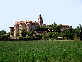
Pommiers-en-Forez
Pommiers-en-Forez | |
|---|---|
Commune | |
 Priory | |
 Coat of arms | |
show Location of Pommiers-en-Forez | |
 Pommiers-en-Forez | |
| Coordinates: 45°49′48″N 4°03′57″E / 45.83°N 4.0658°ECoordinates: 45°49′48″N 4°03′57″E / 45.83°N 4.0658°E | |
| Country | France |
| Region | Auvergne-Rhône-Alpes |
| Department | Loire |
| Arrondissement | Roanne |
| Canton | Boën-sur-Lignon |
| Intercommunality | Vals d'Aix et d'Isable |
| Government | |
| • Mayor (2020–2026) | Henri Cherbland[1] |
| Area 1 | 23.84 km2 (9.20 sq mi) |
| Population (Jan. 2018)[2] | 360 |
| • Density | 15/km2 (39/sq mi) |
| Time zone | UTC+01:00 (CET) |
| • Summer (DST) | UTC+02:00 (CEST) |
| INSEE/Postal code | 42173 /42260 |
| Elevation | 318–408 m (1,043–1,339 ft) (avg. 350 m or 1,150 ft) |
| 1 French Land Register data, which excludes lakes, ponds, glaciers > 1 km2 (0.386 sq mi or 247 acres) and river estuaries. | |


Pommiers-en-Forez (French pronunciation: [pɔmje ɑ̃ fɔʁɛ], literally Pommiers in Forez; before 2020: Pommiers)[3] is a commune in the Loire department in central France.
Population[]
|
|
See also[]
References[]
- ^ "Répertoire national des élus: les maires". data.gouv.fr, Plateforme ouverte des données publiques françaises (in French). 2 December 2020.
- ^ "Populations légales 2018". INSEE. 28 December 2020.
- ^ Décret n° 2020-175 26 February 2020 (in French)
| Wikimedia Commons has media related to Pommiers-en-Forez. |
| show Authority control |
|---|
This Loire geographical article is a stub. You can help Wikipedia by . |
Categories:
- Communes of Loire (department)
- Loire geography stubs