Reuilly-Sauvigny
show This article may be expanded with text translated from the corresponding article in French. (December 2008) Click [show] for important translation instructions. |
Reuilly-Sauvigny | |
|---|---|
Commune | |
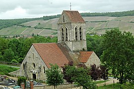 The church of Reuilly-Sauvigny | |
 Coat of arms | |
show Location of Reuilly-Sauvigny | |
 Reuilly-Sauvigny | |
| Coordinates: 49°03′32″N 3°33′30″E / 49.0589°N 3.5583°ECoordinates: 49°03′32″N 3°33′30″E / 49.0589°N 3.5583°E | |
| Country | France |
| Region | Hauts-de-France |
| Department | Aisne |
| Arrondissement | Château-Thierry |
| Canton | Essômes-sur-Marne |
| Intercommunality | |
| Government | |
| • Mayor (2020–2026) | Daniel Saroul[1] |
| Area 1 | 6.54 km2 (2.53 sq mi) |
| Population (Jan. 2018)[2] | 197 |
| • Density | 30/km2 (78/sq mi) |
| Time zone | UTC+01:00 (CET) |
| • Summer (DST) | UTC+02:00 (CEST) |
| INSEE/Postal code | 02645 /02850 |
| Elevation | 62–241 m (203–791 ft) (avg. 67 m or 220 ft) |
| 1 French Land Register data, which excludes lakes, ponds, glaciers > 1 km2 (0.386 sq mi or 247 acres) and river estuaries. | |


Reuilly-Sauvigny is a commune in the Aisne department in Hauts-de-France in northern France.
Geography[]
The village is located in Condé-en-Brie, in the south of the Aisne department, bordering on the Marne department. About 10 kilometres to the east of the commune is Château-Thierry, which is located on a hillside in Marne.
History[]
Two surrounding fords meant it was easiest to cross la Marne at the top of the commune, making it a strategic point during the two World wars, during which Reuilly was very heavily damaged.
Heraldry[]
The Reuilly-Sauvigny coat of arms is emblazoned with: Green with a golden sword, three lioncubs stitched on a silver waving fabric
Demographics[]
Since the beginning of the twenty-first century, the Census for areas with less than 10,000 inhabitants has taken place every five years. In Reuilly-Sauvigny this happened in 2007 and 2012. Any Census figures from other years are estimates.
Sights[]
- Église Saint Blaise, dating back to the 13th century
Population[]
| Year | Pop. | ±% |
|---|---|---|
| 2006 | 231 | — |
| 2007 | 234 | +1.3% |
| 2008 | 233 | −0.4% |
| 2009 | 230 | −1.3% |
| 2010 | 229 | −0.4% |
| 2011 | 226 | −1.3% |
| 2012 | 223 | −1.3% |
| 2013 | 226 | +1.3% |
| 2014 | 226 | +0.0% |
| 2015 | 217 | −4.0% |
| 2016 | 209 | −3.7% |
Politics[]
Presidential Elections 2nd Round [3][]
| Election | Winning Candidate | Party | % | |
|---|---|---|---|---|
| 2017 | Emmanuel Macron | EM | 51.28 | |
| 2012 | François Hollande | PS | 58.88 | |
| 2007 | Nicolas Sarkozy | UMP | 55.32 | |
| 2002 | Jacques Chirac | RPR | 71.56 | |
See also[]
References[]
- ^ "Répertoire national des élus: les maires". data.gouv.fr, Plateforme ouverte des données publiques françaises (in French). 2 December 2020.
- ^ "Populations légales 2018". INSEE. 28 December 2020.
- ^ http://www.lemonde.fr/data/france/presidentielle-2017/
| Wikimedia Commons has media related to Reuilly-Sauvigny. |
This Château-Thierry arrondissement geographical article is a stub. You can help Wikipedia by . |
- Communes of Aisne
- Château-Thierry arrondissement geography stubs