Road signs in Indonesia
 | This page is a candidate to be copied to Wikimedia Commons. If the page can be re-written into an encyclopedic article, please do so and remove this message. |

Road signs in Indonesia are standarized road signs similar to those used in other nations but with certain distinctions. As a former Dutch colony, until the 1970s road signs in Indonesia closely followed The Netherlands rules on road signs. Nowadays, Indonesian road sign design are a mix of European, US MUTCD, New Zealand, and Japanese road sign features. According to the 2014 Minister of Transport's Regulation No. 13 concerning Traffic Signs,[1] the official typeface for road signs in Indonesia is Clearview. Indonesia formerly used FHWA Series fonts (Highway Gothic) as the designated typeface though the rules are not being implemented properly.
Indonesian road signs use Indonesian, the official and the national language of Indonesia. However, English is also used for important public places such as tourist attractions and airports. Bilingual signs can be found in tourist areas such as Bali.
Indonesia signed the Vienna Convention on Road Signs and Signals but have yet to ratify the Convention.
Warning signs[]
Warning signs warn of possible dangers or unusual conditions ahead and alert motorists on the hazards to expect. Warning signs in Indonesia used to closely follow US MUTCD and Japanese diamond-shaped with yellow background and black-and-yellow outline but recently they change it to full black outline.

Open railroad crossing ahead

Railroad crossing ahead

Curve

Double curves

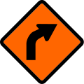
Sharp turn

Double sharp turns

Series of curves

Spiral loop

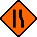
Road narrows

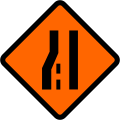
Road narrows on right

Narrow bridge

Steep descent

Hazardous descent

Steep ascent

Hazardous ascent

Slippery road

Dip

Road Hump

Uneven road

Loose gravel

Falling rocks

Traffic lights ahead

Roundabout ahead

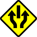
Start of dual carriageway
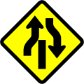
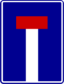
End of dual carriageway
One-way dual carriageway

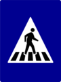
Pedestrian crossing

Pedestrians

Children

Bicycles

Farm animals crossing

Wild animals crossing

Other Danger ahead (Usually accompanied with a supplementary sign beneath)

Roadworks ahead
Maximum height ahead

Maximum width ahead

Low flying aircraft

Cross-wind

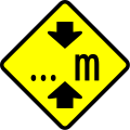
Two way traffic

Opening or swing bridges ahead


Intersections[]

Crossroads

Priority at crossroad junction

Merging traffic on the right

Priority merging traffic from the right

Priority merging traffic from the left
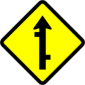
Side road on left

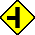
Side road on right

Staggered junction, first on left
Staggered junction, first on right

3-way junction

Priority side road from right

T-Junction

Y-Junction


Regulatory signs[]
Prohibitory signs[]
Prohibitory signs in Indonesia are circular and have a red border with diagonal bars except for Stop, Give way, and Railroad Crossing signs.

Stop

Give way

Customs

Toll plaza

Single-track railroad crossing

Multiple-tracks railroad crossing

No entry
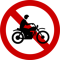
No motorcycles and mopeds

No Cars

No vehicles (combination)

No bicycles
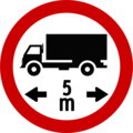
Maximum length for motorised vehicles
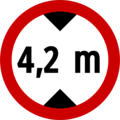
Maximum height limit[2]

Maximum width limit

Maximum Weight limit

Maximum Weight limit per axle

No left turn

No U-turn

No right turn or U-turn

Minimum distance between cars
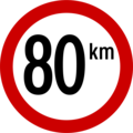
Maximum speed limit in kilometers per hour (km/h)

Give way to oncoming traffic

End of speed restriction limit

No stopping
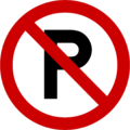
No parking

No passing


Mandatory signs[]
Mandatory signs in Indonesia follows the "Type A Mandatory Signs" as prescribed by the Vienna Convention, which is the European-style white-on-blue circular signs with addition of white border

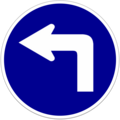
Follow left

Follow right
Turn left
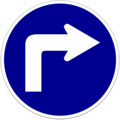
Turn right

Go Straight
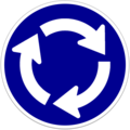
Roundabout

Straight ahead or left ahead

Straight ahead or right ahead

Keep left
Keep right

Pass either side
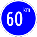
Minimum speed limit in kilometers per hour (km/h)
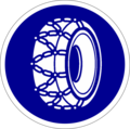
Tyre chain

Motorcycle lane

Buses-only lane

Truck-only lane

Pedestrians only

Equestrians only

Bikes only

Rickshaws only

Carts only
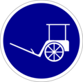
Horse carriage only

Non-motorized vehicles only

End of minimum speed limit

End of tyre chain usage


Directional signs[]
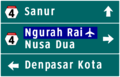
4-way directional sign. Ngurah Rai International Airport is highlighted in blue as it is a public facility

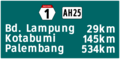
3-way directional sign. Note the Indonesian National Highway number hexagon
Exit to tolled freeway
National route distance sign (differs by island)
Entrance to tolled expressway

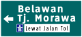
3-way directional sign. Kawasan Kota Tua, a tourist attraction, is highlighted in brown

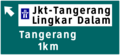
4 way intersection directional sign. 'TOL PURBALEUNYI, a toll road, is highlighted in white and bears the international highway symbol, while Stasiun KA Kota, a train station, is highlighted in blue.


Tolled freeway signs[]
Most of the signs in this section are custom-made by the tollroad operator and unavailable in the current regulations.
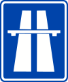
Freeway Symbol

Tolled freeway begins

Tolled freeway ends

Tolled freeway restrictions for non-motorised vehicles ("Toll Road only for motorised vehicles with four or more wheels")
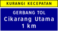
Toll plaza ahead

Exit ahead (1 km)

Exit ahead (500 m)

Exit ahead (300 m)

Exit sign (butterfly gantry sign placed in between ramp)

Interchange ahead (1 km)

Interchange ahead (500m)

Interchange ahead (300m)

Interchange exit
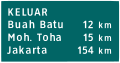
Freeway distance sign

Freeway location marker with meters, placed in each 200 m of the freeway

Service area ahead (1 km)
Service area ahead (500 m)

Service area ahead (~300 m)

Bridge name

Runaway ramp. The 500m distance is omitted in 300m before the ramp

Lane directory

Advisory sign (Right lane only for passing)

Prohibition sign (Passing on left prohibited)

Distance guidance ahead [3]
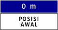
Distance guidance (0m) [3]

Distance guidance (50m-unsafe distance) [3]

Distance guidance (100m-safe distance) [3]

Toll plaza (pay toll)

Toll plaza (take ticket)
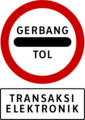
Toll plaza (electronic payment)

Toll plaza height limit [2] (might be omitted in some toll plazas)

Warning sign (Fog)

Warning sign (Crosswind)


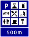
Information signs[]

City limits
End city limits

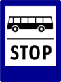
Bus terminal

Train station

Harbour

Airport
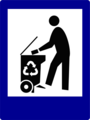
Garbage/Waste disposal

Landfill

Post office

Payphone
Bus stop

Taxi stand
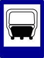
Transit stop
Pedestrian crossing

Parking
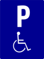
Wheelchair parking

Tunnel

End of tunnel
Tsunami evacuation route

Earthquake evacuation route

Volcano eruption evacuation route

Emergency muster zone

Refuge camp

Refuge centre

Mosque

Church

Vihara

Hindu Temple

Hospital

Clinic, Community Health Centre

Pharmacy

Petrol station

Scheduled service station

Emission service station

Weigh station

Museum

Market

Restaurant

Café
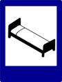
Lodging

Motor services

Park

Cross-country route

Tent camp

Caravan camp

Camp

Villa

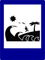
Beach

Open sports field

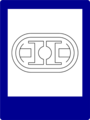
Indoor sports centre

Swimming pool
Stadium

School

Library

One way
No through road

U-turn permitted

Motorised vehicles only


Temporary signs[]
Temporary signs generally follow New Zealand design, albeit with Clearview typeface instead of Highway Gothic typeface.

Curve left
Curve right

Road narrows

Road widens

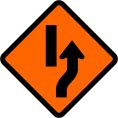
Narrow left
Narrow right

Widen left

Widen right
Lane ends on left

Lane ends on right
Added lane on left

Added lane on right

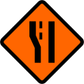
Narrow section

Slippery road

Uneven surface

Loose gravel
Diversion to the right

Diversion to the left

Diversion to the right ends

Diversion to the left ends

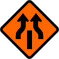
Traffic divided
Divided traffic ends

Traffic divided (two-way)

Divided traffic ends (two-way)

Warning sign (accompanied by a supplementary sign beneath)

Road workers

Maximum height
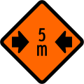
Maximum width

Two-way traffic

Roadwork traffic controllers

Worded warning sign (in this case "Road Work")


See also[]
References[]
- ^ http://hubdat.dephub.go.id/km/tahun-2014/1626-peraturan-menteri-perhubungan-nomor-pm-13-tahun-2014-tentang-rambu-lalu-lintas/download
- ^ a b Indonesian vehicle maximum height standard, according to Article 54, Paragraph (1)c of the Indonesian Republic Government Regulation No. 55 of 2012 (shown in regulations as in milimeters, and height should not exceed 1.7 times vehicle breadth)
- ^ a b c d Only found in the Jagorawi and the Jakarta-Serpong freeway
Road signs in Asia | |
|---|---|
| Sovereign states | |
| States with limited recognition | |
| Dependencies and other territories | |
| |
- Road transport in Indonesia
- Road signs by country