Road signs in Hong Kong

Road signs in Hong Kong are standardized by the Transport Department.[1] Due to being a former British territory, the road signage in Hong Kong is similar to road signs in the United Kingdom, with the addition of Traditional Chinese characters.
Design and language[]
Road signs in Hong Kong closely follow those used in the United Kingdom, and complies with the Vienna Convention on Road Signs and Signals, a legacy of the city's previous British overseas territory status. Signs normally use the Transport Medium typeface on dark backgrounds or Transport Heavy on light backgrounds, which is identical to the use in the United Kingdom, Republic of Ireland and most of the current and previous British Overseas Territories
Road signs placed in the 2000s to 2010s commonly use Arial Narrow or Helvetica, with or without a modified letter 'L'; street signs sometimes also use Helvetica. The newest signs built after 2016 have increasingly resumed the use of Transport; some signs on recently completed expressways use Transport Heavy on dark backgrounds.
Writing system on the traffic signs comprises British English and traditional Chinese, two official languages of Hong Kong, in an order of English above Traditional Chinese.
Warnings[]
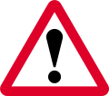
Signs warning of hazardous conditions or dangerous situations (e.g. "Intersection" or "Steep incline ahead" bear a black-on-white symbol inside a red-bordered triangle (point uppermost).[2]

Stop or give way signs ahead (with distance to line ahead given below)
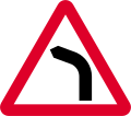
Bend to left ahead (right if symbol reversed)
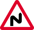
Double bend ahead first to right (symbol may be reversed)

Two-way traffic ahead

Two-way traffic across a one-way road ahead

Dual carriageway ends ahead

Roundabout ahead

Road narrows ahead on right (left if symbol reversed)

Road narrows on both sides ahead

Sharp deviation of route (may be used with amber border)

Steep hill upwards ahead

Steep hill downwards ahead

Traffic lights ahead

Traffic Accident blackspot ahead

Pedestrian Accident blackspot ahead.

Cross roads ahead

Staggered junction ahead (symbol may be reversed)

Side road ahead (symbol may be reversed)

T-junc-tion ahead (symbol may be reversed)

Traffic merges from left (right if symbol reversed)
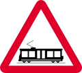
Tramway crossing ahead
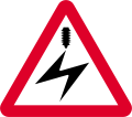
Over-head electric cable ahead

Quay-side or river bank ahead

Fog or mist might appear on the road when it's could or rainy

Risk of falling or fallen rocks ahead
Pedestrians on road ahead

Pedestrian crossing ahead

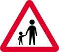
Children ahead

Disabled people may appear on the road

Blind People might appear on the road

Cycles ahead

Horses ahead
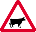
Cattle ahead
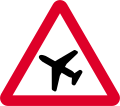
Low-flying aircraft or sudden aircraft noise ahead
Uneven road ahead

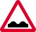
Road hump ahead

Reduce speed now

Advice for cyclists

Distance to 'Give way' line
Distance to 'Stop' line


Regulatory[]
With the exception of the special shapes used for "Stop" and "Yield" signs (respectively, an octagon and a downward-pointing triangle), signs giving orders are circular and are of two kinds:[3]
Prohibitory signs (e.g. "No left turn") take the form of a black-on-white symbol inside a red-bordered circle, sometimes with the addition of a red slash through the symbol. Mandatory signs (e.g. "Turn right only") bear a white symbol on a blue disk.

Give way to traffic on major road
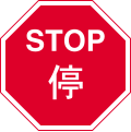
Stop and give way
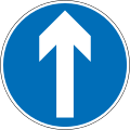
Ahead only
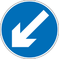
Keep left (right if symbol reversed)

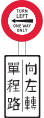
Turn left (right if symbol reversed)

Turn left at junction ahead (right if symbol reversed)

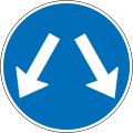
Vehicles may pass either side to reach same destination
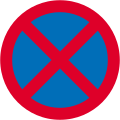
No stopping

No waiting (parking)
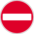
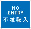
No entry

Police checkpoint or roadblock (stop at sign)

School crossing patrol (stop at sign)
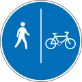
Segregated path between pedestrian and cyclist paths
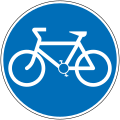
Route to be used by pedal cycles only (no motor vehicles)

Cyclists must dismount and push your bicycle
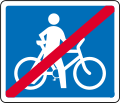
End of cycling dismounting

Light rail transit (vehicles or trams only)
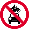
All vehicles prohibited, except permitted vehicles
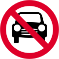
No motor vehicles
No motor vehicles excluding motorcycles

No motorcycles

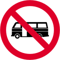
Large buses are prohibited
Minibuses are prohibited
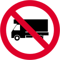
No access to trucks
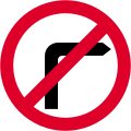
No right turn (no left turn if symbol reversed)
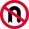
No U-turn

No pedestrians

No bicycles
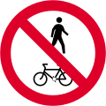
No pedestrians, pedestrian controlled vehicles, bicycles and tricycles

Pedestrian priority zone

Rickshaws and handcarts are prohibited in this area
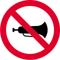
No use of horn

No overtaking
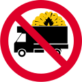
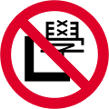
Cargo trucks transporting hazardous materials is prohibited
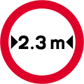
No vehicles over width shown
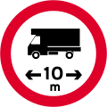
No vehicles over length shown

No vehicles over height shown

No vehicles over gross vehicle weight shown
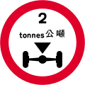
No vehicles over gross axle weight shown
No learner drivers

Way in for vehicles
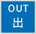
Way out for vehicles
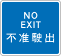
No way out for vehicles
No way in for vehicles

Single track road with passing places

Passing place (on narrow roads)

Except for access if no alternative route
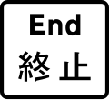
End of prohibition, restriction, and construction

Distance of prohibition/restriction
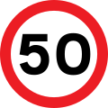
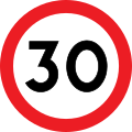
Speed limit in kilometres per hour (km/h)

Parking for all cars

Parking for buses and coaches only

Motorway begins

Motorway ends


Temporary/Construction[]
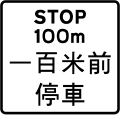
Temporary road signs (e.g. Red rectangular signs with instructions in white)[4]

Wait on red light
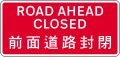
Road ahead is closed

Road closed

Direction signs for temporary routes with destination

Worded warning sign (wording may be varied)

Temporary route for pedestrians

Temporary pedestrian crossing closure

Road work ahead
Danger ahead

Slippery road ahead

Loose chippings ahead
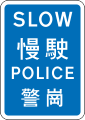
Slow down, police is near by.

Accident ahead, follow direction of police

Police roadblock ahead

Manually operated temporary 'Stop' sign

Manually operated temporary 'Go' sign


Guide[]
Guide signs are generally rectangular (sometimes pointed at one end in the case of direction signage).[5]

Overhead guide sign on major roads.

Interchange sign to Route 6

Roundabout sign with three exits.

Motorway route number

Direction sign with destination

Direction to MTR station

Direction to vehicular ferry pier

Direction to parking place

Speed camera ahead
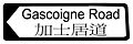
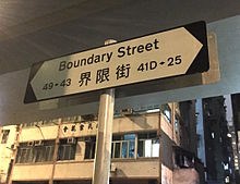
Street direction sign

Street direction sign with numbers
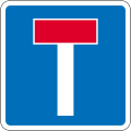
No through road

Advance warning of no through road on left

Advance warning of no through road on right

Location of traffic survey

Vehicles must stop at a census traffic point

Countdown markings to indicate distance from exit (100m)

Countdown markings to indicate distance from exit (200m)

Countdown markings to indicate distance from exit (300m)

Tunnel ahead

To cross harbour tunnel


Obsolete[]
Post-Worboys[]

Ahead only

Keep left (right if symbol reversed)

Turn left (right if symbol reversed)

Turn left at junction ahead (right if symbol reversed)
Vehicles may pass either side to reach same destination

Speed limit in kilometres per hour (km/h)


Pre-Worboys[]

One-way traffic

Pedestrian crossing

Turn left
One-way traffic (left)

Turn right

One-way traffic (right)

No through road for motor vehicles

No entry

No Waiting

No Cycling
Speed Limit

National Speed Limit Applies

Parking


References[]
- ^ "Chapter 8: The Language of the Road". Transport Department. Retrieved 2020-12-04.
- ^ "Traffic Signs Giving Warning". Transport Department. Retrieved 2020-12-04.
- ^ "Traffic Signs Giving Orders". Transport Department. Retrieved 2020-12-04.
- ^ "Temporary Signs and Road Markings". Transport Department. Retrieved 2020-12-04.
- ^ "Traffic Signs Giving Information". Transport Department. Retrieved 2020-12-04.
| Wikimedia Commons has media related to Road signs in Hong Kong. |
Road signs in Asia | |
|---|---|
| Sovereign states | |
| States with limited recognition | |
| Dependencies and other territories | |
| |
- Road signs by country
- Transport in Hong Kong