Saint-Paul-en-Cornillon
Saint-Paul-en-Cornillon | |
|---|---|
Commune | |
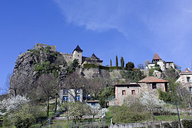 The upper village | |
 Coat of arms | |
show Location of Saint-Paul-en-Cornillon | |
 Saint-Paul-en-Cornillon | |
| Coordinates: 45°23′53″N 4°14′29″E / 45.3981°N 4.2414°ECoordinates: 45°23′53″N 4°14′29″E / 45.3981°N 4.2414°E | |
| Country | France |
| Region | Auvergne-Rhône-Alpes |
| Department | Loire |
| Arrondissement | Saint-Étienne |
| Canton | Firminy |
| Intercommunality | Saint-Étienne Métropole |
| Government | |
| • Mayor (2020–2026) | Sylvie Fayolle[1] |
| Area 1 | 3.72 km2 (1.44 sq mi) |
| Population (Jan. 2018)[2] | 1,361 |
| • Density | 370/km2 (950/sq mi) |
| Time zone | UTC+01:00 (CET) |
| • Summer (DST) | UTC+02:00 (CEST) |
| INSEE/Postal code | 42270 /42240 |
| Elevation | 422–713 m (1,385–2,339 ft) (avg. 430 m or 1,410 ft) |
| 1 French Land Register data, which excludes lakes, ponds, glaciers > 1 km2 (0.386 sq mi or 247 acres) and river estuaries. | |


Saint-Paul-en-Cornillon (French pronunciation: [sɛ̃ pɔl ɑ̃ kɔʁnijɔ̃]; Occitan: Sant Paul jos Cornilhon) is a commune in the Loire department in central France.
Population[]
|
|
Gallery[]
- Castle of Saint Paul en Cornillon (11th Century)

The château

A view from the south

A view from the east


See also[]
References[]
- ^ "Répertoire national des élus: les maires". data.gouv.fr, Plateforme ouverte des données publiques françaises (in French). 2 December 2020.
- ^ "Populations légales 2018". INSEE. 28 December 2020.
| Wikimedia Commons has media related to Saint-Paul-en-Cornillon. |
| show Authority control |
|---|
This Loire geographical article is a stub. You can help Wikipedia by . |
Categories:
- Communes of Loire (department)
- Loire geography stubs