Shelby County, Texas
Shelby County | |
|---|---|
U.S. county | |
 Shelby County Courthouse in Center | |
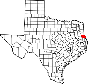 Location within the U.S. state of Texas | |
 Texas's location within the U.S. | |
| Coordinates: 31°47′N 94°08′W / 31.79°N 94.14°W | |
| Country | |
| State | |
| Founded | 1837 |
| Named for | Isaac Shelby |
| Seat | Center |
| Largest city | Center |
| Area | |
| • Total | 835 sq mi (2,160 km2) |
| • Land | 796 sq mi (2,060 km2) |
| • Water | 39 sq mi (100 km2) 4.7%% |
| Population (2010) | |
| • Total | 25,448 |
| • Density | 32/sq mi (12/km2) |
| Time zone | UTC−6 (Central) |
| • Summer (DST) | UTC−5 (CDT) |
| Congressional district | 1st |
| Website | www |

Shelby County is a county located in the far eastern portion of the U.S. state of Texas. As of the 2010 census, its population was 25,448.[1] Its county seat is Center.[2] The county was created in 1835 as a municipality of Mexico and organized as a county in 1837.[3][4] It is named for Isaac Shelby, a soldier in the American Revolution who became the first governor of Kentucky.
Shelby County was formerly represented in the Texas House of Representatives by the Center businessman and conservative Republican Wayne Christian. In 2012, Christian was defeated for renomination by current Representative Chris Paddie.
History[]
Shelby County was formed in 1837. It was named for Isaac Shelby, a soldier from Tennessee during the American Revolution, and first Governor of Kentucky.
Geography[]
According to the U.S. Census Bureau, the county has a total area of 835 square miles (2,160 km2), of which 796 square miles (2,060 km2) are land and 39 square miles (100 km2) (4.7%) are covered by water.[5]
Adjacent counties and parishes[]
- Panola County (north)
- De Soto Parish, Louisiana (northeast)
- Sabine Parish, Louisiana (east)
- Sabine County (south)
- San Augustine County (south)
- Nacogdoches County (southwest)
- Rusk County (northwest)
National protected area[]
- Sabine National Forest (part)
Demographics[]
| Historical population | |||
|---|---|---|---|
| Census | Pop. | %± | |
| 1850 | 4,239 | — | |
| 1860 | 5,362 | 26.5% | |
| 1870 | 5,732 | 6.9% | |
| 1880 | 9,532 | 66.3% | |
| 1890 | 14,365 | 50.7% | |
| 1900 | 20,452 | 42.4% | |
| 1910 | 26,423 | 29.2% | |
| 1920 | 27,464 | 3.9% | |
| 1930 | 28,627 | 4.2% | |
| 1940 | 29,235 | 2.1% | |
| 1950 | 23,479 | −19.7% | |
| 1960 | 20,479 | −12.8% | |
| 1970 | 19,672 | −3.9% | |
| 1980 | 23,084 | 17.3% | |
| 1990 | 22,034 | −4.5% | |
| 2000 | 25,224 | 14.5% | |
| 2010 | 25,448 | 0.9% | |
| 2019 (est.) | 25,274 | [6] | −0.7% |
| U.S. Decennial Census[7] 1850–2010[8] 2010–2014[1] | |||
As of the census[9] of 2000, 25,224 people, 9,595 households, and 6,908 families resided in the county. The population density was 32 people per square mile (12/km2). The 11,955 housing units averaged 15 per square mile (6/km2). The racial makeup of the county was 72.65% White, 19.44% African American, 0.36% Native American, 0.23% Asian, 0.02% Pacific Islander, 5.87% from other races, and 1.44% from two or more races. About 9.87% of the population was Hispanic or Latino of any race.
Of the 9,595 households, 32.40% had children under the age of 18 living with them, 55.10% were married couples living together, 12.90% had a female householder with no husband present, and 28.00% were notfamilies. About 25.40% of all households were made up of individuals, and 13.60% had someone living alone who was 65 years of age or older. The average household size was 2.59 and the average family size was 3.08.
In the county, the population was distributed as 26.60% under the age of 18, 8.80% from 18 to 24, 25.80% from 25 to 44, 22.20% from 45 to 64, and 16.60% who were 65 years of age or older. The median age was 37 years. For every 100 females, there were 92.40 males. For every 100 females age 18 and over, there were 89.20 males.
The median income for a household in the county was $29,112, and for a family was $34,021. Males had a median income of $26,501 versus $20,280 for females. The per capita income for the county was $15,186. About 14.90% of families and 19.40% of the population were below the poverty line, including 24.70% of those under age 18 and 16.90% of those age 65 or over.
Education[]
These school districts serve Shelby County:
- Center ISD
- Excelsior ISD
- Joaquin ISD (small portion in Panola County)
- San Augustine ISD (mostly in San Augustine County)
- Shelbyville ISD (small portion in Sabine County)
- Tenaha ISD (small portion in Panola County)
- Timpson ISD
Media[]
The Light and Champion, a news and information company, marked its 140th year of operation in 2017. It serves Shelby County, as well as Logansport, Louisiana. The Light and Champion produces a weekly print edition, a weekly free-distribution print product called The Merchandiser, operates a web site, www.lightandchampion.com, and a Facebook page. The Light and Champion is owned by Moser Community Media, based in Brenham, Texas.
Transportation[]
Major highways[]
 U.S. Highway 59
 Interstate 69 is currently under construction and will follow the current route of U.S. 59 in most places west of Tenaha.
 Interstate 369 is currently under construction and will follow the current route of U.S. 59 in most places north of Tenaha.
 U.S. Highway 84
- Interstate 69 is currently under construction and will follow the current route of U.S. 84 in most places east of Tenaha to the Louisiana state line.
 U.S. Highway 96
 State Highway 7
 State Highway 87
 State Highway 147
 Farm to Market Road 139
 Farm to Market Road 1970
US 59 goes through Shelby County. It is planned to be upgraded to interstate standards as part of the planned Interstate 69 up to Tenaha, where the planned Interstate 369 will follow US 59 northward to both Interstate 30 and Interstate 49 in Texarkana. US 84 is planned to be upgraded to interstate standards as part of the planned Interstate 69 from Tenaha to the Louisiana state line.
Mass transportation[]
Greyhound Lines operates the Center Station at the Shelby County's Best Yogurt store in Center.[10]
Communities[]
Cities[]
Town[]
Unincorporated communities[]
Images[]

Previous Shelby County Courthouse established in 1885 remains the base of the downtown section in Center

The Shelby County Museum in Center is located in a former residence
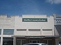
Shelby County Today is an on-line newspaper located across from the Shelby County Courthouse. It began operations in 2005

Among rural East Texas churches is the White Rock Missionary Baptist Church and Cemetery at 12555 Texas State Highway 7 near Center; pastor Keith Rose (2012)


Politics[]
See also[]
- National Register of Historic Places listings in Shelby County, Texas
- Recorded Texas Historic Landmarks in Shelby County
- Impact of the 2019–20 coronavirus pandemic on the meat industry in the United States
References[]
- ^ Jump up to: a b "State & County QuickFacts". United States Census Bureau. Retrieved December 24, 2013.
- ^ "Find a County". National Association of Counties. Retrieved 2011-06-07.
- ^ "Texas: Individual County Chronologies". Texas Atlas of Historical County Boundaries. The Newberry Library. 2008. Retrieved June 23, 2015.
- ^ "Shelby County". Texas Almanac. Texas State Historical Association. Retrieved June 23, 2015.
- ^ "2010 Census Gazetteer Files". United States Census Bureau. August 22, 2012. Retrieved May 10, 2015.
- ^ "Population and Housing Unit Estimates". United States Census Bureau. May 24, 2020. Retrieved May 27, 2020.
- ^ "U.S. Decennial Census". United States Census Bureau. Retrieved May 10, 2015.
- ^ "Texas Almanac: Population History of Counties from 1850–2010" (PDF). Texas Almanac. Retrieved May 10, 2015.
- ^ "U.S. Census website". United States Census Bureau. Retrieved 2011-05-14.
- ^ ""Archived copy". Archived from the original on 2012-08-15. Retrieved 2012-07-30.CS1 maint: archived copy as title (link)." Greyhound Lines. Retrieved on July 29, 2012. NOTE: The information for Center appears as a pop-up window.
- ^ JR., HARPER, CECIL (2010-06-15). "PATROON, TX". tshaonline.org. Retrieved 2018-07-30.
- ^ Leip, David. "Dave Leip's Atlas of U.S. Presidential Elections". uselectionatlas.org. Retrieved 2018-07-30.
External links[]
- Shelby County Sports
- Shelby County Today webpage
- Shelby County government's website
- Shelby County in Handbook of Texas Online at the University of Texas
- History of the regulators and moderators and the Shelby County war in 1841 and 1842, hosted by the Portal to Texas History
- Shelby County Chamber of Commerce website
- Shelby County Genealogy webpage (RootsWeb)
- Shelby County Community Links
| show Places adjacent to Shelby County, Texas |
|---|
| show Municipalities and communities of Shelby County, Texas, United States |
|---|


Coordinates: 31°47′N 94°08′W / 31.79°N 94.14°W
| show Authority control |
|---|
- Texas counties
- Shelby County, Texas
- 1836 establishments in the Republic of Texas
- Populated places established in 1836