Chinle Formation
| Chinle Formation Stratigraphic range: | |
|---|---|
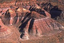 Chinle Badlands, Grand Staircase-Escalante National Monument, Utah, US. | |
| Type | Geological formation |
| Sub-units | Shinarump Conglomerate, Salitral Shale, , Bluewater Creek Member, Blue Mesa Member, Moss Back Member, Poleo Sandstone, Petrified Forest Member, Owl Rock Member, Rock Point Member, Church Rock Member |
| Underlies | Wingate Sandstone, Moenave Formation, Nugget Sandstone |
| Overlies | Moenkopi Formation or Cutler Group |
| Lithology | |
| Primary | fluvial mudstone, siltstone, and sandstone |
| Other | paleosols |
| Location | |
| Coordinates | 36°09′18″N 109°34′44″W / 36.155°N 109.579°W |
| Region | Colorado Plateau |
| Extent | Utah Colorado New Mexico Arizona Nevada |
| Type section | |
| Named for | Chinle, AZ |
| Named by | Herbert E. Gregory |
 Chinle Formation (the United States) | |


The Chinle Formation is an Upper Triassic continental geological formation of fluvial, lacustrine, and palustrine to eolian deposits spread across the U.S. states of Nevada, Utah, northern Arizona, western New Mexico, and western Colorado. The Chinle is controversially considered to be synonymous to the Dockum Group of eastern Colorado and New Mexico, western Texas, the Oklahoma panhandle, and southwestern Kansas. The Chinle is sometimes colloquially named as a formation within the Dockum Group in New Mexico and in Texas. The Chinle Formation is part of the Colorado Plateau, Basin and Range, and the southern section of the Interior Plains.[1]
A probable separate depositional basin within the Chinle is found in northwestern Colorado and northeastern Utah. The southern portion of the Chinle reaches a maximum thickness of a little over 520 meters (1,710 ft). Typically, the Chinle rests unconformably on the Moenkopi Formation.
History of investigation[]
There is no designated type locality for this formation. It was named for Chinle Valley in Apache County, Arizona by Herbert E. Gregory in 1917 without officially designating it as the formation's name until two years later and without a specified type locality.[2]
United States Geological Survey economic geologist in 1956 revised the unnamed members of Gregory by identifying and naming the Temple Mountain member as the basal-most unit in the area of the San Rafael Swell of Utah. In 1957 John H. Stewart revised the Shinarump Conglomerate of G. K. Gilbert, 1875, and Edwin E. Howell, 1875, and Gregory, 1917, and renamed it the Shinarump member of the Chinle formation. An overview of the geology of the area was created by USGS geologist Forrest G. Poole and Stewart in 1964. Steve W. Sikich revised the unit and assigned more members assigned in 1965.[3] The areal extent of the unit was mapped by R.F. Wilson and Stewart in 1967.[4] In 1972 the areal limits were modified and an overview created by Stewart and others (they published a revision the same year). V.C. Kelley assigned more members and revised the unit in 1972.[5] Spencer G. Lucas and S.N. Hayden did the same thing in 1989.[6] The Rock Point Member was assigned by R.F. Dubiel in 1989.[7]
The Chinle was raised to group rank by Lucas in 1993,[8] thus also raising many of the members to formation status. He also included the formations of the Dockum Group of eastern New Mexico and west Texas within the "Chinle Group". This modified nomenclature is controversial; many still retain the Chinle as a formation and separate out the Dockum Group.[9][10] The Dockum was named in 1890, before the Chinle. Lucas also advocated abandoning the name Dolores Formation as a parochial synonym for the Chinle Group.
Overviews of the Chinle were created by Dubiel and others (1992) and Hintze and Axen (1995).[11]
Stratigraphy[]
The formation members and their thicknesses are highly variable across the Chinle. The stratigraphically lowest formation is the Temple Mountain Member. However, in most areas, the basal member is the Shinarump Member.[12] The Shinarump is a braided-river system channel-deposit facies.[7] The Monitor Butte Member overlies the Shinarump in most areas. The Monitor Butte is an overbank (distal floodplain) facies with lacustrine deposits. This is overlain in western areas by the channel-deposit facies Moss Back Member. More commonly, the Monitor Butte grades into the Petrified Forest Member. The Petrified Forest is predominately overbank deposits with thin lenses of channel-deposit facies and lacustrine deposits.
The Petrified Forest Member can be divided into the Lower Petrified Forest Member and Upper Petrified Forest Member in Arizona and New Mexico, separated by the Sonsela Sandstone Bed. The Sonsela Sandstone is a braided-stream channel facies. The Petrified Forest grades into the Owl Rock Member. The Owl Rock is a marginal lacustrine to lacustrine facies possibly representing a large lake system. The upper Petrified Forest Member includes the thin but extensive Correo Sandstone Bed.[6] Finally, either the Rock Point Member or Church Rock Member overlie the Owl Rock. Some researchers feel the two Members may be synonymous.[13] The two Members are complex heterolithic units, representing variously braided-river facies, lacustrine, and overbank deposits.
In 2020, Lucas proposed the names Blue Mesa Member and Painted Desert Member for the lower and upper Petrified Forest members in west-central New Mexico, where he also raises the Chinle Formation to group rank.[14] He also assigns beds between the Shinarump Formation and the Petrified Forest Formation to the Bluewater Creek Formation.[6]
Ages of Chinle Members[]

The Chinle Formation is aged from early Late Triassic. Age correlation is based on Lucas's Land Vertebrate Faunachrons. The faunachrons are based on first and last appearances of phytosaurs. Simplified stratigraphy based on Litwin.[15]

| Sub-stage | Faunachron | Chinle Member(s) |
|---|---|---|
| Late Norian-Rhaetian | Apachean | Rock Point/Church Rock |
| Early to Middle Norian | Revueltian | Owl Rock
Upper Petrified Forest |
| upper Late Carnian | Adamanian | Sonsela Sandstone
Lower Petrified Forest Moss Back Monitor Butte |
| lower Late Carnian | Otischalkian | Shinarump
Temple Mountain |
Subunits[]


Asterisks (*) indicate usage by the U.S. Geological Survey. Other usages by state geological surveys.
Group rank (alphabetical – rank and formations not recognized by the USGS)[1]
- Bull Canyon Formation (NM)[16]
- Garita Creek Formation (NM)[16]
- Petrified Forest Formation (AZ, UT, NM)[17]
- Poleo Sandstone (NM)[17]
- Redonda Formation (NM)[16]
- Salitral Formation (NM*)[17]
- San Pedro Arroyo Formation (NM)[18][8]
- Santa Rosa Formation (NM)[19]
- Shinarump Formation (NM)[17]
- Trujillo Formation (NM)[16]
- Many others – see members below
Formation rank (alphabetical – several members not recognized by the USGS):[1]
- Agua Zarca Sandstone Member (NM);[20] now considered a junior synonym for the Shinarump Conglomerate.[17]
- Bluewater Creek Member (AZ, CO, NM)[6]
- Church Rock Member (AZ*, CO*, UT*); possibly equivalent to the Rock Point Member[21]
- Correo Sandstone Member or Bed (NM)[22]
- Cuervo Sandstone Member (NM); likely preempted by Trujillo Formation[23]
- Gartra Member (CO*, UT*)[3]
- Mesa Redondo Member (AZ*, NM*)[24]
- Monitor Butte Member (AZ*, CO*, UT*)[25][6]
- Moss Back Member (AZ*, CO*, UT*)[25]
- Owl Rock Member (AZ*, NM*, UT*)[25]
- Petrified Forest Member (AZ*, CO*, NV*, NM*, UT*)[25]
- Redonda Member (NM)[16]
- Rock Point Member (AZ*, NM*)[7]
- Shinarump Member (AZ*, NV*, NM*, UT*)[18]
- Stanaker Member (UT)[3]
- Temple Mountain Member (UT*)[26]
Places found[]

From top to bottom: (youngest to oldest)
5 – Rounded tan domes of the Navajo Sandstone,
4 – layered red Kayenta Formation,
3 – cliff-forming, vertically-jointed, red Wingate Sandstone,
2 – slope-forming, purplish Chinle Formation, layered, lighter-red Moenkopi Formation, and
1 – white, layered Cutler Formation sandstone.
Picture from Glen Canyon National Recreation Area, Utah
Geologic Province:[1]
- Rock Point Member
- Owl Rock Member
- Petrified Forest Member
- Mesa Redondo Member
- Shinarump Member
- Great Basin province*[27]
- Petrified Forest Member
- Shinarump Member
- Green River Basin*[28]
- upper member
- red siltstone member (possibly correlative with Church Rock Member)
- local sandstone and conglomerate member
- ochre siltstone member
- mottled member
- Gartra Member
- Redonda Formation
- Bull Canyon Formation
- Trujillo Formation
- Garita Creek Formation
- San Pedro Arroyo Formation
- Shinarump Formation
- * (undivided[29])
- Paradox Basin*[25]
- Church Rock Member
- Owl Rock Member
- Petrified Forest Member
- Moss Back Member
- Monitor Butte Member
- Shinarump Conglomerate
- Permian Basin (undivided[29])
- Piceance Basin*[28]
- upper member
- red siltstone member (possibly correlative with Church Rock Member)
- local sandstone and conglomerate member
- ochre siltstone member
- mottled member
- Gartra Member
- Rock Point Member
- Owl Rock Member
- Petrified Forest Member
- Mesa Redondo Member
- Shinarump Member
- Rock Point Formation
- Owl Rock Formation
- Petrified Forest Formation
- Bluewater Creek/San Pedro Arroyo Formations
- Shinarump Conglomerate/Zuni Mountains Formation
- * (undivided[29])
- Uinta Basin*[3]
- Stanaker Member
- Gartra Member
- Uinta Uplift*[3]
- Stanaker Member
- Gartra Member
- *[22]
Parklands:
- Arches National Park
- Canyonlands National Park – see geology of the Canyonlands area
- Capitol Reef National Park – see geology of the Capitol Reef area
- Colorado National Monument
- Dinosaur National Monument
- Flaming Gorge National Recreation Area
- Glen Canyon National Recreation Area
- Gold Butte National Monument
- Grand Canyon National Park – see geology of the Grand Canyon
- Grand Staircase-Escalante National Monument
- Lake Mead National Recreation Area
- Natural Bridges National Monument
- Petrified Forest National Park
- Red Fleet State Park
- Wupatki National Monument
- Zion National Park – see geology of the Zion and Kolob canyons area
- Red Rock Canyon National Conservation Area
Other:
See also[]
| Wikimedia Commons has media related to Chinle Formation. |
- List of dinosaur-bearing rock formations
- Paleobiota of the Chinle Formation
References[]
- ^ a b c d GEOLEX database entry for Chinle, USGS (viewed 19 March 2006)
- ^ Gregory, Herbert E. (1917). 1917; #164, with Raymond C. Moore, The Kaiparowits: A Geographic Reconnaissance of Parts of Utah and Arizona, 1931; #188, The San Juan. United States Geological Survey Professional Papers #93.
- ^ a b c d e Sikitch, Steve W. (1965). "Upper Triassic stratigraphy in the eastern Uinta Mountains". The Mountain Geologist. 2 (3): 167–172. Retrieved 30 October 2020.
- ^ Wilson, Richard F.; Stewart, John H. (1967). "Correlation of Upper Triassic and Triassic Formations between southwestern Utah and southern Nevada". U.S. Geological Survey Bulletin. 1244-D: D1–D20. doi:10.3133/b1244D.
- ^ Kelley, V.C. (1972). "Geology of the Fort Sumner sheet, New Mexico" (PDF). New Mexico Bureau of Mines and Mineral Resources Bulletin. 98. Retrieved 30 October 2020.
- ^ a b c d e Lucas, S.G.; Hayden, S.N. (1989). "Triassic stratigraphy of west-central New Mexico" (PDF). New Mexico Geological Society Field Conference Guidebook. 40: 191–211. Retrieved 30 October 2020.
- ^ a b c Dubiel, R.F. (1989). "Depositional and climatic setting of the Upper Triassic Chinle Formation, Colorado Plateau". In Lucas, S.G.; Hunt, A.P. (eds.). Dawn of the Age of Dinosaurs in the American Southwest. New Mexico Museum of Natural History. pp. 171–187. Retrieved 28 October 2021.
- ^ a b Lucas, S.G. (1993). "The Chinle Group: revised stratigraphy and biochronology of Upper Triassic Nonmarine strata in the western United States". Museum of Northern Arizona Bulletin. 59: 27–50.
- ^ a b Lehman, T.M. (1994). "The saga of the Dockum Group and the case of the Texas/New Mexico boundary fault" (PDF). New Mexico Bureau of Mines & Mineral Resources Bulletin. 150: 37–51. Retrieved 1 September 2020.
- ^ a b Cather, S.M.; Zeiger, Kate E.; Mack, Greg H.; Kelley, Shari A. (2013). "Toward standardization of Phanerozoic stratigraphic nomenclature in New Mexico". New Mexico Geological Society Spring Meeting: 12. CiteSeerX 10.1.1.667.3513. Retrieved 26 August 2020.
- ^ GEOLEX database bibliographic references for Chinle (viewed 19 March 2006)
- ^ "Shinarump Member of Chinle Formation". Colorado River Basin Stratigraphy. USGS. 6 May 2006. Retrieved 10 January 2011.
- ^ Milner, A.R. (2006). "Plant fossils from the Owl Rock or Church Rock Members, Chinle Formation, San Juan County, Utah". New Mexico Museum of Natural History and Science Bulletin. 37: 410–413. Retrieved 19 February 2022.
- ^ Lucas, Spencer G. (2020). "Triassic stratigraphy of the southeastern Colorado Plateau, west-central New Mexico" (PDF). New Mexico Geological Society Special Publication. 14: 123–133. Retrieved 30 October 2020.
- ^ Litwin, R.J., Traverse, A., and Ash, S.R., 1991. Preliminary palynological zonation of the Chinle Formation, southwestern U.S.A., and its correlation to the Newark Supergroup (eastern U.S.A.). Review of Paleobotany and Palynology, v. 77, pp. 269–287.
- ^ a b c d e f Lucas, S.G.; Hunt, A.P.; Huber, P. (1990). "Triassic stratigraphy in the Sangre de Cristo Mountains, New Mexico" (PDF). New Mexico Geological Society Field Conference Guidebook. 41: 305–318. Retrieved 12 November 2021.
- ^ a b c d e Lucas, Spencer G.; Zeigler, Kate E.; Heckert, Andrew B.; Hunt, Adrian P. (2005). "Review of Upper Triassic stratigraphy and biostratigraphy in the Chama Basin, northern New Mexico" (PDF). New Mexico Geological Society Field Conference Series. 56: 170–181. Retrieved 29 April 2020.
- ^ a b c Lucas, S.G. (1991). "Triassic stratigraphy, paleontology and correlation, south-central New Mexico" (PDF). New Mexico Geological Society Field Conference Guidebook. 42: 243–253. Retrieved 6 August 2020.
- ^ Finch, W.I.; Lupe, Robert; Ash, S.R. (1988). "Principal reference section for the Santa Rosa formation of Middle and Late Triassic age, Guadalupe County, New Mexico". U.S. Geological Survey Bulletin. 1804. doi:10.3133/b1804.
- ^ Wood, G.H.; Northrop, S.A. (1946). "Geology of the Nacimiento Mountains, San Pedro Mountain, and adjacent plateaus in parts of Sandoval and Rio Arriba Counties, New Mexico". USGS Oil and Gas Investigations. OM-57. doi:10.3133/om57. Retrieved 29 April 2020.
- ^ a b c Dubiel, R.F. (1989). "Sedimentology and revised nomenclature of the Upper Triassic Chinle Formation and the Lower Jurassic Wingate Sandstone, northwestern New Mexico and northeastern Arizona" (PDF). New Mexico Geological Society Field Conference Guidebook. 40: 213–223. Retrieved 12 November 2021.
- ^ a b Stewart, J.H.; Poole, F.G.; Wilson, R.F. (1972). "Stratigraphy and origin of the Chinle Formation and related Upper Triassic strata in the Colorado Plateau region, with sections on sedimentary petrology by R.A. Cadigan and conglomerate studies by William Thordarson and H.F. Albee". U.S. Geological Survey Professional Paper. 690. doi:10.3133/pp690.
- ^ Lucas, S.G.; Hunt, A.P. (1989). "Revised Triassic stratigraphy in the Tucumcari basin, east-central New Mexico". Dawn of the age of dinosaurs in the American southwest. New Mexico Museum of Natural History and Science. pp. 150–170. Retrieved 12 November 2021.
- ^ a b c Repenning, C.A.; Cooley, M.E.; Akers, J.P. (1969). "Stratigraphy of the Chinle and Moenkopi Formations, Navajo and Hopi Indian Reservations, Arizona, New Mexico, and Utah". U.S. Geological Survey Professional Paper. Professional Paper. 521-B: B1–B34. doi:10.3133/pp521B.
- ^ a b c d e Dubiel, R.F. (1987). "Sedimentology and new fossil occurrences of the Upper Triassic Chinle Formation, southeastern Utah". Four Corners Geological Society Field Conference Guidebook. 10: 99–107. Retrieved 12 November 2021.
- ^ O'Sullivan, R.B.; MacLachlan, M.E. (1975). "Triassic rocks of the Moab-White Canyon area, southeastern Utah". Four Corners Geological Society Field Conference Guidebook, 8th Field Conference (8): 129–141. Retrieved 12 November 2021.
- ^ Hintze, L.F.; Axen, G.J. (1995). "Geologic map of the Scarecrow Peak Quadrangle, Washington County, Utah, and Lincoln County, Nevada". U.S. Geological Survey Geologic Quadrangle Map. GQ-1759. Retrieved 16 November 2021.
- ^ a b Poole, F.G.; Stewart, J.H. (1964). "Chinle Formation and Glen Canyon Sandstone in northeastern Utah and northwestern Colorado". U.S. Geological Survey Professional Paper. 501-D: D30–D39. doi:10.3133/pp501D.
- ^ a b c Barnes, V.E., ed. (1983). "Tucumcari sheet". Geologic atlas of Texas. University of Texas-Austin, Bureau of Economic Geology.
- ^ Lucas, Spencer G. (2021). "Triassic stratigraphy of the southeastern Colorado Plateau, west-central New Mexico" (PDF). New Mexico Geological Society Field Conference Series. 72: 229–240. Retrieved 24 August 2021.
- ^ "Archived copy". Archived from the original on 1 April 2009. Retrieved 10 January 2011.
{{cite web}}: CS1 maint: archived copy as title (link)
Further reading[]
- Lucas, S.G. (1998). "Global Triassic tetrapod biostratigraphy and biochronology". Palaeogeography, Palaeoclimatology, and Palaeoecology, v. 143, pp. 347–384.
External links[]
- Chinle Formation
- Geologic formations of Nevada
- Triassic formations of New Mexico
- Triassic Colorado
- Geologic formations of Utah
- Triassic Arizona