South Wharf, Victoria
| South Wharf Melbourne, Victoria | |||||||||||||||
|---|---|---|---|---|---|---|---|---|---|---|---|---|---|---|---|
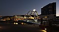
 View of South Wharf with the Seafarers Bridge in the foreground | |||||||||||||||
 South Wharf | |||||||||||||||
| Coordinates | 37°49′30″S 144°57′07″E / 37.825°S 144.952°ECoordinates: 37°49′30″S 144°57′07″E / 37.825°S 144.952°E | ||||||||||||||
| Population | 106 (2016 census)[1] | ||||||||||||||
| • Density | 424/km2 (1,098/sq mi) | ||||||||||||||
| Established | 2008 | ||||||||||||||
| Postcode(s) | 3006 | ||||||||||||||
| Area | 0.25 km2 (0.1 sq mi) | ||||||||||||||
| Location | 2 km (1 mi) from Melbourne | ||||||||||||||
| LGA(s) | |||||||||||||||
| State electorate(s) | Albert Park | ||||||||||||||
| Federal Division(s) | Macnamara | ||||||||||||||
| |||||||||||||||

South Wharf is an inner suburb of Melbourne, Victoria, Australia, 2 km south-west of Melbourne's Central Business District. Its local government areas are the Cities of Melbourne and Port Phillip. At the 2016 Census, South Wharf had a population of 106.[1]
South Wharf is a small inner suburb south west from Melbourne's CBD.[2] Its borders are the Yarra River to the north, Wurundjeri Way to the west, the West Gate Freeway and a small private car park bordering Ford Street and Munro Street, which is part of the City of Port Phillip, to the south and the former Port Melbourne railway line and Clarendon Street to the east.
Gazetted in 2008 [3] and formerly part of the industrial and shipping area of Southbank, the renaming is part of a wider urban renewal strategy to link Southbank with the Melbourne Docklands.
South Wharf includes some of Melbourne's landmarks, including the Melbourne Exhibition and Convention Centre and the Melbourne Maritime Museum, with its heritage Polly Woodside.
South Wharf is also home to many apartments, shopping outlet Direct Factory Outlets and the 5-star luxury hotel
A five-storey Victorian warehouse, known as the Tea House (at 28 Clarendon Street), built in 1888, is one of the few buildings which survived the redevelopment of the area.
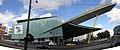
Melbourne Exhibition Centre

The Polly Woodside

Night view of Seafarers Bridge at South Wharf
South Wharf and the Melbourne Convention and Exhibition Centre

Looking towards South Wharf from the Rialto Towers observation deck


References[]
- ^ Jump up to: a b "2016 Census QuickStats South Wharf". Australian Bureau of Statistics. Retrieved 7 September 2018.
- ^ "Archived copy" (PDF). Archived from the original (PDF) on 30 March 2012. Retrieved 7 December 2011.CS1 maint: archived copy as title (link)
- ^ "Victoria Government Gazette No. G2 Thursday 10 January 2008" (PDF). p. 72. Retrieved 28 August 2008.
External links[]
| Wikimedia Commons has media related to South Wharf, Victoria. |
| Authority control |
|
|---|
- Suburbs of Melbourne
- Port of Melbourne