St. Joseph County, Indiana
Saint Joseph County | |
|---|---|
U.S. county | |
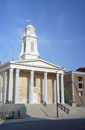 Old St. Joseph County courthouse in South Bend, Indiana | |
 Flag  Seal | |
 Location within the U.S. state of Indiana | |
 Indiana's location within the U.S. | |
| Coordinates: 41°37′N 86°17′W / 41.62°N 86.29°W | |
| Country | |
| State | |
| Founded | 1830 |
| Named for | St. Joseph River |
| Seat | South Bend |
| Largest city | South Bend |
| Area | |
| • Total | 461.38 sq mi (1,195.0 km2) |
| • Land | 457.85 sq mi (1,185.8 km2) |
| • Water | 3.54 sq mi (9.2 km2) 0.77%% |
| Population | |
| • Estimate (2019) | 271,826 |
| • Density | 580/sq mi (224/km2) |
| Time zone | UTC−5 (Eastern) |
| • Summer (DST) | UTC−4 (EDT) |
| Congressional district | 2nd |
| Website | www |
| |

St. Joseph County, commonly called St. Joe County by locals, is a county located in the U.S. state of Indiana. As of Census 2010, the population was 266,931,[1] making it the fifth-most populous county in Indiana. Formed in 1830, it was named for the St. Joseph River which flows through it to Lake Michigan. The county seat is South Bend.[2] St. Joseph County is part of the South Bend–Mishawaka, IN-MI, Metropolitan Statistical Area.
Geography[]
According to the 2010 census, the county has a total area of 461.38 square miles (1,195.0 km2), of which 457.85 square miles (1,185.8 km2) (or 99.23%) is land and 3.54 square miles (9.2 km2) (or 0.77%) is water.[3]
Cities[]

- Mishawaka
- South Bend
Towns[]
Census-designated places[]
Other unincorporated places[]
Townships[]
Adjacent counties[]
- Berrien County, Michigan (north)
- Cass County, Michigan (northeast)
- Elkhart County (east)
- Marshall County (south)
- Starke County (southwest/CST Border)
- LaPorte County (west/CST Border)
Major highways[]
Climate and weather[]
| South Bend, Indiana | ||||||||||||||||||||||||||||||||||||||||||||||||||||||||||||
|---|---|---|---|---|---|---|---|---|---|---|---|---|---|---|---|---|---|---|---|---|---|---|---|---|---|---|---|---|---|---|---|---|---|---|---|---|---|---|---|---|---|---|---|---|---|---|---|---|---|---|---|---|---|---|---|---|---|---|---|---|
| Climate chart (explanation) | ||||||||||||||||||||||||||||||||||||||||||||||||||||||||||||
| ||||||||||||||||||||||||||||||||||||||||||||||||||||||||||||
| ||||||||||||||||||||||||||||||||||||||||||||||||||||||||||||
In recent years, average temperatures in South Bend have ranged from a low of 16 °F (−9 °C) in January to a high of 83 °F (28 °C) in July, although a record low of −22 °F (−30 °C) was recorded in January 1943 and a record high of 109 °F (43 °C) was recorded in July 1934. Average monthly precipitation ranged from 1.98 inches (50 mm) in February to 4.19 inches (106 mm) in June.[4]
Government[]
The county government is a constitutional body, and is granted specific powers by the Constitution of Indiana, and by the Indiana Code.
County Council: The county council is the legislative branch of the county government and controls all the spending and revenue collection in the county. Representatives are elected from county districts. The council members serve four-year terms. They are responsible for setting salaries, the annual budget, and special spending. The council also has limited authority to impose local taxes, in the form of an income and property tax that is subject to state level approval, excise taxes, and service taxes.[5][6]
| District | Councilperson | Party |
|---|---|---|
| A | Bobby Kruszynski, Jr. | Democratic |
| B | Corey Noland | Democratic |
| C | Dick Pfeil | Republican |
| D | Rafael Morton, President | Democratic |
| E | Diana Hess | Democratic |
| F | Mark Telloyan | Republican |
| G | Mark Catanzarite, Vice President pro tem | Democratic |
| H | Joe Canarecci | Democratic |
| I | Mark Root, President pro tem | Republican |
Board of Commissioners: The executive body of the county is made of a board of commissioners. The commissioners are elected county-wide, in staggered terms, and each serves a four-year term. One of the commissioners, typically the most senior, serves as president. The commissioners are charged with executing the acts legislated by the council, collecting revenue, and managing the day-to-day functions of the county government.[5][6]
| District | Commissioner | Party |
|---|---|---|
| 1 | Andrew Kostielney, President | Republican |
| 2 | Dave Thomas, Vice President | Democratic |
| 3 | Deborah Fleming | Republican |
Court: The county maintains several courts: the Circuit Court that hears primarily civil matters and some criminal cases. The judge on the court is elected to a term of six years and must be a licensed attorney in good standing. The judge is assisted by three magistrates appointed by the judge. The Superior Court hears both civil and criminal cases, including small claims and traffic/misdemeanor cases. There are eight judges appointed to the Superior Court by the Governor of Indiana. They are assisted by four magistrates who handle the small claims and traffic/misdemeanor dockets. The Probate Court hears juvenile cases, child abuse or neglect cases, along with probate matters. The judge on the court is elected to a term of six years and must be a licensed attorney in good standing. The judge is assisted by three magistrates and one commissioner (similar to a magistrate) who are appointed by the judge. Decisions from these courts can be appealed to the Indiana Court of Appeals.[6]
| Office | Judge | Party |
|---|---|---|
| Circuit Court | John Broden | Democratic |
County Officials: The county has several other elected offices, including sheriff, coroner, auditor, treasurer, recorder, surveyor, and circuit court clerk. Each of these elected officers serves a term of four years and oversees a different part of county government. Members elected to county government positions are required to declare party affiliations and to be residents of the county.[6]
| Office | Officeholder | Party |
|---|---|---|
| Assessor | Rosemary Mandrici | Democratic |
| Auditor | Mike Hamann | Democratic |
| Clerk | Rita Glenn | Democratic |
| Coroner | Michael J. McGann | Democratic |
| Prosecutor | Ken Cotter | Democratic |
| Recorder | Phil Dotson | Democratic |
| Sheriff | William Redman | Democratic |
| Surveyor | John McNamara | Democratic |
| Treasurer | Michael Kruk | Democratic |
St. Joseph County is part of Indiana's 2nd congressional district and is represented by Jackie Walorski in the United States Congress.[7] Indiana's US Senators are Mike Braun and Todd Young.
Demographics[]
| Historical population | |||
|---|---|---|---|
| Census | Pop. | %± | |
| 1830 | 287 | — | |
| 1840 | 6,425 | 2,138.7% | |
| 1850 | 10,954 | 70.5% | |
| 1860 | 18,455 | 68.5% | |
| 1870 | 25,322 | 37.2% | |
| 1880 | 33,178 | 31.0% | |
| 1890 | 42,457 | 28.0% | |
| 1900 | 58,881 | 38.7% | |
| 1910 | 84,312 | 43.2% | |
| 1920 | 103,304 | 22.5% | |
| 1930 | 160,033 | 54.9% | |
| 1940 | 161,823 | 1.1% | |
| 1950 | 205,058 | 26.7% | |
| 1960 | 238,614 | 16.4% | |
| 1970 | 245,045 | 2.7% | |
| 1980 | 241,617 | −1.4% | |
| 1990 | 247,052 | 2.2% | |
| 2000 | 265,559 | 7.5% | |
| 2010 | 266,931 | 0.5% | |
| 2019 (est.) | 271,826 | [10] | 1.8% |
| U.S. Decennial Census[11] 1790-1960[12] 1900-1990[13] 1990-2000[14] 2010-2019[1] | |||
As of the 2010 United States Census, there were 266,931 people, 103,069 households, and 66,365 families residing in the county.[15] The population density was 583.0 inhabitants per square mile (225.1/km2). There were 114,849 housing units at an average density of 250.8 per square mile (96.8/km2).[3] The racial makeup of the county was 78.7% white, 12.7% black or African American, 1.9% Asian, 0.4% American Indian, 0.1% Pacific islander, 3.4% from other races, and 2.9% from two or more races. Those of Hispanic or Latino origin made up 7.3% of the population.[15] In terms of ancestry, 25.3% were German, 15.5% were Irish, 12.0% were Polish, 8.5% were English, and 4.5% were American.[16]
Of the 103,069 households, 32.2% had children under the age of 18 living with them, 46.1% were married couples living together, 13.6% had a female householder with no husband present, 35.6% were non-families, and 29.1% of all households were made up of individuals. The average household size was 2.48 and the average family size was 3.07. The median age was 36.2 years.[15]
The median income for a household in the county was $47,697 and the median income for a family was $57,510. Males had a median income of $45,269 versus $31,667 for females. The per capita income for the county was $23,082. About 10.7% of families and 14.6% of the population were below the poverty line, including 21.7% of those under age 18 and 7.8% of those age 65 or over.[17]
Education[]
School districts[]
John Glenn School Corporation[]
- North Liberty Elementary
- Walkerton Elementary
- Urey Middle School
- John Glenn High School
New Prairie United School Corporation[]
- Olive Township Elementary
- New Prairie Middle School
- New Prairie High School
Penn-Harris-Madison School Corporation[]
- Bittersweet Elementary
- Elm Road Elementary
- Elise Rogers Elementary
- Horizon Elementary
- Madison Elementary
- Mary Frank Elementary
- Meadow's Edge Elementary
- Moran Elementary
- Northpoint Elementary
- Prairie Vista Elementary
- Walt Disney Elementary
- Discovery Middle School
- Grissom Middle School
- Schmucker Middle School
- Penn High School
School City of Mishawaka[]
- Battell Elementary
- Beiger Elementary
- Emmons Elementary
- Hums Elementary
- LaSalle Elementary
- Liberty Elementary
- Twin Branch Elementary
- John Young Middle School
- Mishawaka High School
- Bingham Elementary School (closed)
South Bend Community School Corporation[]
High schools[]
- John Adams High School Bird's Eye
- Clay High School Bird's Eye
- James Whitcomb Riley High School Bird's Eye
- Washington High School Bird's Eye
Middle Schools[]
- Brown Intermediate Center Bird's Eye
- Clay Intermediate Center Bird's Eye
- Dickinson Intermediate Center Bird's Eye
- Edison Intermediate Center Bird's Eye
- Jackson Intermediate Center Bird's Eye
- Jefferson Intermediate Center Bird's Eye
- Lasalle Intermediate Academy Bird's Eye
- Navarre Intermediate Center Bird's Eye
Elementary Schools[]
- Coquillard Primary Center Bird's Eye
- Darden Primary Center Bird's Eye
- Harrison Primary Center Bird's Eye
- Hay Primary Center Bird's Eye
- Kennedy Academy Bird's Eye
- Lafayette Early Childhood Center Bird's Eye
- Lincoln Primary Center Bird's Eye
- Madison Primary Center Bird's Eye
- Marshall Traditional School Bird's Eye
- Marquette Primary Center Bird's Eye
- McKinley Primary Center Bird's Eye
- Monroe Primary Center Bird's Eye
- Muessel Primary Center Bird's Eye
- Nuner Primary Center Bird's Eye
- Perley Primary Center Bird's Eye
- Swanson Primary Center Bird's Eye
- Tarkington Traditional Primary Center Bird's Eye
- Warren Primary Center Bird's Eye
- Wilson Primary Center Bird's Eye
Union-North United School Corporation[]
- LaVille Elementary
- LaVille Junior-Senior High School
Private Schools[]
- Christ the King [Grades K-8]
- Corpus Christi [Grades K-8]
- Covenant Christian School [Grades K-8]
- Granger Christian School [Grades K-12]
- Holy Cross Elementary [Grades K-8]
- Holy Family Elementary [Grades K-8]
- Ironwood Christian School [Grades K-12]
- Mishawaka Catholic School (St. Bavo Campus, St. Joseph Campus & St. Monica Campus) [Grades ECD-8]
- Michiana Christian School [Grades K-5]
- Mishawaka First Baptist School [Grades K-12]
- Marian High School [Grades 9-12]
- North Liberty Christian School [Grades K-5]
- Our Lady of Hungary [Grades K-8]
- Queen of Peace School [Grades K-6]
- Resurrection Lutheran Academy [Grades Pre K-8]
- St. Adalbert Elementary [Grades K-8]
- St. Anthony de Padua School [Grades K-8]
- St. John the Baptist Elementary [Grades K-8]
- St. Joseph Grade School [Grades K-8]
- St. Jude Elementary [Grades K-8]
- St. Mary of the Assumption School [Grades K-8]
- St. Matthew Elementary [Grades K-8]*St. Patrick School [Grades K-6]
- St. Pius X School [Grades Pre K-8]
- South Bend Christian Center [Grades K-12]
- South Bend Junior Academy [Grades K-8]
- South Bend St. Joseph's High School [Grades 9-12]
- South Bend Trinity School [Grades 7-12]
- Stanley Clark School [Grades K-8]
- Trinity School at Greenlawn [Grades 6-12]
Colleges & universities[]
- Bethel College
- Brown Mackie College
- Holy Cross College
- Ivy Tech North Central
- Indiana University South Bend
- St. Mary's College
- University of Notre Dame
St. Joseph County Public Library[]
History[]
The St. Joseph County Public Library was founded in 1889. Originally known as the South Bend Public Library, it was founded by the South Bend School Corporation and managed by Evelyn Humphries out of a floor of the Oliver Opera House. Humphries soon secured funding for the building of the Main Library which opened to the public in 1896. It was known as "The Castle" due to its unique architecture.[18] In 1902, Virginia Tutt became the second library director. She opened the first library branch in Washington High School in 1918, which often served as a community center for Polish and Hungarian immigrants. The Betty Ruth Spiro Memorial Library replaced "The Castle" in 1959 as the new main library building in downtown South Bend. This building served the community until its renovation in 1992 led to a fire and subsequent damage from smoke and fire sprinklers. The renovation continued and the library was able to open 7 days later thanks to help from the community.[19] In 2016, Main Library began looking at the need for an expanded space in downtown South Bend to meet the needs of the growing community. After working with consultants and architects, it was decided in October 2018 that Main Library will expand to include a community learning center, renovated exterior, and inner courtyard.[20] St. Joseph County is considering cutting the library's funding by almost $500,000 a year. As a result, on September 5, 2019, hundreds of residents protested in the streets, and all library branches closed early. Overflow crowds backed the county council meeting to show their support for the library.[21]
Branches[]
- Main Library
- Centre Township Branch
- Francis Branch
- German Township Branch
- Lakeville Branch
- LaSalle Branch
- North Liberty Branch
- River Park Branch
- Tutt Branch
- Western Branch
Library Services[]
Studio 304[]
Technology hub where patrons can explore 3-D printing, poster printing, iPads, Adobe Creative Suite, gaming, virtual reality rigs, and recording rooms.[22]
Local and Family History[]
Books, newspapers, yearbooks, magazines, and other items of local significance can be examined. Online archives and genealogical websites are also available to reference in the creation of family trees.[23]
Databases[]
SJCPL subscribes to over 50 databases that can aid in research, education, grant writing, and business development.[24]
Homebound Delivery[]
Library staff members will bring library materials directly to your home if requested.[25]
See also[]
- List of public art in St. Joseph County, Indiana
- National Register of Historic Places listings in St. Joseph County, Indiana
References[]
- ^ Jump up to: a b "St. Joseph County QuickFacts". United States Census Bureau. Retrieved September 25, 2011.
- ^ "Find a County". National Association of Counties. Retrieved 2011-06-07.
- ^ Jump up to: a b "Population, Housing Units, Area, and Density: 2010 - County". United States Census Bureau. Archived from the original on 2020-02-13. Retrieved 2015-07-10.
- ^ Jump up to: a b "Monthly Averages for South Bend, Indiana". The Weather Channel. Retrieved 2011-01-27.
- ^ Jump up to: a b Indiana Code. "Title 36, Article 2, Section 3". IN.gov. Retrieved 2008-09-16.
- ^ Jump up to: a b c d Indiana Code. "Title 2, Article 10, Section 2" (PDF). IN.gov. Retrieved 2008-09-16.
- ^ "US Congresswoman Jackie Walorski". US Congress. Retrieved 2013-06-05.
- ^ Leip, David. "Dave Leip's Atlas of U.S. Presidential Elections". uselectionatlas.org. Retrieved 2018-05-20.
- ^ The leading "other" candidate, Progressive Theodore Roosevelt, received 5,240 votes, while Socialist candidate Eugene Debs received 1,285 votes, Prohibition candidate Eugene Chafin received 452 votes, and Socialist Labor candidate Arthur Reimer received 87 votes.
- ^ "Population and Housing Unit Estimates". Retrieved March 26, 2020.
- ^ "U.S. Decennial Census". United States Census Bureau. Retrieved July 10, 2014.
- ^ "Historical Census Browser". University of Virginia Library. Retrieved July 10, 2014.
- ^ "Population of Counties by Decennial Census: 1900 to 1990". United States Census Bureau. Retrieved July 10, 2014.
- ^ "Census 2000 PHC-T-4. Ranking Tables for Counties: 1990 and 2000" (PDF). United States Census Bureau. Retrieved July 10, 2014.
- ^ Jump up to: a b c "DP-1 Profile of General Population and Housing Characteristics: 2010 Demographic Profile Data". United States Census Bureau. Archived from the original on 2020-02-13. Retrieved 2015-07-10.
- ^ "DP02 SELECTED SOCIAL CHARACTERISTICS IN THE UNITED STATES – 2006-2010 American Community Survey 5-Year Estimates". United States Census Bureau. Archived from the original on 2020-02-14. Retrieved 2015-07-10.
- ^ "DP03 SELECTED ECONOMIC CHARACTERISTICS – 2006-2010 American Community Survey 5-Year Estimates". United States Census Bureau. Archived from the original on 2020-02-14. Retrieved 2015-07-10.
- ^ "Library History". . Retrieved 2018-11-25.
- ^ "Our History". Saint Joseph County Public Library. Retrieved 26 November 2018.
- ^ Parrott, Jeff. "Downtown South Bend library proposes dramatic, $38-million overhaul". South Bend Tribune. Retrieved 26 November 2018.
- ^ "St. Joseph Co. libraries close early in protest of plan to cut funding by close to $500k". WSBT News. 5 September 2019. Retrieved 10 September 2019.
- ^ "Studio 304 Digital Media Lab". St. Joseph County Public Library. Retrieved 26 November 2018.
- ^ "Local and Family History". St. Joseph County Public Library. Retrieved 26 November 2018.
- ^ "Database and Articles". St. Joseph County Public Library. Retrieved 26 November 2018.
- ^ "Homebound Services". St. Joseph County Public Library. Retrieved 26 November 2018.
External links[]
| show Places adjacent to St. Joseph County, Indiana |
|---|
| show Municipalities and communities of St. Joseph County, Indiana, United States |
|---|

Coordinates: 41°37′N 86°17′W / 41.62°N 86.29°W
| show Authority control |
|---|
- Indiana counties
- St. Joseph County, Indiana
- 1830 establishments in Indiana
- Populated places established in 1830
- South Bend – Mishawaka metropolitan area