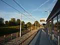
St Werburgh's Road tram stop
St Werburgh's Road | |||||||||||||||||||||||||||||||||||||||||||||||||||||||||||||||||||||||||||||||||||||||||||||||||||||||||||||||||||||||||||||||||||||||||||||
|---|---|---|---|---|---|---|---|---|---|---|---|---|---|---|---|---|---|---|---|---|---|---|---|---|---|---|---|---|---|---|---|---|---|---|---|---|---|---|---|---|---|---|---|---|---|---|---|---|---|---|---|---|---|---|---|---|---|---|---|---|---|---|---|---|---|---|---|---|---|---|---|---|---|---|---|---|---|---|---|---|---|---|---|---|---|---|---|---|---|---|---|---|---|---|---|---|---|---|---|---|---|---|---|---|---|---|---|---|---|---|---|---|---|---|---|---|---|---|---|---|---|---|---|---|---|---|---|---|---|---|---|---|---|---|---|---|---|---|---|---|---|
| Metrolink station | |||||||||||||||||||||||||||||||||||||||||||||||||||||||||||||||||||||||||||||||||||||||||||||||||||||||||||||||||||||||||||||||||||||||||||||
 The stop shortly after opening | |||||||||||||||||||||||||||||||||||||||||||||||||||||||||||||||||||||||||||||||||||||||||||||||||||||||||||||||||||||||||||||||||||||||||||||
| Location | Chorlton-cum-Hardy, Manchester England | ||||||||||||||||||||||||||||||||||||||||||||||||||||||||||||||||||||||||||||||||||||||||||||||||||||||||||||||||||||||||||||||||||||||||||||
| Coordinates | 53°26′19″N 2°15′55″W / 53.4387°N 2.2654°WCoordinates: 53°26′19″N 2°15′55″W / 53.4387°N 2.2654°W | ||||||||||||||||||||||||||||||||||||||||||||||||||||||||||||||||||||||||||||||||||||||||||||||||||||||||||||||||||||||||||||||||||||||||||||
| Grid reference | SJ824936 | ||||||||||||||||||||||||||||||||||||||||||||||||||||||||||||||||||||||||||||||||||||||||||||||||||||||||||||||||||||||||||||||||||||||||||||
| Line(s) | South Manchester Line | ||||||||||||||||||||||||||||||||||||||||||||||||||||||||||||||||||||||||||||||||||||||||||||||||||||||||||||||||||||||||||||||||||||||||||||
| Platforms | 2 (island) | ||||||||||||||||||||||||||||||||||||||||||||||||||||||||||||||||||||||||||||||||||||||||||||||||||||||||||||||||||||||||||||||||||||||||||||
| Other information | |||||||||||||||||||||||||||||||||||||||||||||||||||||||||||||||||||||||||||||||||||||||||||||||||||||||||||||||||||||||||||||||||||||||||||||
| Status | In operation | ||||||||||||||||||||||||||||||||||||||||||||||||||||||||||||||||||||||||||||||||||||||||||||||||||||||||||||||||||||||||||||||||||||||||||||
| Fare zone | 2/3 | ||||||||||||||||||||||||||||||||||||||||||||||||||||||||||||||||||||||||||||||||||||||||||||||||||||||||||||||||||||||||||||||||||||||||||||
| History | |||||||||||||||||||||||||||||||||||||||||||||||||||||||||||||||||||||||||||||||||||||||||||||||||||||||||||||||||||||||||||||||||||||||||||||
| Opened | 7 July 2011 | ||||||||||||||||||||||||||||||||||||||||||||||||||||||||||||||||||||||||||||||||||||||||||||||||||||||||||||||||||||||||||||||||||||||||||||
| Original company | Manchester Metrolink | ||||||||||||||||||||||||||||||||||||||||||||||||||||||||||||||||||||||||||||||||||||||||||||||||||||||||||||||||||||||||||||||||||||||||||||
| |||||||||||||||||||||||||||||||||||||||||||||||||||||||||||||||||||||||||||||||||||||||||||||||||||||||||||||||||||||||||||||||||||||||||||||
| Location | |||||||||||||||||||||||||||||||||||||||||||||||||||||||||||||||||||||||||||||||||||||||||||||||||||||||||||||||||||||||||||||||||||||||||||||
 St Werburgh's Road Location within Manchester_Metrolink | |||||||||||||||||||||||||||||||||||||||||||||||||||||||||||||||||||||||||||||||||||||||||||||||||||||||||||||||||||||||||||||||||||||||||||||

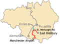
St Werburgh's Road is a tram stop on the South Manchester Line (SML) and Airport Line of Greater Manchester's light-rail Metrolink system in Chorlton-cum-Hardy, Manchester. It was built as part of Phase 3a of the network's expansion and opened on 7 July 2011.[1]
Consisting of an island platform to the east of St Werburgh's Road, the stop is built largely on the site of the former Chorlton Junction Signal Box and its surroundings. It serves as an interchange for passengers travelling towards either Manchester Airport or East Didsbury.
History[]
St Werburgh's Road stop is on a re-opened railway line, the Cheshire Lines Committee line, which closed to passenger service in 1967. It was planned to reopen the line as part of the expansion of the Manchester Metrolink tram network.[2] Proposals to re-open the line have been put forward since the 1980s,[3] but remained unfunded until the 2000s. The line extension which was originally proposed would take over the disused trackbed of the Cheshire Lines Committee as far as East Didsbury.
In 2006, it was announced that the first phase of the "Big Bang" Metrolink expansion project (Phase 3A) would go ahead, including extending the network as far as St Werburgh's Road.[4] Following the rejection of the Greater Manchester Transport Innovation Fund in a public referendum in 2008, extension of the line to East Didsbury (Phase 3B) went ahead with funding from national and local government.[2][5][6]
Construction of the line began in April 2009 and the line became operational as far as St Werburgh's Road in July 2011.[1] Services to East Didsbury became operational on 23 May 2013.[7]
On 3 November 2014, the Metrolink extension was opened from St Werburgh's Road station to Manchester Airport station.
In July 2015, a tram derailed at the stop after vandals attacked the tram and the tracks.[8] In July 2016, a man was badly injured at the stop when his leg became trapped between a tram and the platform.[9]
Service pattern[]
- 12 minute service to Shaw and Crompton, with double trams at peak times;
- 12 minute service to Rochdale Town Centre, with double trams at peak times;
- 12 minute service to Victoria, with single trams (every 20 minutes before 6 am);
- 6 minute service to East Didsbury, with double trams at peak times;
- 12 minute service to Manchester Airport, with single trams (every 20 minutes before 6 am).
Connecting bus routes[]
St Werburgh's Road station is served by the 84A bus route, running from Davyhulme to Merseybank via Urmston, Stretford and Chorlton. There are several services that stop in nearby Chorlton centre.[10]
Cycle track[]
The Fallowfield Loop cycle path begins at St Werburgh's Road station and follows the old trackbed of the former Fallowfield Loop railway line through Fallowfield and Levenshulme to Debdale Park.[11]
Gallery[]

1914 map of South Manchester railways

Construction work on the line near Chorlton
Map of the planned South Manchester line extensions
The cycle track (left) continues along the former Fallowfield Loop line


References[]
- ^ a b "Metrolink's new Chorlton line opens for business". Transport for Greater Manchester. Archived from the original on 17 July 2011. Retrieved 6 July 2011.
- ^ a b Linton, Deborah (13 May 2009). "£1.4bn transport deal unveiled". Manchester Evening News. Retrieved 17 May 2009.
- ^ Greater Manchester Passenger Transport Executive (1984), Light Rapid Transit in Greater Manchester, GMPTE - publicity brochure
- ^ "Metrolink extension is announced". BBC News. 6 July 2006. Retrieved 28 December 2008.
- ^ "Tram line extension is approved". BBC News. 13 May 2009. Retrieved 17 May 2009.
- ^ "Metrolink: back on track?". BBC Manchester. 13 May 2009. Retrieved 17 May 2009.
- ^ Kirby, Dean (13 May 2013). "Metrolink extension to East Didsbury to open next week- three months early". Retrieved 21 July 2016.
- ^ Abbit, Beth (4 July 2015). "Metrolink tram derails in Chorlton due to vandalism on the line - live updates". Retrieved 21 July 2016.
- ^ Rucki, Alexandra (21 July 2016). "Man suffers serious injuries after leg is trapped between tram and platform". Retrieved 21 July 2016.
- ^ "Public Transport Network Map - South Manchester" (PDF). TfGM. Retrieved 8 April 2020.
- ^ "Friends of the Fallowfield Loop". Retrieved 14 March 2013.
External links[]
| Wikimedia Commons has media related to St Werburgh's Road Metrolink station. |
- Metrolink stop information
- St Werburgh's Road area map
- Manchester Metrolink Extension Project - map of the plans (Urban Transport Technology)
- https://web.archive.org/web/20130226053951/http://www.lrta.org/Manchester/city_south.html
| Tram stops |   | ||||||||
|---|---|---|---|---|---|---|---|---|---|
| Operations |
| ||||||||
| History (Timeline) |
| ||||||||
| Proposed developments |
| ||||||||
| |||||||||
- Tram stops in Manchester
- Manchester South District Line
- Railway stations in Great Britain opened in 2011
- Tram stops on the East Didsbury to Rochdale line
- 2011 establishments in England