Topton, North Carolina
Topton, North Carolina | |
|---|---|
Unincorporated community | |
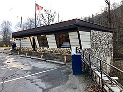 The U.S. Post Office at Topton | |
 Topton | |
| Coordinates: 35°14′49″N 83°42′12″W / 35.24694°N 83.70333°WCoordinates: 35°14′49″N 83°42′12″W / 35.24694°N 83.70333°W | |
| Country | United States |
| State | North Carolina |
| County | Cherokee |
| Elevation | 2,654 ft (809 m) |
| Time zone | UTC-5 (Eastern (EST)) |
| • Summer (DST) | UTC-4 (EDT) |
| ZIP code | 28781 |
| Area code(s) | 828 |
| GNIS feature ID | 1022969[1] |


Topton is an unincorporated community in Cherokee County, North Carolina, United States. Topton is located on U.S. Route 19, U.S. Route 74, and U.S. Route 129, 7.5 miles (12.1 km) east-northeast of Andrews. Topton has a post office with ZIP code 28781.[2][3]
References[]
- ^ "Topton". Geographic Names Information System. United States Geological Survey.
- ^ United States Postal Service (2012). "USPS - Look Up a ZIP Code". Retrieved 2012-02-15.
- ^ "Postmaster Finder - Post Offices by ZIP Code". United States Postal Service. Retrieved March 11, 2013.
Municipalities and communities of Cherokee County, North Carolina, United States | ||
|---|---|---|
| Towns | 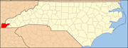 | |
| CDP | ||
| Other communities | ||
| Indian reservation | ||
| Footnotes | ‡This populated place also has portions in an adjacent county or counties | |
| ||
Categories:
- Unincorporated communities in Cherokee County, North Carolina
- Unincorporated communities in North Carolina
- Western North Carolina geography stubs