Tornado outbreak of March 28–31, 2007
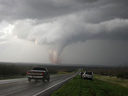 A tornado near Turkey, Texas on March 28, 2007 | |
| Type | Tornado outbreak |
|---|---|
| Duration | March 28–31, 2007 |
| Highest winds |
|
| Tornadoes confirmed | 80 confirmed |
| Max. rating1 | EF3 tornado |
| Duration of tornado outbreak2 | 3 days, 4 hours |
| Largest hail | Softball size |
| Fatalities | 5 fatalities, 26 injuries |
| Damage | $15.1 million[1] |
| Areas affected | Great Plains, Central United States |
| 1Most severe tornado damage; see Enhanced Fujita scale 2Time from first tornado to last tornado | |
The tornado outbreak of March 28–31, 2007, also known as the Late-March 2007 tornado outbreak, was a tornado outbreak that took place across the central United States. It developed in the High Plains from South Dakota to central Texas on March 28, 2007, which produced most of the tornadoes. Several more tornadoes were reported the next three days before the system weakened on March 31. It affected western Nebraska, western Kansas, extreme eastern Colorado, and much of Oklahoma, and Texas. It was the second major outbreak of 2007, four weeks after an outbreak farther east. The outbreak produced 80 confirmed tornadoes, with five deaths and extensive damage being reported. In addition to the tornadoes, widespread hail as large as softballs and destructive straight-line winds as strong as 90 mph (140 km/h) were reported.
The activity level was very uncertain for March 29, as it was conditional on the dry line refiring. Despite the squall line remaining intact, several more tornadoes developed. Several more tornadoes developed on March 30 and 31 before the system weakened.
Meteorological synopsis[]
A powerful mid and upper level system brought terrifically strong wind fields aloft over the southern and central portions of the Great Plains region on March 28. This system was located over the Great Basin and tracked eastward into the central Rocky Mountains during this time frame. Ahead of the system, a dry line developed from a low-pressure area over extreme northeastern Colorado and the Nebraska Panhandle southwards into western Texas. Increasing south to southeasterly winds close and above the surface caused a progressively humid air mass to spread across the western portion of the Great Plains during the afternoon. Unseasonably warm surface temperatures and increased lift ahead of the approaching system supported rapid thunderstorm formations. This altogether allowed for the potential for large hail, damaging winds, and tornadoes.[2]
That afternoon — when the first signs of severe weather developed, tornado watches were issued from South Dakota south to Texas. The advancing dry line and the cold front moving eastward combined to produce explosive supercell development late in the afternoon. Early that evening, supercells containing severe thunderstorms and tornadoes was developed along a nearly continuous line from near Lubbock, Texas to Rapid City, South Dakota. Before the supercells reformed into a squall line late that evening, at least 63 tornadoes were reported, many of which were very large and potentially destructive.[3] Fortunately, the area is sparsely populated, preventing widespread death and destruction. Still, five people were killed.[4]
On March 29, the squall line that moved eastward prevented a major outbreak during the daytime hours. Only a slight risk of severe storms was issued that day. Nonetheless, several tornadoes were reported, with two striking the Oklahoma City metropolitan area with almost no advance warnings issued before they struck. Significant damage was reported there with at least two people hospitalized when their RV was hit and four others injured during a tornado ten minutes later.
Another moderate risk was issued for March 30, this time in south-central Texas into the Mexican state of Coahuila. This was later extended into northern Texas and south-central Oklahoma. At around 2254 UTC, one of the two tornado watches in effect in Texas during the day was lifted, although a watch remained in the state's central and northeastern portions. Later the day, the Oklahoma tornado watch was then extended into eastern Kansas.
A moderate risk was issued for central Texas on March 31 with the storm line continuing through the state, along with Oklahoma and Kansas in a north-eastern direction. This outlook was later changed to a slight risk as the system continued on with a tornado watch in effect in south-eastern Texas. In addition to that, a thunderstorm watch was even in effect for Louisiana. The tornado watch was discontinued around 1504 UTC, although tornado warnings were issued in southeastern Arkansas. Later that day, the system reached the north-central United States. As a result, warnings were issued in Wisconsin, Illinois, and Iowa. As the system continued moving in its north-eastern direction early thatevening, a watch was extended into the north-western portion of Indiana. The system weakened that evening and no tornadoes occurred afterwards; however, NWS officials later confirmed a microburst in the Illinois cities of Carol Stream and Glendale Heights in DuPage County just west of Chicago just before 10:00 PM CDT. Extensive roof and window damage was reported to buildings, including an apartment complex and a church. The damage path was about 0.5 miles (0.8 km) long and 250 yards wide.[5]
Confirmed tornadoes[]
| EFU | EF0 | EF1 | EF2 | EF3 | EF4 | EF5 | Total |
|---|---|---|---|---|---|---|---|
| 0 | 44 | 21 | 10 | 5 | 0 | 0 | 80 |
March 28 event[]
| List of confirmed tornadoes - Wednesday, March 28, 2007 | ||||||
|---|---|---|---|---|---|---|
| Illinois | ||||||
| EF0 | N of Atlanta | Logan | 40°17′N 89°14′W / 40.28°N 89.23°W | 2005 | 0.1 miles (0.2 km) | Brief touchdown in an open field, no damage reported.[6] |
| EF0 | SW of McLean | McLean | 40°18′N 89°12′W / 40.3°N 89.2°W | 2019 | 0.1 miles (0.2 km) | Brief touchdown in an open field, no damage reported.[7] |
| Texas | ||||||
| EF0 | ESE of Kress to SW of Silverton | Swisher, Briscoe | 34°17′N 101°30′W / 34.28°N 101.5°W | 2220 | 2.5 miles (4.0 km) | Tornado remained over open fields with no damage reported.[8] |
| EF0 | SW of Silverton | Briscoe | 34°22′N 101°25′W / 34.37°N 101.42°W | 2228 | 2 miles (3.2 km) | Brief touchdown over open fields, no damage reported.[9] |
| EF1 | Silverton | Briscoe | 34°27′N 101°22′W / 34.45°N 101.36°W | 2248 | 6.8 miles (10.9 km) | Seven utility poles were damaged along with lightweight buildings as the tornado impacted the outskirts of Silverton.[10] |
| EF0 | N of South Plains | Floyd | 34°15′N 101°19′W / 34.25°N 101.32°W | 2303 | 0.5 miles (0.8 km) | Tornado caused light roof damage to an abandoned farm house, but otherwise remained over open farm land.[11] |
| EF0 | NE of Silverton (1st tornado) | Briscoe | 34°32′N 101°13′W / 34.54°N 101.22°W | 2303 | 4.8 miles (7.7 km) | Large cone tornado remained over open country with no damage.[12] |
| EF0 | NE of Silverton (2nd tornado) | Briscoe | 34°40′N 101°12′W / 34.67°N 101.2°W | 2310 | 1.8 miles (2.9 km) | Rope tornado occurred simultaneously with the previous tornado. Remained over open country with no damage.[13] |
| EF2 | N of Quitaque to NW of | Briscoe, Hall, Donley | 34°30′N 101°30′W / 34.5°N 101.5°W | 2335 | 23.8 miles (38.3 km) | Large multiple-vortex tornado. A mobile home was destroyed and a house had its roof torn off. A barn and two windmills were destroyed as well.[14] |
| EF0 | SW of Clarendon(1st tornado) | Donley | 34°48′N 101°04′W / 34.8°N 101.06°W | 2340 | 1 mile (1.6 km) | Brief touchdown over open fields, no damage reported.[15] |
| EF1 | SW of Clarendon(2nd tornado) | Donley | 34°46′N 100°59′W / 34.77°N 100.98°W | 0005 | 1 mile (1.6 km) | One house was damaged near Highway 287.[15] |
| EF2 | E of Booker to E of Elmwood | Lipscomb, Beaver (OK) | 36°27′N 100°26′W / 36.45°N 100.44°W | 0016 | 22 miles (35.4 km) | 2 deaths - Multiple-vortex tornado caused no damage in Texas before crossing into Oklahoma, destroying grain bins and outbuildings. Large trees and power poles were snapped, and a house was destroyed, killing the couple inside. A nearby barn was destroyed, and two vehicles were moved 20 yards. A horse trailer was thrown 50 yards. Tornado downed additional trees, power lines, and fences before dissipating.[16] |
| EF3 | SSW of to SW of Lefors | Donley, Gray | 35°08′N 100°56′W / 35.13°N 100.94°W | 0039 | 6.4 miles (10.3 km) | In Donley County, a horse barn was heavily damaged, a steel fence was bent, and a boxcar and nearby feeding trough were thrown 100 yards. A mobile home sustained minor damage, and a large house lost a substantial portion of its roof. A property owner in this area also reported that irrigation pivot tires weighing 300 pounds were relocated, and a 1,500 pound fertilizer tank that was one quarter full was missing. As the tornado crossed I-40, three semi-trucks were tossed around, with the driver and his wife sucked out of one of them. Both were seriously injured, and the contents of the truck were scattered up to a mile away. In Gray County, two additional injuries occurred, and metal roofing was torn from barns and outbuildings before the tornado dissipated.[17] |
| EF2 | NW of Hedley | Donley | 34°56′N 100°44′W / 34.93°N 100.74°W | 0046 | 4.2 miles (6.8 km) | Initially, the tornado only damaged a tin roof, fences, and tree limbs. The tornado then intensified and caused significant damage to a house and an attached garage, and snapped multiple tree trunks at the base. A large barn was completely swept away, with debris scattered 500 yards downwind, and a hitch trailer stored inside was carried away and deposited in a tree. Several power poles were snapped and carried up to 20 yards away. A van was displaced into a grove of trees near the end of the path.[18] |
| EF0 | N of Hedley | Donley | 35°02′N 100°40′W / 35.03°N 100.67°W | 0102 | 0.3 miles (0.5 km) | Tornado remained over open fields with no damage reported.[18] |
| EF2 | ESE of | Donley | 35°07′N 100°47′W / 35.12°N 100.78°W | 0113 | 4.5 miles (7.2 km) | Tornado initially caused tree and fence damage before striking a home, tearing the roof off and scattering debris up to a mile away. The walls of the house were made of reinforced concrete, preventing any further damage at that location. Numerous large trees were snapped and defoliated, and several power poles were snapped as well. 200 yards of barbed-wire fence was reportedly rolled into a ball at one location.[19] |
| EF0 | SE of | Donley | 35°05′N 100°41′W / 35.09°N 100.68°W | 0115 | 1 mile (1.6 km) | Tornado remained over open fields with no damage reported.[20] |
| EF2 | SE of McLean | Gray | 35°13′N 100°35′W / 35.21°N 100.58°W | 0123 | 3.6 miles (5.8 km) | A mesonet weather station recorded 127 mph (205 km/h) winds, and a Texas Department of Transportation meteorological tower was bent at a ninety degree angle to the ground. A nearby veterinary clinic had a highway sign impaled through one of its exterior walls and lost part of its tin roof. A barn was destroyed, outbuildings were damaged, a house sustained major roof damage, and a satellite dish was damaged as well.[21] |
| EF0 | SE of Lefors | Gray | 35°25′N 100°49′W / 35.42°N 100.81°W | 0130 | 0.3 miles (0.5 km) | A semi-truck was pushed into a guardrail and tree limbs were snapped.[22] |
| EF1 | NE of Lefors | Gray | 35°26′N 100°49′W / 35.44°N 100.81°W | 0136 | 0.3 miles (0.5 km) | Several garages were damaged and one was completely destroyed. A travel trailer near the destroyed garage was thrown 40 yards and destroyed. Large tree branches and power poles were snapped, and fences were damaged as well. A large antique car was moved approximately 15 yards and was rotated cyclonically from its original position. Two large tanks weighing 2,000 pounds each were moved 75 yards.[23] |
| EF3 | NNE of McLean | Gray | 35°19′N 100°33′W / 35.32°N 100.55°W | 0145 | 8 miles (12.9 km) | Large wedge tornado. Wooden high-tension power poles were snapped off at the base, and trees were completely debarked, with only the stubs of the largest branches remaining. A residence at the outer edge of the circulation had metal roofing peeled back, a porch blown off, and a brick chimney collapsed. A nearby bunkhouse lost its roof. Elsewhere, an anchored large steel feed bunk was pulled out of the ground.[24] |
| EF3 | W of Canadian | Hemphill | 35°41′N 100°29′W / 35.69°N 100.49°W | 0230 | 7.8 miles (12.6 km) | 1 death - Tornado moved through an oil drilling location, tossing a mobile home 100 yards and destroying it. A nearby semi-trailer was blown over and a railroad boxcar was rolled 150 yards. A structure used to lift the oil-well casing onto the oil derrick was also blown down and severely damaged, and numerous power poles were snapped nearby. At another drilling site further along the path, a mobile home was rolled over and two fifth-wheel trailers were blown 30 to 40 yards away, fatally injuring a person inside one of the trailers. Numerous large trees were snapped, including some that landed on a home at the edge of the circulation. Another well-built house lost much of its roof, and a nearby 6,000 pound feed storage bunk was blown over. A 50-car train was derailed before the tornado dissipated. In addition to the fatality, one person was injured.[25] |
| Kansas | ||||||
| EF0 | SE of Sharon Springs | Wallace | 38°51′N 101°43′W / 38.85°N 101.72°W | 2349 | 0.5 miles (0.80 km) | Brief touchdown, no damage reported.[26] |
| EF0 | Sharon Springs | Wallace | 38°53′N 101°44′W / 38.88°N 101.73°W | 2352 | 6 miles (9.7 km) | Minor damage occurred on the east side of Sharon Springs.[27] |
| EF0 | Jennings | Decatur | 39°37′N 100°12′W / 39.62°N 100.2°W | 0005 | 8 miles (13 km) | Tree damage occurred and several grain bins were destroyed in town.[28] |
| EF0 | SE of Meade | Meade | 37°15′N 100°17′W / 37.25°N 100.29°W | 0028 | 1.4 miles (2.3 km) | Brief touchdown, no damage reported.[29] |
| EF0 | NE of Meade | Meade | 37°20′N 100°16′W / 37.33°N 100.27°W | 0032 | 1.3 miles (2.1 km) | Brief touchdown, no damage reported.[30] |
| EF0 | NE of Coolidge to SW of Tribune | Sherman, Greeley | 38°07′N 101°53′W / 38.12°N 101.88°W | 0033 | 21.6 miles (34.8 km) | Tornado remained over open country with no damage.[31] |
| EF0 | SSE of Goodland | Sherman | 39°12′N 101°38′W / 39.2°N 101.64°W | 0037 | 0.5 miles (0.80 km) | Brief touchdown, no damage reported.[32] |
| EF1 | W of Fowler to Ensign | Meade, Gray | 37°23′N 100°15′W / 37.38°N 100.25°W | 0042 | 13.5 miles (21.7 km) | Tornado damaged trees, a barn, and an irrigation pivot.[33][34] |
| EF0 | SE of Goodland | Sherman | 39°18′N 101°39′W / 39.3°N 101.65°W | 0049 | 0.5 miles (0.80 km) | Brief touchdown, no damage reported.[35] |
| EF0 | S of | Ford | 37°38′N 100°11′W / 37.63°N 100.18°W | 0058 | 7.8 miles (12.6 km) | Tornado caused minor tree damage.[36] |
| EF0 | E of Edson(1st tornado) | Sherman | 39°22′N 101°33′W / 39.36°N 101.55°W | 0106 | 3 miles (4.8 km) | Brief touchdown with little damage. Power flashes were noted as the circulation passed over power lines.[37] |
| EF1 | WSW of Tribune to S of Weskan | Greeley, Wallace | 38°26′N 101°50′W / 38.44°N 101.84°W | 0109 | 23 miles (37 km) | Three unoccupied mobile homes were damaged.[38] |
| EF1 | NW of Ensign | Gray | 37°40′N 100°15′W / 37.67°N 100.25°W | 0114 | 10.4 miles (16.7 km) | Irrigation sprinklers, sheds, barns, garages, trees and a corral were damaged. |
| EF2 | NE of Goodland to NW of Bird City | Sherman, Cheyenne | 39°29′N 101°33′W / 39.48°N 101.55°W | 0115 | 34 miles (55 km) | In Sherman County, numerous trees and power poles were snapped by this large tornado. In Cheyenne County, 4 homes had their roofs torn off, with some damage to exterior walls noted. Garages, outbuildings, and grain bins were destroyed as well.[39] |
| EF1 | N of | Ford, Hodgeman | 37°54′N 100°09′W / 37.9°N 100.15°W | 0132 | 10.7 miles (17.2 km) | Tornado damaged trees and power poles.[40] |
| EF0 | Meade State Park | Meade | 37°00′N 100°16′W / 37°N 100.27°W | 0139 | 8.7 miles (14.0 km) | Tornado remained over open country with no damage.[41] |
| EF1 | E of Bird City | Cheyenne | 39°45′N 101°27′W / 39.75°N 101.45°W | 0149 | 4 miles (6.4 km) | Four power poles were snapped.[42] |
| EF3 | W of Jetmore to NW of | Hodgeman, Ness | 38°05′N 100°04′W / 38.08°N 100.07°W | 0201 | 29.1 miles (46.8 km) | Large wedge tornado snapped hundreds of trees and power poles, and destroyed irrigation pivots and barns. A house was destroyed, with a wedding book registry from that residence found 35 miles away. Debris from a shed was found 40 miles to the north. A large oil tank was tossed onto a road, and 90 head of cattle were killed.[43][44] |
| EF1 | SE of Benkelman | Sherman, Dundy | 39°20′N 101°29′W / 39.33°N 101.48°W | unknown | unknown | Tornado touched down in Kansas and moved into Nebraska. A house lost its roof, and a barn and several other outbuildings were destroyed. A golf course suffered significant tree damage, and several houses were damaged at that location as well. Grain bins were also destroyed.[45] |
| EF0 | E of Edson(2nd tornado) | Sherman | 39°20′N 101°29′W / 39.33°N 101.48°W | 0229 | 2.5 miles (4.0 km) | Brief touchdown, no damage reported.[46] |
| EF0 | NE of Edson | Sherman | 39°22′N 101°30′W / 39.37°N 101.5°W | 0254 | 0.5 miles (0.80 km) | Brief touchdown, no damage reported.[46] |
| EF0 | S of Weskan | Wallace | 38°48′N 101°58′W / 38.8°N 101.97°W | 0309 | 0.5 miles (0.80 km) | Brief touchdown, no damage reported.[47] |
| EF0 | SE of Bird City | Cheyenne | 39°44′N 101°31′W / 39.74°N 101.52°W | 0324 | 2 miles (3.2 km) | Brief touchdown, no damage reported.[48] |
| Nebraska | ||||||
| EF0 | S of Merriman | Cherry | 42°31′N 101°56′W / 42.52°N 101.93°W | 0012 | 3 miles (4.8 km) | Tree tops were snapped off, and a door was ripped off of a house.[49] |
| EF0 | NW of Imperial | Chase | 40°40′N 101°49′W / 40.66°N 101.82°W | 0105 | 0.1 miles (0.16 km) | Brief touchdown, no damage reported.[50] |
| EF1 | W of Arthur | Arthur | 41°25′N 101°55′W / 41.41°N 101.92°W | 0105 | 20.6 miles (33.2 km) | Damage was limited to trees.[51] |
| EF1 | NE of Lamar to SE of Brandon | Chase, Perkins | 40°41′N 101°49′W / 40.69°N 101.82°W | 0111 | 2.5 miles (4.0 km) | Power poles were snapped.[52] |
| EF0 | SE of Brandon | Perkins | 40°43′N 101°46′W / 40.71°N 101.76°W | 0112 | 0.2 miles (0.32 km) | Brief tornado remained over open country with no damage.[53] |
| EF2 | W of Grant | Perkins | 40°46′N 101°46′W / 40.76°N 101.77°W | 0120 | 15.9 miles (25.6 km) | Large wedge tornado damaged three farms. Outbuildings, barns, and grain bins were destroyed, and one farmhouse had its roof torn off, while another had a hole torn in its roof. Trees and power poles were snapped, and irrigation pivots were overturned as well. |
| EF1 | S of Ashby | Grant | 41°53′N 101°55′W / 41.88°N 101.92°W | 0146 | 2 miles (3.2 km) | Power lines, trees and fences were damaged, and cattle feeding equipment was moved.[54] |
| EF0 | NW of Ogallala | Keith | 41°03′N 101°51′W / 41.05°N 101.85°W | 0200 | 0.1 miles (0.16 km) | Brief touchdown, no damage reported.[55] |
| EF1 | SW of Ogallala | Keith | 41°07′N 101°45′W / 41.12°N 101.75°W | 0211 | 0.7 miles (1.1 km) | Tornado destroyed outbuildings and a garage, snapped trees and power lines, damaged roofs, and overturned horse trailers.[56] |
| EF0 | N of Ogallala | Keith | 41°11′N 101°43′W / 41.19°N 101.71°W | 0220 | 0.7 miles (1.1 km) | Minor damage to homes and tree limbs occurred.[57] |
| Oklahoma | ||||||
| EF2 | E of Beaver | Beaver | 36°27′N 100°26′W / 36.45°N 100.44°W | 0016 | 22 miles (35 km) | Tornado struck a ranch, where several utility trailers were tossed considerable distances, and a horse trailer was tossed 150 yards (140 m). Several power poles and trees were snapped at the base, and a grain bin was destroyed, with part of it carried 100 yards (91 m) away.[58] |
| Colorado | ||||||
| EF3 | S of Holly to S of Towner | Prowers, Kiowa | 38°01′N 102°07′W / 38.02°N 102.12°W | 0154 | 28 miles (45 km) | 2 deaths - Tornado began in Prowers County, devastating the town of Holly where up to 200 structures were damaged or destroyed, and some block-foundation homes were swept away. Extensive tree damage occurred, and vehicles were thrown as well. Damage in Kiowa County was limited to power poles. Nine people were injured.[59][60] |
| EF1 | E of Towner | Kiowa, Greeley (KS) | 38°28′N 102°03′W / 38.46°N 102.05°W | 0240 | 11.6 miles (18.7 km) | Tornado touched down in Colorado and moved into Kansas. Damage was limited to power poles.[61] |

March 29 event[]
| List of confirmed tornadoes - Thursday, March 29, 2007 | ||||||
|---|---|---|---|---|---|---|
| Oklahoma | ||||||
| EF1 | ESE of Okeene | Blaine | 36°06′N 98°22′W / 36.1°N 98.36°W | 2005 | 2.3 miles (3.7 km) | Barns and garages were heavily damaged, tree limbs were snapped, and grain bins were thrown. Debris from the damaged structures was scatted up to 2,000 feet away.[62] |
| EF2 | E of Yukon to SE of Piedmont | Canadian | 35°30′N 97°43′W / 35.5°N 97.71°W | 2105 | 7.5 miles (12.1 km) | Numerous homes were damaged, some heavily. Several travel trailers and a boat were rolled, outbuildings were destroyed, and hardwood trees and power poles were snapped. Three large electrical transmission towers were damaged, and a large metal building was severely damaged. Five people were injured when their vehicles were flipped on the Kilpatrick Turnpike.[63] |
| EF0 | W of Hillsdale | Garfield, Grant | 36°34′N 98°02′W / 36.57°N 98.03°W | 2120 | 3 miles (4.8 km) | Barns and sheds were damaged, trees were uprooted, feeding troughs were tossed, and a metal gate was blown over.[64] |
March 30 event[]
| List of confirmed tornadoes - Friday, March 30, 2007 | ||||||
|---|---|---|---|---|---|---|
| Texas | ||||||
| EF0 | NW of | Hays | 30°08′N 98°13′W / 30.14°N 98.22°W | 1503 | 0.2 miles (0.3 km) | Brief touchdown, no damage reported.[65] |
| EF0 | SW of Dripping Springs | Hays | 30°07′N 98°10′W / 30.12°N 98.17°W | 1525 | 0.3 miles (0.5 km) | Brief touchdown, no damage reported.[66] |
| EF0 | S of Carbon | Eastland | 32°14′N 98°50′W / 32.24°N 98.83°W | 1620 | 1 mile (1.6 km) | Brief touchdown, no damage reported.[67] |
| EF0 | E of Sweetwater | Nolan, Fisher | 32°28′N 100°13′W / 32.47°N 100.21°W | 1702 | 7.2 miles (11.6 km) | Tornado turned over a tractor trailer rig, injuring the driver. Tree and power pole damage occurred further along the path.[68] |
| EF0 | WNW of Huckabay | Erath | 32°23′N 98°26′W / 32.38°N 98.44°W | 1743 | 1 mile (1.6 km) | Brief touchdown, no damage reported.[69] |
| EF0 | Fort Hood | Bell | 31°06′N 97°52′W / 31.1°N 97.86°W | 2055 | 2.5 miles (4.0 km) | Tornado crossed a runway without causing any damage. ASOS on the runway measured a 71 MPH wind gust.[70] |
| EF1 | SW of Oglesby | Coryell | 31°21′N 97°36′W / 31.35°N 97.6°W | 2136 | 3.1 miles (5.0 km) | Tornado damaged a few barns and two houses. Trees were downed as well.[71] |
| EF1 | SW of McGregor | McLennan | 31°25′N 97°26′W / 31.42°N 97.44°W | 2140 | 2 miles (3.2 km) | Tornado destroyed the back half of a metal rodeo arena.[72] |
| EF0 | N of Riesel | McLennan | 31°29′N 96°56′W / 31.48°N 96.93°W | 2300 | 0.5 miles (0.8 km) | Brief touchdown, no damage reported.[73] |
| EF1 | Wylie area | Collin | 33°01′N 96°33′W / 33.02°N 96.55°W | 0220 | 0.8 miles (1.3 km) | Approximately 25 to 30 homes in and south of the Riverchase subdivision suffered substantial damage to roofs and garage doors. Several other homes suffered minor roof damage, broken windows, and fence damage. In addition, several trees along the track were downed.[74] |
| Kansas | ||||||
| EF0 | ENE of Council Grove | Morris | 38°41′N 96°23′W / 38.68°N 96.39°W | 0248 | 2.8 miles (4.5 km) | A windmill was toppled, a pole shed was destroyed, and a barn was shifted off of its foundation. Tree damage occurred as well.[75] |
| EF0 | SW of Clinton | Douglas | 38°52′N 95°28′W / 38.86°N 95.46°W | 0339 | 2 miles (3.2 km) | Two trees fell onto a house, which sustained major wind damage to its roof and garage door. Additional tree damage occurred further along the path[76] |
March 31 event[]
| List of confirmed tornadoes - Saturday, March 31, 2007 | ||||||
|---|---|---|---|---|---|---|
| Texas | ||||||
| EF1 | S of Halletsville | Lavaca | 29°23′N 96°57′W / 29.39°N 96.95°W | 0930 | 0.8 miles (1.3 km) | A mobile home was shifted off of its foundation and a barn was destroyed. Several trees were downed as well.[77] |
| EF2 | SE of Halletsville | Lavaca | 29°23′N 96°53′W / 29.39°N 96.88°W | 0945 | 0.4 miles (0.6 km) | A mobile home was obliterated, with only the twisted metal frame remaining. Four people inside were thrown 150 yards but survived with minor injuries. A truck parked nearby was rolled and crushed.[78] |
| Nebraska | ||||||
| EF1 | W of Herman | Washington | 41°40′N 96°34′W / 41.67°N 96.56°W | 1935 | 1 mile (1.6 km) | Tornado damaged sheds and nearly destroyed a horse barn. Trees and fences were damaged as well.[79] |
| Iowa | ||||||
| EF0 | NW of Oelwein | Fayette | 41°16′N 91°56′W / 41.27°N 91.93°W | 2158 | 0.3 miles (0.5 km) | A tornado touched down briefly on a farm, destroying a 100-year-old barn. A garage, a machine shed, a windmill, and a few trees were damaged. The windows of the farmhouse were blown out.[80] |
| EF1 | N of Delaware | Delaware, Clayton | 42°33′N 91°21′W / 42.55°N 91.35°W | 2229 | 11.9 miles (19.2 km) | Considerable tree damage occurred, and outbuildings were damaged. A dairy barn collapsed, killing 24 cows and temporarily trapping two people. A two car garage was blown off of its foundation. A machine shed was destroyed and boards were impaled into the ground.[81] |
| Missouri | ||||||
| EF0 | St. Louis | City of St. Louis | 38°37′N 90°15′W / 38.61°N 90.25°W | 2250 | 1.7 miles (2.7 km) | Brief touchdown occurred near the Saint Louis University Medical Center. Tree limbs were downed and structures sustained roof damage. Windows were blown out at a parking garage. A billboard was damaged, and a light pole was downed as well. Two people were injured by flying debris.[82] |
| Wisconsin | ||||||
| EF0 | ENE of Potosi | Grant | 42°41′N 90°41′W / 42.69°N 90.68°W | 2318 | 0.3 miles (0.5 km) | Tornado caused minor damages to a few buildings and downed several trees.[83] |
See also[]
References[]
- ^ "NCDC Storm Events-Select State". Archived from the original on 2010-05-06. Retrieved 2008-04-08.
- ^ "Widespread Severe Thunderstorms Expected over the Western Half of the Southern and Central Plains this Afternoon and Tonight". Storm Prediction Center. 2007-03-28. Retrieved 2010-06-19.
- ^ Center, Storm Prediction. "Storm Prediction Center Storm Reports Page". www.spc.noaa.gov.
- ^ https://web.archive.org/web/20070329173001/http://www.cnn.com/2007/WEATHER/03/29/spring.storm.ap/index.html. Archived from the original on March 29, 2007.
{{cite news}}: Missing or empty|title=(help) - ^ Carol Stream-Glendale Heights Microburst Storm Survey
- ^ "Storm Events Database - Event Details | National Centers for Environmental Information". www.ncdc.noaa.gov.
- ^ "Storm Events Database - Event Details | National Centers for Environmental Information". www.ncdc.noaa.gov.
- ^ "Storm Events Database - Event Details | National Centers for Environmental Information". www.ncdc.noaa.gov.
- ^ "Storm Events Database - Event Details | National Centers for Environmental Information". www.ncdc.noaa.gov.
- ^ "Storm Events Database - Event Details | National Centers for Environmental Information". www.ncdc.noaa.gov.
- ^ "Storm Events Database - Event Details | National Centers for Environmental Information". www.ncdc.noaa.gov.
- ^ "Storm Events Database - Event Details | National Centers for Environmental Information". www.ncdc.noaa.gov.
- ^ "Storm Events Database - Event Details | National Centers for Environmental Information". www.ncdc.noaa.gov.
- ^ "Storm Events Database - Event Details | National Centers for Environmental Information". www.ncdc.noaa.gov.
- ^ a b "Storm Events Database - Event Details | National Centers for Environmental Information". www.ncdc.noaa.gov.
- ^ "Storm Events Database - Event Details | National Centers for Environmental Information". www.ncdc.noaa.gov.
- ^ "Storm Events Database - Event Details | National Centers for Environmental Information". www.ncdc.noaa.gov.
- ^ "Storm Events Database - Event Details | National Centers for Environmental Information". www.ncdc.noaa.gov.
- ^ "Storm Events Database - Event Details | National Centers for Environmental Information". www.ncdc.noaa.gov.
- ^ "Storm Events Database - Event Details | National Centers for Environmental Information". www.ncdc.noaa.gov.
- ^ "Storm Events Database - Event Details | National Centers for Environmental Information". www.ncdc.noaa.gov.
- ^ "Storm Events Database - Event Details | National Centers for Environmental Information". www.ncdc.noaa.gov.
- ^ "Storm Events Database - Event Details | National Centers for Environmental Information". www.ncdc.noaa.gov.
- ^ "Storm Events Database - Event Details | National Centers for Environmental Information". www.ncdc.noaa.gov.
- ^ "Storm Events Database - Event Details | National Centers for Environmental Information". www.ncdc.noaa.gov.
- ^ "Storm Events Database - Event Details | National Centers for Environmental Information". www.ncdc.noaa.gov.
- ^ "Storm Events Database - Event Details | National Centers for Environmental Information". www.ncdc.noaa.gov.
- ^ "Storm Events Database - Event Details | National Centers for Environmental Information". www.ncdc.noaa.gov.
- ^ "Storm Events Database - Event Details | National Centers for Environmental Information". www.ncdc.noaa.gov.
- ^ "Storm Events Database - Event Details | National Centers for Environmental Information". www.ncdc.noaa.gov.
- ^ "Storm Events Database - Event Details | National Centers for Environmental Information". www.ncdc.noaa.gov.
- ^ "Storm Events Database - Event Details | National Centers for Environmental Information". www.ncdc.noaa.gov.
- ^ "Storm Events Database - Event Details | National Centers for Environmental Information". www.ncdc.noaa.gov.
- ^ "Storm Events Database - Event Details | National Centers for Environmental Information". www.ncdc.noaa.gov.
- ^ "Storm Events Database - Event Details | National Centers for Environmental Information". www.ncdc.noaa.gov.
- ^ "Storm Events Database - Event Details | National Centers for Environmental Information". www.ncdc.noaa.gov.
- ^ "Storm Events Database - Event Details | National Centers for Environmental Information". www.ncdc.noaa.gov.
- ^ "Storm Events Database - Event Details | National Centers for Environmental Information". www.ncdc.noaa.gov.
- ^ "Storm Events Database - Event Details | National Centers for Environmental Information". www.ncdc.noaa.gov.
- ^ "Tornadoes Rake Across Southwest Kansas (updated 4/6/07)". Archived from the original on 2009-05-11.
- ^ "Storm Events Database - Event Details | National Centers for Environmental Information". www.ncdc.noaa.gov.
- ^ "Storm Events Database - Event Details | National Centers for Environmental Information". www.ncdc.noaa.gov.
- ^ a b "Storm Events Database - Event Details | National Centers for Environmental Information". www.ncdc.noaa.gov.
- ^ "Storm Events Database - Event Details | National Centers for Environmental Information". www.ncdc.noaa.gov.
- ^ "Storm Events Database - Event Details | National Centers for Environmental Information". www.ncdc.noaa.gov.
- ^ "Storm Events Database - Event Details | National Centers for Environmental Information". www.ncdc.noaa.gov.
- ^ "Storm Events Database - Event Details | National Centers for Environmental Information". www.ncdc.noaa.gov.
- ^ "Storm Events Database - Event Details | National Centers for Environmental Information". www.ncdc.noaa.gov.
- ^ "Storm Events Database - Event Details | National Centers for Environmental Information". www.ncdc.noaa.gov.
- ^ "Storm Events Database - Event Details | National Centers for Environmental Information". www.ncdc.noaa.gov.
- ^ "Storm Events Database - Event Details | National Centers for Environmental Information". www.ncdc.noaa.gov.
- ^ "Storm Events Database - Event Details | National Centers for Environmental Information". www.ncdc.noaa.gov.
- ^ "Storm Events Database - Event Details | National Centers for Environmental Information". www.ncdc.noaa.gov.
- ^ "Storm Events Database - Event Details | National Centers for Environmental Information". www.ncdc.noaa.gov.
- ^ "Storm Events Database - Event Details | National Centers for Environmental Information". www.ncdc.noaa.gov.
- ^ "Storm Events Database - Event Details | National Centers for Environmental Information". www.ncdc.noaa.gov.
- ^ "Storm Events Database - Event Details | National Centers for Environmental Information". www.ncdc.noaa.gov.
- ^ "Storm Events Database - Event Details | National Centers for Environmental Information". www.ncdc.noaa.gov.
- ^ "Storm Events Database - Event Details | National Centers for Environmental Information". www.ncdc.noaa.gov.
- ^ "Storm Events Database - Event Details | National Centers for Environmental Information". www.ncdc.noaa.gov.
- ^ "Storm Events Database - Event Details | National Centers for Environmental Information". www.ncdc.noaa.gov.
- ^ "Storm Events Database - Event Details | National Centers for Environmental Information". www.ncdc.noaa.gov.
- ^ "Storm Events Database - Event Details | National Centers for Environmental Information". www.ncdc.noaa.gov.
- ^ "Storm Events Database - Event Details | National Centers for Environmental Information". www.ncdc.noaa.gov.
- ^ "Storm Events Database - Event Details | National Centers for Environmental Information". www.ncdc.noaa.gov.
- ^ "Storm Events Database - Event Details | National Centers for Environmental Information". www.ncdc.noaa.gov.
- ^ "Storm Events Database - Event Details | National Centers for Environmental Information". www.ncdc.noaa.gov.
- ^ "Storm Events Database - Event Details | National Centers for Environmental Information". www.ncdc.noaa.gov.
- ^ "Storm Events Database - Event Details | National Centers for Environmental Information". www.ncdc.noaa.gov.
- ^ "Storm Events Database - Event Details | National Centers for Environmental Information". www.ncdc.noaa.gov.
- ^ "Storm Events Database - Event Details | National Centers for Environmental Information". www.ncdc.noaa.gov.
- ^ "Storm Events Database - Event Details | National Centers for Environmental Information". www.ncdc.noaa.gov.
- ^ "Storm Events Database - Event Details | National Centers for Environmental Information". www.ncdc.noaa.gov.
- ^ "Storm Events Database - Event Details | National Centers for Environmental Information". www.ncdc.noaa.gov.
- ^ "Storm Events Database - Event Details | National Centers for Environmental Information". www.ncdc.noaa.gov.
- ^ "Storm Events Database - Event Details | National Centers for Environmental Information". www.ncdc.noaa.gov.
- ^ "Storm Events Database - Event Details | National Centers for Environmental Information". www.ncdc.noaa.gov.
- ^ "Storm Events Database - Event Details | National Centers for Environmental Information". www.ncdc.noaa.gov.
- ^ "Storm Events Database - Event Details | National Centers for Environmental Information". www.ncdc.noaa.gov.
- ^ "Storm Events Database - Event Details | National Centers for Environmental Information". www.ncdc.noaa.gov.
External links[]
- F3 tornadoes
- Tornadoes of 2007
- Tornadoes in Colorado
- Tornadoes in Kansas
- Tornadoes in Nebraska
- Tornadoes in Texas
- 2007 natural disasters in the United States
- March 2007 events in the United States