DuPage County, Illinois
DuPage County | |
|---|---|
County | |
| County of DuPage | |
 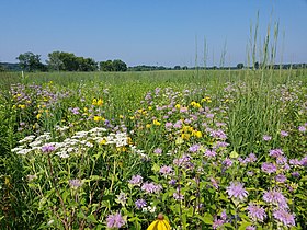 Warrenville Grove Forest Preserve on the West Branch of the DuPage River, Restored tallgrass prairie | |
 Seal | |
| Motto(s): The Magnificent Miles West of Chicago | |
 Location within the U.S. state of Illinois | |
 Illinois's location within the U.S. | |
| Coordinates: 41°50′N 88°05′W / 41.83°N 88.08°W | |
| Country | |
| State | |
| Founded | February 9, 1839 |
| Named for | DuPage River |
| Seat | Wheaton |
| Largest city | Aurora (population) Naperville (area) |
| Area | |
| • Total | 336 sq mi (870 km2) |
| • Land | 327 sq mi (850 km2) |
| • Water | 8.9 sq mi (23 km2) 2.6% |
| Population (2020) | |
| • Total | 932,877 |
| • Density | 2,800/sq mi (1,100/km2) |
| Time zone | UTC−6 (Central) |
| • Summer (DST) | UTC−5 (CDT) |
| Area code | 630 and 331 |
| Congressional districts | 3rd, 5th, 6th, 8th, 11th, 14th |
| Website | www |
| [1] | |


DuPage County (/ˌduːˈpeɪdʒ/) is a county in the U.S. state of Illinois, and one of the collar counties of the Chicago metropolitan area. As of the 2020 census, the population was 932,877, making it Illinois' second-most populous county. Its county seat is Wheaton.[2]
Known for its vast Tallgrass prairies, DuPage County has become mostly developed and suburbanized, although some pockets of farmland remain in the county's western and northern parts. Located in the Rust Belt, the area is one of few in the region whose economy quickly became dependant on the headquarters of several large corporations due to its close proximity to Chicago. As steel mills closed in the 1970s and 1980s, several acres that were formally industrialized areas were converted into business parks to meet the growing tax base. The county has a mixed socioeconomic profile and residents of Hinsdale, Naperville and Oak Brook include some of the wealthiest people in the Midwest. On the whole, the county enjoys above average median household income levels and low overall poverty levels when compared to the national average.[3] In 2018, Niche ranked two DuPage municipalities (Clarendon Hills #3 and Naperville #16) amongst the top 20 best places to live in America.[4]
History[]
DuPage County was formed on February 9, 1839 out of Cook County.[5] The county took its name from the DuPage River, which was, in turn, named after a French fur trapper, DuPage.[6] The first written history to address the name, the 1882 History of DuPage County, Illinois, by Rufus Blanchard, relates:[7]
The DuPage River had, from time immemorial, been a stream well known. It took its name from a French trader who settled on this stream below the fork previous to 1800. Hon. H. W. Blodgett, of Waukegan, informs the writer that J. B. Beaubien had often spoken to him of the old Frenchman, Du Page, whose station was on the bank of the river, down toward its mouth, and stated that the river took its name from him. The county name must have the same origin. Col Gurden S. Hubbard, who came into the country in 1818, informs the writer that the name DuPage, as applied to the river then, was universally known, but the trader for whom it was named lived there before his time. Mr. Beaubien says it is pronounced Du Pazhe (a having the sound of ah, and that the P should be a capital). This was in reply to Mr. Blodgett’s inquiry of him concerning the matter.
The first white settler in DuPage County was Bailey Hobson, who, with Lewis Stewart, built a house in 1831 for the Hobson family at a site about 2 miles south of present-day downtown Naperville.[8][9] Hobson later built a mill to serve surrounding farmers. Today, the Hobson house still stands on Hobson Road in Naperville, and the location of the mill is commemorated with a millstone and monument in today's Pioneer Park.[10]
Geography[]
According to the U.S. Census Bureau, the county has a total area of 336 square miles (870 km2), of which 327 square miles (850 km2) is land and 8.9 square miles (23 km2) (2.6%) is water.[11] The DuPage River and the Salt Creek flow through DuPage County. According to the Forest Preserve District of DuPage County, the highest point in the county is located at the Mallard Lake Landfill, which at its highest point is 982 feet (299 m) above mean sea level.[12]
Climate[]
| Wheaton, Illinois | ||||||||||||||||||||||||||||||||||||||||||||||||||||||||||||
|---|---|---|---|---|---|---|---|---|---|---|---|---|---|---|---|---|---|---|---|---|---|---|---|---|---|---|---|---|---|---|---|---|---|---|---|---|---|---|---|---|---|---|---|---|---|---|---|---|---|---|---|---|---|---|---|---|---|---|---|---|
| Climate chart (explanation) | ||||||||||||||||||||||||||||||||||||||||||||||||||||||||||||
| ||||||||||||||||||||||||||||||||||||||||||||||||||||||||||||
| ||||||||||||||||||||||||||||||||||||||||||||||||||||||||||||
In recent years, average temperatures in the county seat of Wheaton have ranged from a low of 14 °F (−10 °C) in January to a high of 87 °F (31 °C) in July, although a record low of −26 °F (−32 °C) was recorded in January 1985 and a record high of 105 °F (41 °C) was recorded in July 1995. Average monthly precipitation ranged from 1.56 inches (40 mm) in February to 4.60 inches (117 mm) in August.[13]
Adjacent counties[]
Counties that are adjacent to DuPage include:
- Cook County (east and north)
- Will County (south)
- Kendall County (southwest; counties meet at a corner)
- Kane County (west)
Major Highways[]
Demographics[]
| Historical population | |||
|---|---|---|---|
| Census | Pop. | %± | |
| 1840 | 3,535 | — | |
| 1850 | 9,290 | 162.8% | |
| 1860 | 14,701 | 58.2% | |
| 1870 | 16,685 | 13.5% | |
| 1880 | 19,161 | 14.8% | |
| 1890 | 22,551 | 17.7% | |
| 1900 | 28,196 | 25.0% | |
| 1910 | 33,432 | 18.6% | |
| 1920 | 42,120 | 26.0% | |
| 1930 | 91,998 | 118.4% | |
| 1940 | 103,480 | 12.5% | |
| 1950 | 154,599 | 49.4% | |
| 1960 | 313,459 | 102.8% | |
| 1970 | 491,882 | 56.9% | |
| 1980 | 658,835 | 33.9% | |
| 1990 | 781,666 | 18.6% | |
| 2000 | 904,161 | 15.7% | |
| 2010 | 916,924 | 1.4% | |
| 2020 | 932,877 | 1.7% | |
| U.S. Decennial Census[14] 1790-1960[15] 1900-1990[16] 1990-2000[17] 2010-2019[18] | |||
DuPage County's population's distribution by race and ethnicity in the 2010 census was as follows:[19]
| Race / Ethnicity | Percentage of county population |
|---|---|
| White | 77.9 % |
| Asian | 10.1 % |
| Black or African American | 4.6 % |
| American Indian and Alaska Native | 0.3 % |
| Native Hawaiian and Other Pacific Islander | 0.0 % |
| Two or more races | 2.2 % |
| Hispanic or Latino | 13.3 % |
| White, not Hispanic or Latino | 70.5 % |
DuPage County has become more diverse. The population of foreign-born residents increased from about 71,300 in 1990 to 171,000 by 2009 estimates.[20]
There were 325,601 households, out of which 37.00% had children under the age of 18 living with them, 60.90% were married couples living together, 7.90% had a female householder with no husband present and 28.00% were non-families. 22.90% of all households were made up of individuals, and 6.80% had someone living alone who was 65 years of age or older. The average household size was 2.73 and the average family size was 3.27.
In the county, the population was spread out, with 26.70% under the age of 18, 8.20% from 18 to 24, 32.40% from 25 to 44, 22.80% from 45 to 64 and 9.80% who were 65 years of age or older. The median age was 35 years. For every 100 females, there were 97.20 males. For every 100 females, age 18 and over, there were 94.20 males.
The median income for a household in the county was $98,441 and the median income for a family was $113,086.[21] Males had a median income of $60,909 versus $41,346 for females. The mean or average income for a family in DuPage County is $121,009, according to the 2005 census. The per capita income for the county was $38,458. About 2.40% of families and 3.60% of the population were below the poverty line, including 3.90% of those under age 18 and 4.30% of those age 65 or over.[21]
Religion[]

DuPage County has several hundred Christian churches, and especially around Wheaton is a Bible Belt, with Wheaton College and various other evangelical Christian colleges, publishing houses, and Christianity Today in the area. Well-known churches include Community Christian Church of Naperville, College Church of Wheaton, Wheaton Bible Church, and First Baptist Church of Wheaton. There is also a large Catholic contingency, part of the Diocese of Joliet, and a Ukrainian Orthodox Church in Glendale Heights.
The Theosophical Society in America in Wheaton, the North American headquarters of the Theosophical Society Adyar, provides lectures and classes on theosophy, meditation, yoga, Eastern and New Age spirituality. Islamic mosques are located in Villa Park, Naperville (two mosques), Glendale Heights, Willowbrook, Westmont, Lombard, Bolingbrook, Addison, Woodale, West Chicago, and unincorporated Glen Ellyn.[22] There are Hindu temples in Bartlett, Bensenville, Bloomingdale, Carol Stream, Itasca and Medinah, and an Arya Samaj center in West Chicago. There is a Nichiren Shōshū Zen Buddhist temple in West Chicago[23] and a Theravada Buddhist Temple, called the Buddha-Dharma Meditation Center, in Willowbrook.[24] There is also a Reform synagogue, Congregation Etz Chaim, in Lombard and an unaffiliated one in Naperville.
Economy[]
DuPage County is the primary location of the Illinois Technology and Research Corridor. It is home to many large corporations, including:
- Ace Hardware (Oak Brook)
- Arthur J. Gallagher & Co. (Itasca) (Fortune 1000)
- BP (formerly British Petroleum) (Warrenville)
- DeVry Inc. (Oakbrook Terrace) (NYSE)
- Dover Corporation (Downers Grove) (Fortune 500)
- Eby-Brown (Naperville)
- Hub Group (Oak Brook) (Fortune 1000)
- Molex (Lisle) (Fortune 1000)
- Nalco Holding Company (Naperville) (Fortune 1000)
- Namco Cybertainment (Bensenville)
- Navistar International (Lisle) (Fortune Global 500)
- Nicor (Naperville) (Fortune 1000)
- OfficeMax (Naperville) (Fortune 500)
- Sara Lee Corporation (Downers Grove) (Fortune 500)
- Tellabs (Naperville) (Fortune 1000)
- Ty Warner (Beanie Babies) (Westmont)
Shopping malls in DuPage County include Oakbrook Center, which is the largest open-air mall in the nation, Westfield Fox Valley, Yorktown Center, Town Square Wheaton, and Stratford Square Mall. In addition, many of DuPage County's towns have prosperous and quaint downtown areas, especially in Naperville, Glen Ellyn, Elmhurst, Wheaton, Downers Grove and Hinsdale, which are mixed with boutiques, upscale chain stores and restaurants.
National Laboratories[]
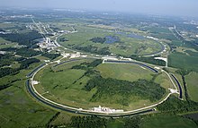
Fermilab, which has the world's second-highest-energy particle accelerator,[25] is in Batavia, where it straddles the border between Kane and DuPage counties.[26] Argonne National Laboratory, one of the United States government's oldest and largest science and engineering research laboratories,[27] is in unincorporated, southeast DuPage County.[28] Both laboratories conduct tours of their facilities.
Arts and culture[]
Architecture[]
The 31-story Oakbrook Terrace Tower in Oakbrook Terrace, designed by Helmut Jahn, is the tallest building in Illinois outside of Chicago.[29] The Elmhurst Art Museum is housed in a Mies Van Der Rohe building. There is a Frank Lloyd Wright house in Elmhurst. Bochasanwasi Shri Akshar Purushottam Swaminarayan Sanstha, a conservative Hindu sect, has built BAPS Shri Swaminarayan Mandir Chicago, a large, intricately carved, marble temple in Bartlett. There are some Sears Catalog Homes in Downers Grove and Villa Park. The Byzantine-style clubhouse of the Medinah Country Club is also an architectural highlight of the county. Lombard is home to over thirty Lustron prefabricated steel homes.[30]
Museums and historical sites[]
Historical museums in DuPage County include:
- Cantigny Park and First Division Museum, on the former estate of Chicago Tribune magnate Robert R. McCormick (Wheaton)
- Downers Grove Museum (Downers Grove)
- DuPage County Historical Museum, formerly the Adams Memorial Library (Wheaton)
- Graue Mill (Oak Brook)
- Gregg House Museum (Westmont)
- Itasca Historical Depot Museum (Itasca)
- Kline Creek Farm (West Chicago)
- Mayslake Peabody Estate (Oak Brook)
- The Museums at Lisle Station Park (Lisle)
- Naper Settlement (Naperville)
- Villa Park Historical Society Museum (Villa Park)
- West Chicago's City Museum (West Chicago)
Specialty museums in DuPage County include:
- (Naperville)
- Elmhurst Art Museum, which includes Mies Van Der Rohe's McCormick House[31] (Elmhurst)
- Wheaton College (Wheaton)

Historical sites include:
- Downtown Hinsdale Historic District
- DuPage County Courthouse (Wheaton)[32]
- Glen Ellyn Main Street Historic District
- Joe Naper's General Store (Naperville)[33]
- Naperville Historic District
- Old Nichols Library (Naperville)[34]
- Pioneer Park, monument to white settlers of DuPage County and site of Bailey Hobson's mill (Naperville)[35]
- Stacy's Tavern (Glen Ellyn)
- Wayne Village Historic District
Music and theater[]
DuPage also plays host to a rich, local music scene. Some of the better-known bands to come out of the area include The Hush Sound, Lucky Boys Confusion, and Plain White T's.
Oakbrook Terrace's Drury Lane Theatre is an important live theatre in DuPage County. The Tivoli Theatre, one of the first theaters in the United States to be equipped with sound, is still in use in Downers Grove.[36] In addition to showing movies, the Tivoli is home to several local performing arts groups.[37]
Parks and recreation[]

The Forest Preserve District of DuPage County owns and manages 25,000 acres (10,000 ha) of prairies, woodlands and wetlands. More than 4 million visitors each year enjoy 60 forest preserves, 145 miles of trails, and five education centers.[38]
Local urban parks include Lombard's Lilacia Park, Naperville's Centennial Beach, Woodridge's Cypress Cove Family Aquatic Park and Wheaton's Cosley Zoo. Privately funded attractions include Lisle's Morton Arboretum.
In the 1980s, DuPage County also had another major attraction, Ebenezer Floppen Slopper's Wonderful Water slides in Oakbrook Terrace, which today, stands abandoned and neglected.
The Illinois Prairie Path, a 61-mile (98 km) rail-to-trail multi-use path, runs through Cook, DuPage and Kane Counties. It intersects with the Great Western Trail at several points, as well as the Fox River Trail at a few points.
DuPage golf courses include: Wheaton's Chicago Golf Club, Arrowhead Golf Club and Cantigny Golf courses; the Medinah Country Club; the Village Links and Glen Oak Country Club of Glen Ellyn; Addison's Oak Meadows; Oak Brook's Oak Brook Golf Club, Butler National Golf Club, and Butterfield Country Club; Wood Dale's Maple Meadows; Westmont's Green Meadows; Lisle's River Bend (9 holes); West Chicago's St. Andrews Golf & Country Club and Winfield's Klein Creek Golf Club, among others.
Government and politics[]
Government[]
This section needs to be updated. (December 2020) |
The powers of the County Board include managing county funds and business, levying taxes, and appropriating funds. The County Board exercises powers not assigned to other elected officials or other boards.[39]
The county is divided into six districts. Each district elects three members to the County Board in staggered two-year and four-year terms. The Chairman of the County Board is the chief executive officer of DuPage County, and is elected countywide every four years.
The County Board is controlled by the Democratic Party by an 11 to 7 margin.[40]
| District | Board Member | Party |
|---|---|---|
| Chairman | Daniel Cronin | Republican |
| 1 | Ashley Selmon | Democratic |
| 1 | Donald Puchalski | Republican |
| 1 | Sam Tornatore | Republican |
| 2 | Elizabeth Chaplin | Democratic |
| 2 | Pete DiCianni | Republican |
| 2 | Paula Deacon Garcia | Democratic |
| 3 | Julie Renehan | Democratic |
| 3 | Greg Hart | Republican |
| 3 | Brian Krajewski | Republican |
| 4 | Grant Eckhoff | Republican |
| 4 | Mary FitzGerald Ozog | Democratic |
| 4 | Lynn LaPlante | Democratic |
| 5 | Amy Chavez | Democratic |
| 5 | Sadia Covert | Democratic |
| 5 | Dawn DeSart | Democratic |
| 6 | Greg Schwarze | Democratic |
| 6 | Sheila Rutledge | Democratic |
| 6 | James Zay | Republican |
Politics[]
DuPage County was historically a stronghold of the Republican Party, and a classic bastion of suburban conservatism. In recent years, DuPage County has joined other suburban counties outside large U.S. cities trending Democratic in presidential election years since the 1990s. The county continues to lean Republican in state and local politics, however in the 2018 Illinois gubernatorial election, J. B. Pritzker became the first Democratic candidate for the governorship to win the county in more than 100 years.
National politics[]
The county supported Barack Obama, a Chicago resident, in 2008 and 2012 (albeit narrowly in 2012). Obama was the first Democratic presidential nominee to win the county since Franklin Pierce in 1852. The only time prior to 2008 that a Republican had failed to win the county was in 1912, when the GOP was mortally divided and former President and Progressive Party nominee Theodore Roosevelt won over half the county's vote.
DuPage County has historically been a fiscally and socially conservative Republican stronghold, though in recent years has become more politically liberal especially on issues of race and immigration.[42][43] DuPage County has been shifting more Democratic, with Joe Biden winning 58% of the vote in 2020. DuPage County has not voted for a Republican candidate for president since 2004. Donald Trump was the first Republican nominee for President since 1912 to get less than 40% of the DuPage County vote, both in the 2016 and 2020 general elections. Many DuPage County communities which normally vote Republican, including but not limited to Naperville, Lisle, Wheaton, Glen Ellyn, Carol Stream, Downers Grove, and Elmhurst did not support Donald Trump in 2016.[44] In December 2019, shortly after the U.S. House of Representatives voted to impeach Donald Trump, Carol Stream-based Christianity Today published a controversial editorial calling for the removal of Trump from office, citing the need to hold him to the same standards to which they held Bill Clinton in the 1990s (who was the last Democratic nominee for President to get less than 40% of the DuPage County vote).[45]
In the U.S. House of Representatives, DuPage County is in the 5th, 6th, 8th, 11th and 14th districts. In the 2018 general election, despite the county's historical Republican dominance, Democrats won every congressional district within the county.[46]
Local politics[]
Republicans historically controlled local politics in DuPage County from the nineteenth century until modern times. Democrats have only held countywide office twice. In 1934 William Robinson was elected Circuit Clerk and Arthur Hellyer was elected Treasurer. That year also saw the only Democratic majority county board in DuPage history.[47][48] Robinson and Hellyer each served one term; Robinson lost his bid for a full term in 1936 and Hellyer left the Treasurer's office to make a failed bid for probate judge in 1938.[49] In 2018, as part of a larger suburban realignment, Democratic candidate Jean Kaczmarek won the election for County Clerk and Daniel Hebreard won the President of the Forest Preserve District of DuPage County.[46][50][51]
During that same period Democrats were sporadically elected at the county board township levels. In 1972, Don Carroll was elected to the County Board. In the Democratic wave of 1974, Jane Spirgel, Mary Eleanor Wall, and Elaine Libovicz were elected. All four were from the northeastern portion of DuPage, which at that time was the most Democratic.[52] Republicans regained all seats on the board when Jane Spirgel ran for Illinois Secretary of State with Adlai Stevenson III under the Solidarity Party banner.[53] In 2000, Linda J. Bourke Hilbert was elected. Like her 1970s counterparts, she was from the northeastern portion of the county.[54] During the 2008 Democratic wave, three Democrats were elected to the board.[55] After the initial Obama wave, Republicans reasserted themselves on the board and by 2017 Democrats held only one of the eighteen board seats. In the 2018 general election, Democrats won seven seats as well as the offices of County Clerk and Forest Preserve District President.[46]
In 1973, a slate of Democrats took eight of nine offices in Addison Township. This feat would not be replicated until 2017 when Democratic candidates won a majority of offices in Naperville and Lisle townships.[56] Between these two victories, Democrats only held two township offices. Mark Starkovich served as York Township Supervisor from 1989-1993 and Martin McManamon has served as Wayne Township Highway Commissioner since 2013.[57][58]
In 2020, Democrats won control of the DuPage County Board, expanding on their 2018 lead.[59]
Education[]
Colleges and universities[]

The College of DuPage, in Glen Ellyn, is one of the largest community colleges in the United States. Wheaton College is one of the most well-known and respected evangelical Christian colleges in the country. Benedictine University, Elmhurst University and North Central College also have long and respected histories in their communities.
Other prominent colleges and universities include: Midwestern University in Downers Grove; National University of Health Sciences and Northern Baptist Theological Seminary in Lombard; the Addison, Naperville and Oak Brook campuses of DeVry University; the Aurora campus of Robert Morris University; the Lisle campus of National–Louis University; the Naperville campus of Northern Illinois University; and the Wheaton campus of Illinois Institute of Technology.
Secondary schools[]
Dupage County is home to many academically and athletically successful public high schools, such as:
- Addison Trail High School
- Bartlett High School
- Downers Grove North High School
- Downers Grove South High School
- Fenton High School
- Glenbard East High School
- Glenbard North High School
- Glenbard South High School
- Glenbard West High School
- Hinsdale Central High School
- Hinsdale South High School
- Lake Park High School
- Lisle High School
- Metea Valley High School
- Naperville North High School
- Naperville Central High School
- Waubonsie Valley High School
- West Chicago Community High School
- Westmont High School
- Wheaton North High School
- Wheaton Warrenville South High School
- Willowbrook High School
- York Community High School
Additionally, DuPage County is home to several private high schools, including:
- Benet Academy
- [60]
- Driscoll Catholic High School (closed 2009)
- Immaculate Conception High School
- Islamic Foundation School
- Montini Catholic High School
- St. Francis High School
- Timothy Christian School
- Wheaton Academy
School districts[]
The DuPage County Regional Office of Education provides regulatory and compliance oversight, quality services and support, and a variety of other services and information to the public schools within the forty-two school districts of the county that provide education to over 161,000 students in 245 schools.[61]
Infrastructure[]
Health care[]
DuPage hospitals include: Central DuPage Hospital in Winfield; Edward Hospital in Naperville; Elmhurst Memorial Hospital in Elmhurst; Adventist Hinsdale Hospital in Hinsdale; Advocate Good Samaritan Hospital in Downers Grove; Adventist GlenOaks Hospital in Glendale Heights; and Marianjoy Rehabilitation Hospital and Clinics in Wheaton.
Transportation[]
Aside from the part of O'Hare International Airport that is located inside the county, DuPage also has many railroads and several small airports, including DuPage Airport. DuPage is served by the Pace bus system.
DuPage County is served by four Interstate Highways, three US Highways, and nine Illinois Routes.
North–south roads (from west to east) include: IL 59 (Sutton Road), IL 53 (Rohlwing Road), I-355 (Veterans Memorial Tollway) and IL 83 (Kingery Highway). East–west roads (from south to north) include: I-55 (Stevenson Expressway) I-88 (Ronald Reagan Memorial Tollway), US 34 (Ogden Avenue), IL 56 (Butterfield Road), IL 38 (Roosevelt Road), IL 64 (North Avenue), Army Trail Road, US 20 (Lake Street), IL 19 (Irving Park Road) and IL 390 (Elgin–O'Hare Expressway), which begins at the Thorndale Avenue exit on I-290 and ends on Lake Street, in Hanover Park. I-294 partially enters DuPage County on its eastern border between Westchester, in Cook County, and Oak Brook, in DuPage County. Only the southbound lanes enter the county though.
DuPage County is also well-covered by Metra, the Chicago-area commuter rail system. Three of Metra's eleven lines pass through the county: Milwaukee District / West Line, Union Pacific / West Line, and BNSF. Nineteen Metra stations are within DuPage County.
Communities[]
Cities[]
- Aurora (part)
- Batavia (part)
- Chicago (part)
- Darien
- Elmhurst (mostly)
- Naperville (mostly)
- Oakbrook Terrace
- St. Charles (part)
- Warrenville
- West Chicago
- Wheaton
- Wood Dale
Villages[]
- Addison
- Bartlett (mostly)
- Bensenville (mostly)
- Bloomingdale
- Bolingbrook (part)
- Burr Ridge (part)
- Carol Stream
- Clarendon Hills
- Downers Grove
- Elk Grove Village (part)
- Glendale Heights
- Glen Ellyn
- Hanover Park (Part)
- Hinsdale (mostly)
- Itasca
- Lemont (part)
- Lisle
- Lombard
- Oak Brook (mostly)
- Roselle (mostly)
- Schaumburg (part)
- Villa Park
- Wayne (part)
- Westmont
- Willowbrook
- Willow Springs (part)
- Winfield
- Woodridge (mostly)
Unincorporated communities[]
Townships[]
DuPage County has nine townships, their populations at the 2010 census are:
- Addison Township - 88,612
- Bloomingdale Township - 111,899
- Downers Grove Township - 146,795
- Lisle Township - 116,268
- Milton Township - 117,067
- Naperville Township - 100,019
- Wayne Township - 66,582
- Winfield Township - 46,233
- York Township - 123,449
Also a part of the independent City of Chicago, the southwest portion of O'Hare Airport lies within the northeast corner boundary of the county.
Ghost towns/Neighborhoods[]
See also[]
- List of counties in Illinois
- List of Illinois townships
References[]
- ^ "DuPage County". Geographic Names Information System. United States Geological Survey.
- ^ "Find a County". National Association of Counties. Archived from the original on May 31, 2011. Retrieved June 7, 2011.
- ^ "DuPage County, IL". Data USA. Retrieved October 22, 2018.
- ^ "2018 Best Places to Live in America". Niche. Retrieved October 22, 2018.
- ^ White, Jesse (March 2010). "1837-1839 — Twenty-one New Counties" (PDF). Origin and Evolution of Illinois Counties. Illinois Secretary of State. p. 10. Archived (PDF) from the original on August 6, 2012. Retrieved September 26, 2012.
- ^ Thompson, Richard A. "The French Connection". History of DuPage County: DuPage Roots. DuPageHistory.org. Archived from the original on 13 March 2009. Retrieved 3 January 2009.
- ^ Blanchard, Rufus (1882). "History of DuPage County, Illinois". Illinois Digital Archives. Illinois Secretary of State and State Librarian. Retrieved January 3, 2009.
- ^ Blanchard, Rufus (1882). History of Du Page County, Illinois. Chicago: O.L. Baskin & Co. Historical Publishers. pp. 26.
- ^ Richmond, C.W. (1877). History of Du Page County, Illinois. Aurora, Illinois: Knickerbocker & Hodder. pp. 11–12.
- ^ "Bailey Hobson: Naperville Heritage Society Stories". Naper Settlement. Archived from the original on May 8, 2018. Retrieved January 7, 2018.
- ^ "Population, Housing Units, Area, and Density: 2010 - County". United States Census Bureau. Archived from the original on February 12, 2020. Retrieved July 11, 2015.
- ^ Forest Preserve District of DuPage County (2008). "Frequently Asked Questions about Environmental Services". Archived from the original on September 27, 2007. Retrieved January 9, 2008.
- ^ Jump up to: a b "Monthly Averages for Wheaton, Illinois". The Weather Channel. Archived from the original on 13 May 2011. Retrieved 27 January 2011.
- ^ "U.S. Decennial Census". United States Census Bureau. Archived from the original on April 26, 2015. Retrieved July 4, 2014.
- ^ "Historical Census Browser". University of Virginia Library. Archived from the original on August 11, 2012. Retrieved July 4, 2014.
- ^ "Population of Counties by Decennial Census: 1900 to 1990". United States Census Bureau. Archived from the original on April 24, 2014. Retrieved July 4, 2014.
- ^ "Census 2000 PHC-T-4. Ranking Tables for Counties: 1990 and 2000" (PDF). United States Census Bureau. Archived (PDF) from the original on December 18, 2014. Retrieved July 4, 2014.
- ^ "State & County QuickFacts". United States Census Bureau. Archived from the original on June 6, 2011. Retrieved July 4, 2014.
- ^ "DuPage County, Illinois". United States Census Bureau. Retrieved December 31, 2016.
- ^ Born, Molly (February 17, 2011). "Diversity in DuPage is like a shift from vanilla to caramel fudge swirl, official says". Medill Reports Chicago. Northwestern University. Medill News Service. Archived from the original on January 2, 2017. Retrieved January 1, 2017.
- ^ Jump up to: a b "American FactFinder". United States Census Bureau. Archived from the original on February 11, 2020. Retrieved April 2, 2009.
- ^ "Home". islamiccenterofnaperville.org. Archived from the original on March 9, 2018. Retrieved May 8, 2018.
- ^ "Buddhists". www.encyclopedia.chicagohistory.org. Archived from the original on October 21, 2017. Retrieved May 8, 2018.
- ^ "Archived copy". Archived from the original on December 5, 2006. Retrieved November 24, 2006.CS1 maint: archived copy as title (link)
- ^ "About Fermilab". Fermi National Accelerator Laboratory. March 18, 2004. Archived from the original on February 4, 2010. Retrieved February 19, 2010.
- ^ "County Board District 6 map". DuPage County. 2010. Archived from the original on June 12, 2010. Retrieved February 19, 2010.
- ^ "About Argonne". Argonne National Laboratory. 2010. Archived from the original on May 14, 2011. Retrieved February 19, 2010.
- ^ "County Board District 3 map". DuPage County. 2010. Archived from the original on June 12, 2010. Retrieved February 19, 2010.
- ^ GmbH, Emporis. "Oakbrook Terrace Tower, Oakbrook Terrace - 126138 - EMPORIS". www.emporis.com. Archived from the original on September 30, 2007. Retrieved May 8, 2018.
- ^ "Lombard Lustrons". Scott Vargo. Archived from the original on October 22, 2007. Retrieved October 27, 2007.
- ^ "About the McCormick House". Elmhurst Art Museum. Archived from the original on October 5, 2013. Retrieved October 3, 2013.
- ^ "National Register Information System – Du Page County Courthouse (#78003107)". National Register of Historic Places. National Park Service. July 9, 2010. Retrieved August 18, 2020.
- ^ "Layout 1". Naper Settlement. Retrieved November 8, 2018.
- ^ "Historic District | The City of Naperville". www.naperville.il.us. Retrieved August 11, 2018.
- ^ "A Brief History: The Pioneers of Pioneer Park". A Brief History. August 22, 2011. Retrieved August 11, 2018.
- ^ Max Grinnell, "Going to the Movies" Archived September 23, 2008, at the Wayback Machine The Electronic Encyclopedia of Chicago, 2005, Chicago Historical Society
- ^ Tivoli Theatre history Archived April 2, 2008, at the Wayback Machine
- ^ "Forest Preserve District Budget Approved for 2013-2014". Forest Preserve District of DuPage County. Archived from the original on October 3, 2013. Retrieved October 3, 2013.
- ^ "County Board Overview". DuPage County. Archived from the original on December 29, 2016. Retrieved December 29, 2016.
- ^ "County Board Members". DuPage County. Retrieved January 8, 2021.
- ^ Leip, David. "Dave Leip's Atlas of U.S. Presidential Elections". uselectionatlas.org. Archived from the original on March 23, 2018. Retrieved May 8, 2018.
- ^ "White mothers in Wheaton come together to design Black Lives Matter signs". Retrieved June 28, 2020.
- ^ "Roskam on immigration: 'We want those very people among us'". Retrieved June 28, 2020.
- ^ "Mapping the suburban vote for Trump, Clinton". Retrieved April 12, 2020.
- ^ "Trump Should Be Removed from Office". Retrieved April 12, 2020.
- ^ Jump up to: a b c Rakow, Bob (November 14, 2018). "Blue Wave hits DuPage County". My Suburban Life. Retrieved November 21, 2018.
- ^ "Democrats Hold Jubilee as New Officials Go In". Chicago Tribune. December 4, 1934. ProQuest 181618400.
- ^ "Democrats Win Two DuPage Offices". Daily Herald. November 9, 1934. p. 15. Archived from the original on April 19, 2017. Retrieved April 17, 2017.
- ^ "G.O.P. Banners Wave Over Five Nearby Counties: Democratic Office Holders Ousted by Voters". Chicago Tribune. November 9, 1938.
- ^ Miller, Rich (November 20, 2018). "The Democrats' vote-by-mail juggernaut". Capitol Fax. Retrieved November 21, 2018.
- ^ The Forest Preserve District of DuPage County is a countywide special district coterminous with DuPage County, Illinois
- ^ Sherlock, Barbara; Shallwani, Pervaiz (November 8, 2002). "DuPage Democrats hope board exile short-lived". Chicago Tribune. Chicago, Illinois.
- ^ Schmeltzer, John (May 6, 1986). "Spirgel one of a kind in Du Page". Chicago Tribune. Chicago, Illinois.
- ^ Trebe, Patricia (May 6, 1986). "Linda J. Bourke Hilbert, 63 ; DuPage County Board's 1st Democrat since '80s". Chicago Tribune. Chicago, Illinois.
- ^ Napolitano, Jo (November 5, 2008). "Democrats gaining a foothold". Chicago Tribune. Chicago, Illinois.
- ^ Erin, Hegarty (April 5, 2017). "Dems unseat several incumbents in Naperville, Lisle township races". Chicago Tribune. Chicago, Illinois. Archived from the original on April 16, 2017. Retrieved April 17, 2017.
- ^ Young, Linda (April 22, 1993). "Democrats lose toehold and confidence in future". Chicago Tribune. Chicago, Illinois.
- ^ Fleming, Tabitha (April 5, 2017). "Dust settles, Wayne Township highways chief emerges among DuPage victors". DuPage Policy Journal. Chicago, Illinois: Local Government Information Services.
- ^ https://www.mysuburbanlife.com/2020/11/11/dupage-county-board-democrats-ride-blue-wave-in-election/a9q08ay/
- ^ "Contact Us". Lombard, Illinois: College Preparatory School of America. Archived from the original on October 5, 2013. Retrieved October 3, 2013.
- ^ "2008-2009 Annual Report" (PDF). DuPage Regional Office of Education. Archived from the original (PDF) on October 9, 2010. Retrieved October 18, 2010.
External links[]
- Official website
- DuPage Convention & Visitors Bureau
- DuPage County Fair Grounds in Wheaton
- DuPage County Historical Society
- Forest Preserve District of DuPage County
- Forest Preserve District of DuPage County Golf Facilities
| show Places adjacent to DuPage County, Illinois |
|---|
| show Municipalities and communities of DuPage County, Illinois, United States |
|---|
| show Chicago metropolitan area |
|---|

| show |
|---|

| show Authority control |
|---|
Coordinates: 41°50′N 88°05′W / 41.833°N 88.083°W
- Illinois counties
- DuPage County, Illinois
- 1839 establishments in Illinois
- Chicago metropolitan area
- Populated places established in 1839