West Easton, Pennsylvania
West Easton | |
|---|---|
| Borough of West Easton | |
 War Monument Park in West Easton. | |
 Location of West Easton in Northampton County, Pennsylvania. | |
 West Easton Location of West Easton in Pennsylvania | |
| Coordinates: 40°40′42″N 75°14′10″W / 40.67833°N 75.23611°WCoordinates: 40°40′42″N 75°14′10″W / 40.67833°N 75.23611°W | |
| Country | United States |
| State | Pennsylvania |
| County | Northampton |
| Incorporated | June 6, 1898 |
| Government | |
| • Type | Strong Council |
| • Mayor | Dan Depaul |
| • Council Pres. | Matthew Dees |
| Area | |
| • Total | 0.34 sq mi (0.87 km2) |
| • Land | 0.30 sq mi (0.79 km2) |
| • Water | 0.03 sq mi (0.08 km2) |
| Elevation | 230 ft (70 m) |
| Population (2010) | |
| • Total | 1,257 |
| • Estimate (2019)[2] | 1,250 |
| • Density | 4,098.36/sq mi (1,580.75/km2) |
| Time zone | UTC-5 (EST) |
| • Summer (DST) | UTC-4 (EDT) |
| ZIP code | 18042 |
| Area code(s) | 610 and 484 |
| FIPS code | 42-82832 |
| Website | www |


West Easton is a borough in Northampton County, Pennsylvania, United States. West Easton is located in the Lehigh Valley region of the state, in the greater Easton area.
The population of West Easton was 1,257 at the 2010 census.
History[]
The Borough of West Easton can trace its origin to the heirs of William Penn. In 1737 the Penns sold 500 acres of land to a James Hamilton, who in turn sold the land to Garrett Moor. In 1772, Mr. Moor sold 200 acres of the land to John Philip Odenwelder, Sr. In 1834 his son, John III laid out the Village of Odenweldertown. Adjoining his acreage was land that eventually became the Village of Mutchlertown in 1872. By 1877, Mutchlertown had 35 frame homes.
The Borough of West Easton was incorporated by the Court of Quarter Sessions of Northampton County, PA, on May 30, 1898. However, the Decree of Incorporation was not filed until June 6, 1898, making the June 6 date its official date of incorporation.
Its incorporation was strenuously opposed by a large number of property owners and it was a slim majority who signed in favor of it. Only after a heated debate before Judge Schuyler on June 10, 1898, did he deny the minority's objections to incorporation, and upheld the charter granted. Odenweldertown and Mutchlertown were successfully merged and became, The Borough of West Easton.
The first Borough officers were elected to office on July 12, 1898.
By the 1920s and into the 1930s, West Easton was a hub of manufacturing activity and employment opportunities, with mills producing textiles and small businesses providing services. The population increased to its historical peak in the 1930 census. By then, West Easton had its own school, youth sports teams, a trolley connection, railroad freight and coal lines, a police department, a self-supporting volunteer fire company, and numerous community committees staffed by involved citizens.
In the decades following WWII, West Easton felt the same effects of many prosperous towns dependent upon industry that was succumbing to imported goods and production lines that required fewer human workers. Industry in West Easton steadily declined. Population saw a decrease. The Livingstone School closed in 1974. West Easton's youth sports programs ended and committees could not retain enough active members. The West Easton Police Department closed in 1965 and police protection was provided by contracting with a neighboring communities until contracting was not offered for 2013. West Easton turned to Pennsylvania State Police for protection after failing to find another community who would offer affordable police services by contract.
The Safety First Volunteer Fire Company still exists, though it is no longer self-supporting through its social club income, and relies on support from the borough.
Despite the challenges West Easton faces it is currently a financially healthy community, having no debt, no bonds floated, obtaining government grants to make infrastructure improvements, and seeing a small increase of businesses taking up residence in the last decade.
In 2016, following the installation of new council members, West Easton leadership concentrated on improving the community by seeking grant awards, volunteerism, and re-establishing its own police department. It created an on-line presence in 2016 with its first working website, WestEastonBorough.com, followed soon after with its own Facebook page to help keep residents informed, and provide transparency in local government.
In 2017, it began to concentrate on previously neglected infrastructure, including roads and public sidewalks. In November, 2018, West Easton erected its first Public Works Building for the community that will be completed in multiple phases, as grants are awarded for each phase of the project. In May, 2019, West Easton made improvements to its War Monument Park with the addition of a War Memorial Fountain and landscaping work, in an ongoing project to be funded with grants.
In November, 2019, West Easton swore in a Chief of Police, following years that involved government required paperwork, finding a building and making repairs, purchasing vehicles and equipment, and other needs in re-launching a police department.
The roll-out of West Easton's part-time police department was planned for early 2020, but due to the Covid-19 pandemic it didn't see a full compliment of part-time police officers until mid-2021.
Geography[]
West Easton is located at 40°40′42″N 75°14′10″W / 40.67833°N 75.23611°W (40.678298, -75.236144).[3]
According to the United States Census Bureau, the borough has a total area of 0.3 square miles (0.78 km2), of which, 0.3 square miles (0.78 km2) of it is land and 0.04 square miles (0.10 km2) of it (8.82%) is water.
Demographics[]
As of the census[5] of 2010, there were 1,257 people, 488 households, and 175 families residing in the borough. The population density was 4,008 people per square mile (1,434.8/km2). There were 516 housing units at an average density of 1,539.3 per square mile (600.3/km2). The racial makeup of the borough was 85.0% White, 3.8% African American, 0.3% Native American, 0.7% Asian, 0.2% from other races, and 0.7% from two or more races. Hispanic or Latino of any race were 8.4% of the population.
There were 488 households, out of which 33.4% had children under the age of 18 living with them, 50.7% were married couples living together, 12.8% had a female householder with no husband present, and 30.8% were non-families. 25.4% of all households were made up of individuals, and 8.2% had someone living alone who was 65 years of age or older. The average household size was 2.55 and the average family size was 3.04.
In the borough the population was spread out, with 25.0% under the age of 18, 7.7% from 18 to 24, 32.1% from 25 to 44, 21.4% from 45 to 64, and 13.7% who were 65 years of age or older. The median age was 38 years. For every 100 females there were 95.6 males. For every 100 females age 18 and over, there were 95.9 males.
The median income for a household in the borough was $39,615, and the median income for a family was $48,393. Males had a median income of $35,288 versus $25,781 for females. The per capita income for the borough was $17,901. About 9.5% of families and 9.9% of the population were below the poverty line, including 11.2% of those under age 18 and 9.0% of those age 65 or over.
Public education[]
The Borough is served by the Wilson Area School District.
Gallery[]

Borough Hall
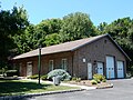
Borough Hall
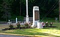
Monument Park

War Memorial Fountain

West Easton Fire Co.
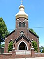
Ukrainian Catholic Church

House on Spring Street
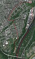
Satellite Image of West Easton


References[]
- ^ "2019 U.S. Gazetteer Files". United States Census Bureau. Retrieved July 28, 2020.
- ^ Jump up to: a b "Population and Housing Unit Estimates". United States Census Bureau. May 24, 2020. Retrieved May 27, 2020.
- ^ "US Gazetteer files: 2010, 2000, and 1990". United States Census Bureau. 2011-02-12. Retrieved 2011-04-23.
- ^ "Census of Population and Housing". U.S. Census Bureau. Archived from the original on 4 July 2013. Retrieved 11 December 2013.
- ^ Jump up to: a b "U.S. Census website". United States Census Bureau. Retrieved 2008-01-31.
- ^ "Incorporated Places and Minor Civil Divisions Datasets: Subcounty Resident Population Estimates: April 1, 2010 to July 1, 2012". Population Estimates. U.S. Census Bureau. Retrieved 11 December 2013.
- ^ 2010 Census Interactive Population https://www.census.gov/2010census/popmap/ipmtext.php?fl=42
External links[]
| Wikimedia Commons has media related to West Easton, Pennsylvania. |
| show Municipalities and communities of Northampton County, Pennsylvania, United States |
|---|

| show Authority control |
|---|
- Populated places established in 1860
- Boroughs in Northampton County, Pennsylvania
- 1898 establishments in Pennsylvania