Čechy pod Kosířem
Čechy pod Kosířem | |
|---|---|
 Panorama of Čechy pod Kosířem | |
 Flag  Coat of arms | |
 Čechy pod Kosířem Location in the Czech Republic | |
| Coordinates: 49°33′4″N 17°2′16″E / 49.55111°N 17.03778°ECoordinates: 49°33′4″N 17°2′16″E / 49.55111°N 17.03778°E | |
| Country | |
| Region | Olomouc |
| District | Prostějov |
| First mentioned | 1131 |
| Area | |
| • Total | 9.18 km2 (3.54 sq mi) |
| Elevation | 275 m (902 ft) |
| Population (2020-01-01[1]) | |
| • Total | 1,044 |
| • Density | 110/km2 (290/sq mi) |
| Time zone | UTC+1 (CET) |
| • Summer (DST) | UTC+2 (CEST) |
| Postal code | 798 58 |
| Website | www |

Čechy pod Kosířem is a municipality and village in Prostějov District in the Olomouc Region of the Czech Republic. It has about 1,000 inhabitants.
Geography[]
Čechy pod Kosířem lies at the foot of the Velký Kosíř hill (442 m), approximately 11 kilometres (7 mi) north-west of Prostějov, 17 km (11 mi) west of Olomouc, and 197 km (122 mi) east of Prague.
History[]
It was first mentioned in 1131.
Gallery[]
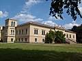
Chateau

Lookout tower in the chateau park

Church of St John the Baptist


References[]
- ^ "Population of Municipalities – 1 January 2020". Czech Statistical Office. 2020-04-30.
| Wikimedia Commons has media related to Čechy pod Kosířem. |
| Authority control: National libraries |
|---|
This Olomouc Region location article is a stub. You can help Wikipedia by . |
Categories:
- Villages in Prostějov District
- Olomouc Region geography stubs