Anzême
Anzême | |
|---|---|
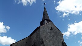
 The bell tower of the church in Anzême | |
 Anzême | |
| Coordinates: 46°16′39″N 1°51′52″E / 46.2775°N 1.8644°ECoordinates: 46°16′39″N 1°51′52″E / 46.2775°N 1.8644°E | |
| Country | France |
| Region | Nouvelle-Aquitaine |
| Department | Creuse |
| Arrondissement | Guéret |
| Canton | Saint-Vaury |
| Intercommunality | CA Grand Guéret |
| Government | |
| • Mayor (2020–2026) | Viviane Dupeux |
| Area 1 | 29.50 km2 (11.39 sq mi) |
| Population (Jan. 2018)[1] | 566 |
| • Density | 19/km2 (50/sq mi) |
| Time zone | UTC+01:00 (CET) |
| • Summer (DST) | UTC+02:00 (CEST) |
| INSEE/Postal code | 23004 /23000 |
| Elevation | 254–441 m (833–1,447 ft) (avg. 325 m or 1,066 ft) |
| 1 French Land Register data, which excludes lakes, ponds, glaciers > 1 km2 (0.386 sq mi or 247 acres) and river estuaries. | |
Anzême (French pronunciation: [ɑ̃zɛm]; Occitan: Anzesme) is a commune in the Creuse department in the Nouvelle-Aquitaine region in central France.
Geography[]
An area of farming and quarrying, comprising the village and several hamlets situated by the banks of the Creuse, some 7 miles (11 km) north of Guéret, at the junction of the D14 and the D33.
Population[]
| Year | Pop. | ±% |
|---|---|---|
| 1962 | 606 | — |
| 1968 | 707 | +16.7% |
| 1975 | 601 | −15.0% |
| 1982 | 508 | −15.5% |
| 1990 | 519 | +2.2% |
| 1999 | 535 | +3.1% |
| 2008 | 561 | +4.9% |
Sights[]
- The church of St. Pierre, dating from the thirteenth century
- A stone bridge and stone cross, both dating from the fourteenth century
- The hydroelectric dams on the river
See also[]
References[]
- ^ "Populations légales 2018". The National Institute of Statistics and Economic Studies. 28 December 2020.
| Wikimedia Commons has media related to Anzême. |
Categories:
- Communes of Creuse


