Lavaufranche
Lavaufranche | |
|---|---|
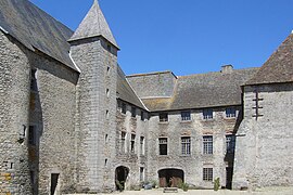 Commanderie of the Knights of St. John | |
show Location of Lavaufranche | |
 Lavaufranche | |
| Coordinates: 46°19′17″N 2°16′20″E / 46.3214°N 2.2722°ECoordinates: 46°19′17″N 2°16′20″E / 46.3214°N 2.2722°E | |
| Country | France |
| Region | Nouvelle-Aquitaine |
| Department | Creuse |
| Arrondissement | Aubusson |
| Canton | Boussac |
| Intercommunality | CC Creuse Confluence |
| Government | |
| • Mayor (2020–2026) | Patrice Orsal |
| Area 1 | 16.34 km2 (6.31 sq mi) |
| Population (Jan. 2018)[1] | 242 |
| • Density | 15/km2 (38/sq mi) |
| Time zone | UTC+01:00 (CET) |
| • Summer (DST) | UTC+02:00 (CEST) |
| INSEE/Postal code | 23104 /23600 |
| Elevation | 375–485 m (1,230–1,591 ft) (avg. 416 m or 1,365 ft) |
| 1 French Land Register data, which excludes lakes, ponds, glaciers > 1 km2 (0.386 sq mi or 247 acres) and river estuaries. | |


Lavaufranche (French pronunciation: [lavofʁɑ̃ʃ]; Occitan: La Vau Francha) is a commune in the Creuse department in the Nouvelle-Aquitaine region in central France.
Geography[]
A farming area comprising the village and a few small hamlets situated some 20 miles (32 km) northeast of Guéret at the junction of the D7, D917 and the D67 roads. The Petite Creuse river flows through the commune, which is also served by a TER railway.
Population[]
| Year | Pop. | ±% |
|---|---|---|
| 1962 | 431 | — |
| 1968 | 445 | +3.2% |
| 1975 | 367 | −17.5% |
| 1982 | 304 | −17.2% |
| 1990 | 231 | −24.0% |
| 1999 | 246 | +6.5% |
| 2008 | 243 | −1.2% |
Sights[]
- The commanderie of the Knights of Saint John, dating from the twelfth century.
- The twelfth-century chapel.
See also[]
References[]
- ^ "Populations légales 2018". INSEE. 28 December 2020.
| Wikimedia Commons has media related to Lavaufranche. |
This Creuse geographical article is a stub. You can help Wikipedia by . |
Categories:
- Communes of Creuse
- Creuse geography stubs