La Saunière
La Saunière | |
|---|---|
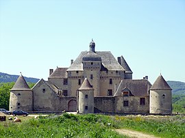 Château du Théret | |
Location of La Saunière  | |
 La Saunière | |
| Coordinates: 46°07′52″N 1°56′16″E / 46.1311°N 1.9378°ECoordinates: 46°07′52″N 1°56′16″E / 46.1311°N 1.9378°E | |
| Country | France |
| Region | Nouvelle-Aquitaine |
| Department | Creuse |
| Arrondissement | Guéret |
| Canton | Guéret-1 |
| Intercommunality | CA Grand Guéret |
| Government | |
| • Mayor (2020–2026) | Annie Zapata[1] |
| Area 1 | 7.5 km2 (2.9 sq mi) |
| Population (Jan. 2018)[2] | 620 |
| • Density | 83/km2 (210/sq mi) |
| Time zone | UTC+01:00 (CET) |
| • Summer (DST) | UTC+02:00 (CEST) |
| INSEE/Postal code | 23169 /23000 |
| Elevation | 376–560 m (1,234–1,837 ft) (avg. 450 m or 1,480 ft) |
| 1 French Land Register data, which excludes lakes, ponds, glaciers > 1 km2 (0.386 sq mi or 247 acres) and river estuaries. | |


La Saunière is a commune in the Creuse department in the Nouvelle-Aquitaine region in central France.
Geography[]
An area of farming and forestry comprising the village and a few small hamlets situated just 5 miles (8.0 km) southeast of Guéret at the junction of the D942 and the D17 roads.
Population[]
| Year | Pop. | ±% |
|---|---|---|
| 1962 | 345 | — |
| 1968 | 374 | +8.4% |
| 1975 | 332 | −11.2% |
| 1982 | 426 | +28.3% |
| 1990 | 532 | +24.9% |
| 1999 | 543 | +2.1% |
| 2008 | 629 | +15.8% |
Sights[]
- The church, dating from the twelfth century.
- The fifteenth-century château du Théret.
Personalities[]
- René Boudard (1909–2004), historian, was born here.
See also[]
References[]
- ^ "Répertoire national des élus: les maires". data.gouv.fr, Plateforme ouverte des données publiques françaises (in French). 9 August 2021.
- ^ "Populations légales 2018". The National Institute of Statistics and Economic Studies. 28 December 2020.
| Wikimedia Commons has media related to La Saunière. |
This Creuse geographical article is a stub. You can help Wikipedia by . |
Categories:
- Communes of Creuse
- Creuse geography stubs